Randonnée Marche Saint-Marc-la-Lande - Mazières-en-Gâtine 6 chemins - Photo
 Philippe Baraton
Philippe Baraton

Utilisateur

© OpenStreetMap contributors
Longueur
Longueur
6,1 km
Altitude max
Altitude max
223 m
Dénivelé positif
Dénivelé positif
50 m
Km-Effort
Km-Effort  
6,8 km
Altitude min
Altitude min
188 m
Dénivelé négatif
Dénivelé négatif
52 m
Boucle
Boucle
Oui
Date de création :
2023-12-04 13:41:57.264
Dernière modification :
2023-12-04 15:11:55.098

(0 Avis)

Marche
Marche
1h21
Difficulté : Très facile

Scannez ce code QR pour ouvrir la randonnée dans l'application SityTrail

Application GPS de randonnée GRATUITE

Logo SityTrail SityTrail

IGN / Instituts géographiques

Télécharger SityTrail sur l'App Store Télécharger SityTrail sur Google Play

Logo SityTrail SityTrail World

Le monde est à vous

Télécharger SityTrail sur l'App Store Télécharger SityTrail sur Google Play Télécharger SityTrail sur Huawei AppGallery

À propos

Randonnée Marche de 6,1 km à découvrir à Nouvelle-Aquitaine, Deux-Sèvres, Saint-Marc-la-Lande. Cette randonnée est proposée par Philippe Baraton.

Profil altimétrique

Photos

Localisation

Pays :
France
Région :
Nouvelle-Aquitaine
Département/Province :
Deux-Sèvres
Commune :
Saint-Marc-la-Lande
Localité :
Unknown
Départ:(UTM)
705001 ; 5156848 (30T) N.

Randonnées à proximité

Randonnée Marche Mazières-en-Gâtine - Mazières-en-Gâtine Golf - Photo
Marche
Philippe Baraton

Marche

Très facile
Mazières-en-Gâtine, Nouvelle-Aquitaine, Deux-Sèvres, France
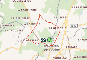
9,4 km | 10,9 km-effort
2h 10min
Oui
Randonnée Marche Saint-Pardoux-Soutiers - St pardoux les croix  - Photo
Marche
jean louis kozo

Marche

Saint-Pardoux-Soutiers, Nouvelle-Aquitaine, Deux-Sèvres, France
8,7 km | 10,1 km-effort
1h 58min
Oui
Randonnée Quad Saint-Pardoux-Soutiers - du 15 - Photo
Quad
favraux

Quad

Très facile
Saint-Pardoux-Soutiers, Nouvelle-Aquitaine, Deux-Sèvres, France
76 km | 87 km-effort
8h 41min
Non
Randonnée Marche Mazières-en-Gâtine - golf - Photo
Marche
clhote

Marche

Moyen
Mazières-en-Gâtine, Nouvelle-Aquitaine, Deux-Sèvres, France
8,1 km | 9,4 km-effort
4h 5min
Non
Randonnée Marche Verruyes - Verruyes 79 - Photo
Marche
Dom4i

Marche

Très difficile
Verruyes, Nouvelle-Aquitaine, Deux-Sèvres, France
26 km | 31 km-effort
6h 46min
Oui
Randonnée Marche Mazières-en-Gâtine - 79 MAZIERES EN GÂTINE Le Ruisseau de Monbail - Photo
Marche
maioy

Marche

Très facile
Mazières-en-Gâtine, Nouvelle-Aquitaine, Deux-Sèvres, France
7,3 km | 8,7 km-effort
1h 53min
Oui
Randonnée V.T.T. Saint-Pardoux-Soutiers - soutiers2014 - Photo
V.T.T.
STEPHAS

V.T.T.

Facile
Saint-Pardoux-Soutiers, Nouvelle-Aquitaine, Deux-Sèvres, France
54 km | 64 km-effort
5h 54min
Non


Fermer
Mes abonnements