


10,8 km | 13,8 km-effort

Utilisateur GUIDE


Application GPS de randonnée GRATUITE
 SityTrail
IGN / Instituts géographiques
SityTrail World
Le monde est à vous
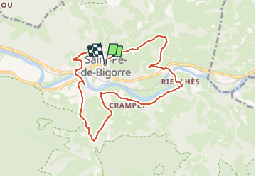
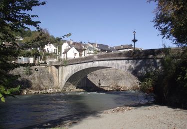
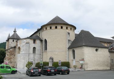
Randonnée A pied de 9,7 km à découvrir à Occitanie, Hautes-Pyrénées, Saint-Pé-de-Bigorre. Cette randonnée est proposée par marmotte65.
au départ de l'office du tourisme de Saint pe, Belle balade avec un peu de goudron, sans difficulté particulière.
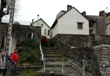
Juste un peu de vigilance sur une passerelle glissante malgré la pose de grillage, et un raidillon très glissant apres cette dite passerelle apres 3 km du départ .
le PN se fera sur un muret (assis) pas le muret , nous, au km 5.5
 "
data-pinterest-text="Pin it"
data-tweet-text="share on twitter"
data-facebook-share-url="https://www.sitytrail.com/fr/trails/3875741-saintxpexdexbigorre--saint-pe-de-bigorre-le-grand-tour-de-saint-pe-x3875741x-g4/?photo=1#lg=1&slide=1"
data-twitter-share-url="https://www.sitytrail.com/fr/trails/3875741-saintxpexdexbigorre--saint-pe-de-bigorre-le-grand-tour-de-saint-pe-x3875741x-g4/?photo=1#lg=1&slide=1"
data-googleplus-share-url="https://www.sitytrail.com/fr/trails/3875741-saintxpexdexbigorre--saint-pe-de-bigorre-le-grand-tour-de-saint-pe-x3875741x-g4/?photo=1#lg=1&slide=1"
data-pinterest-share-url="https://www.sitytrail.com/fr/trails/3875741-saintxpexdexbigorre--saint-pe-de-bigorre-le-grand-tour-de-saint-pe-x3875741x-g4/?photo=1#lg=1&slide=1">
"
data-pinterest-text="Pin it"
data-tweet-text="share on twitter"
data-facebook-share-url="https://www.sitytrail.com/fr/trails/3875741-saintxpexdexbigorre--saint-pe-de-bigorre-le-grand-tour-de-saint-pe-x3875741x-g4/?photo=1#lg=1&slide=1"
data-twitter-share-url="https://www.sitytrail.com/fr/trails/3875741-saintxpexdexbigorre--saint-pe-de-bigorre-le-grand-tour-de-saint-pe-x3875741x-g4/?photo=1#lg=1&slide=1"
data-googleplus-share-url="https://www.sitytrail.com/fr/trails/3875741-saintxpexdexbigorre--saint-pe-de-bigorre-le-grand-tour-de-saint-pe-x3875741x-g4/?photo=1#lg=1&slide=1"
data-pinterest-share-url="https://www.sitytrail.com/fr/trails/3875741-saintxpexdexbigorre--saint-pe-de-bigorre-le-grand-tour-de-saint-pe-x3875741x-g4/?photo=1#lg=1&slide=1">
 "
data-pinterest-text="Pin it"
data-tweet-text="share on twitter"
data-facebook-share-url="https://www.sitytrail.com/fr/trails/3875741-saintxpexdexbigorre--saint-pe-de-bigorre-le-grand-tour-de-saint-pe-x3875741x-g4/?photo=2#lg=1&slide=2"
data-twitter-share-url="https://www.sitytrail.com/fr/trails/3875741-saintxpexdexbigorre--saint-pe-de-bigorre-le-grand-tour-de-saint-pe-x3875741x-g4/?photo=2#lg=1&slide=2"
data-googleplus-share-url="https://www.sitytrail.com/fr/trails/3875741-saintxpexdexbigorre--saint-pe-de-bigorre-le-grand-tour-de-saint-pe-x3875741x-g4/?photo=2#lg=1&slide=2"
data-pinterest-share-url="https://www.sitytrail.com/fr/trails/3875741-saintxpexdexbigorre--saint-pe-de-bigorre-le-grand-tour-de-saint-pe-x3875741x-g4/?photo=2#lg=1&slide=2">
"
data-pinterest-text="Pin it"
data-tweet-text="share on twitter"
data-facebook-share-url="https://www.sitytrail.com/fr/trails/3875741-saintxpexdexbigorre--saint-pe-de-bigorre-le-grand-tour-de-saint-pe-x3875741x-g4/?photo=2#lg=1&slide=2"
data-twitter-share-url="https://www.sitytrail.com/fr/trails/3875741-saintxpexdexbigorre--saint-pe-de-bigorre-le-grand-tour-de-saint-pe-x3875741x-g4/?photo=2#lg=1&slide=2"
data-googleplus-share-url="https://www.sitytrail.com/fr/trails/3875741-saintxpexdexbigorre--saint-pe-de-bigorre-le-grand-tour-de-saint-pe-x3875741x-g4/?photo=2#lg=1&slide=2"
data-pinterest-share-url="https://www.sitytrail.com/fr/trails/3875741-saintxpexdexbigorre--saint-pe-de-bigorre-le-grand-tour-de-saint-pe-x3875741x-g4/?photo=2#lg=1&slide=2">
 "
data-pinterest-text="Pin it"
data-tweet-text="share on twitter"
data-facebook-share-url="https://www.sitytrail.com/fr/trails/3875741-saintxpexdexbigorre--saint-pe-de-bigorre-le-grand-tour-de-saint-pe-x3875741x-g4/?photo=3#lg=1&slide=3"
data-twitter-share-url="https://www.sitytrail.com/fr/trails/3875741-saintxpexdexbigorre--saint-pe-de-bigorre-le-grand-tour-de-saint-pe-x3875741x-g4/?photo=3#lg=1&slide=3"
data-googleplus-share-url="https://www.sitytrail.com/fr/trails/3875741-saintxpexdexbigorre--saint-pe-de-bigorre-le-grand-tour-de-saint-pe-x3875741x-g4/?photo=3#lg=1&slide=3"
data-pinterest-share-url="https://www.sitytrail.com/fr/trails/3875741-saintxpexdexbigorre--saint-pe-de-bigorre-le-grand-tour-de-saint-pe-x3875741x-g4/?photo=3#lg=1&slide=3">
"
data-pinterest-text="Pin it"
data-tweet-text="share on twitter"
data-facebook-share-url="https://www.sitytrail.com/fr/trails/3875741-saintxpexdexbigorre--saint-pe-de-bigorre-le-grand-tour-de-saint-pe-x3875741x-g4/?photo=3#lg=1&slide=3"
data-twitter-share-url="https://www.sitytrail.com/fr/trails/3875741-saintxpexdexbigorre--saint-pe-de-bigorre-le-grand-tour-de-saint-pe-x3875741x-g4/?photo=3#lg=1&slide=3"
data-googleplus-share-url="https://www.sitytrail.com/fr/trails/3875741-saintxpexdexbigorre--saint-pe-de-bigorre-le-grand-tour-de-saint-pe-x3875741x-g4/?photo=3#lg=1&slide=3"
data-pinterest-share-url="https://www.sitytrail.com/fr/trails/3875741-saintxpexdexbigorre--saint-pe-de-bigorre-le-grand-tour-de-saint-pe-x3875741x-g4/?photo=3#lg=1&slide=3">
 "
data-pinterest-text="Pin it"
data-tweet-text="share on twitter"
data-facebook-share-url="https://www.sitytrail.com/fr/trails/3875741-saintxpexdexbigorre--saint-pe-de-bigorre-le-grand-tour-de-saint-pe-x3875741x-g4/?photo=4#lg=1&slide=4"
data-twitter-share-url="https://www.sitytrail.com/fr/trails/3875741-saintxpexdexbigorre--saint-pe-de-bigorre-le-grand-tour-de-saint-pe-x3875741x-g4/?photo=4#lg=1&slide=4"
data-googleplus-share-url="https://www.sitytrail.com/fr/trails/3875741-saintxpexdexbigorre--saint-pe-de-bigorre-le-grand-tour-de-saint-pe-x3875741x-g4/?photo=4#lg=1&slide=4"
data-pinterest-share-url="https://www.sitytrail.com/fr/trails/3875741-saintxpexdexbigorre--saint-pe-de-bigorre-le-grand-tour-de-saint-pe-x3875741x-g4/?photo=4#lg=1&slide=4">
"
data-pinterest-text="Pin it"
data-tweet-text="share on twitter"
data-facebook-share-url="https://www.sitytrail.com/fr/trails/3875741-saintxpexdexbigorre--saint-pe-de-bigorre-le-grand-tour-de-saint-pe-x3875741x-g4/?photo=4#lg=1&slide=4"
data-twitter-share-url="https://www.sitytrail.com/fr/trails/3875741-saintxpexdexbigorre--saint-pe-de-bigorre-le-grand-tour-de-saint-pe-x3875741x-g4/?photo=4#lg=1&slide=4"
data-googleplus-share-url="https://www.sitytrail.com/fr/trails/3875741-saintxpexdexbigorre--saint-pe-de-bigorre-le-grand-tour-de-saint-pe-x3875741x-g4/?photo=4#lg=1&slide=4"
data-pinterest-share-url="https://www.sitytrail.com/fr/trails/3875741-saintxpexdexbigorre--saint-pe-de-bigorre-le-grand-tour-de-saint-pe-x3875741x-g4/?photo=4#lg=1&slide=4">
 "
data-pinterest-text="Pin it"
data-tweet-text="share on twitter"
data-facebook-share-url="https://www.sitytrail.com/fr/trails/3875741-saintxpexdexbigorre--saint-pe-de-bigorre-le-grand-tour-de-saint-pe-x3875741x-g4/?photo=5#lg=1&slide=5"
data-twitter-share-url="https://www.sitytrail.com/fr/trails/3875741-saintxpexdexbigorre--saint-pe-de-bigorre-le-grand-tour-de-saint-pe-x3875741x-g4/?photo=5#lg=1&slide=5"
data-googleplus-share-url="https://www.sitytrail.com/fr/trails/3875741-saintxpexdexbigorre--saint-pe-de-bigorre-le-grand-tour-de-saint-pe-x3875741x-g4/?photo=5#lg=1&slide=5"
data-pinterest-share-url="https://www.sitytrail.com/fr/trails/3875741-saintxpexdexbigorre--saint-pe-de-bigorre-le-grand-tour-de-saint-pe-x3875741x-g4/?photo=5#lg=1&slide=5">
"
data-pinterest-text="Pin it"
data-tweet-text="share on twitter"
data-facebook-share-url="https://www.sitytrail.com/fr/trails/3875741-saintxpexdexbigorre--saint-pe-de-bigorre-le-grand-tour-de-saint-pe-x3875741x-g4/?photo=5#lg=1&slide=5"
data-twitter-share-url="https://www.sitytrail.com/fr/trails/3875741-saintxpexdexbigorre--saint-pe-de-bigorre-le-grand-tour-de-saint-pe-x3875741x-g4/?photo=5#lg=1&slide=5"
data-googleplus-share-url="https://www.sitytrail.com/fr/trails/3875741-saintxpexdexbigorre--saint-pe-de-bigorre-le-grand-tour-de-saint-pe-x3875741x-g4/?photo=5#lg=1&slide=5"
data-pinterest-share-url="https://www.sitytrail.com/fr/trails/3875741-saintxpexdexbigorre--saint-pe-de-bigorre-le-grand-tour-de-saint-pe-x3875741x-g4/?photo=5#lg=1&slide=5">
 "
data-pinterest-text="Pin it"
data-tweet-text="share on twitter"
data-facebook-share-url="https://www.sitytrail.com/fr/trails/3875741-saintxpexdexbigorre--saint-pe-de-bigorre-le-grand-tour-de-saint-pe-x3875741x-g4/?photo=6#lg=1&slide=6"
data-twitter-share-url="https://www.sitytrail.com/fr/trails/3875741-saintxpexdexbigorre--saint-pe-de-bigorre-le-grand-tour-de-saint-pe-x3875741x-g4/?photo=6#lg=1&slide=6"
data-googleplus-share-url="https://www.sitytrail.com/fr/trails/3875741-saintxpexdexbigorre--saint-pe-de-bigorre-le-grand-tour-de-saint-pe-x3875741x-g4/?photo=6#lg=1&slide=6"
data-pinterest-share-url="https://www.sitytrail.com/fr/trails/3875741-saintxpexdexbigorre--saint-pe-de-bigorre-le-grand-tour-de-saint-pe-x3875741x-g4/?photo=6#lg=1&slide=6">
"
data-pinterest-text="Pin it"
data-tweet-text="share on twitter"
data-facebook-share-url="https://www.sitytrail.com/fr/trails/3875741-saintxpexdexbigorre--saint-pe-de-bigorre-le-grand-tour-de-saint-pe-x3875741x-g4/?photo=6#lg=1&slide=6"
data-twitter-share-url="https://www.sitytrail.com/fr/trails/3875741-saintxpexdexbigorre--saint-pe-de-bigorre-le-grand-tour-de-saint-pe-x3875741x-g4/?photo=6#lg=1&slide=6"
data-googleplus-share-url="https://www.sitytrail.com/fr/trails/3875741-saintxpexdexbigorre--saint-pe-de-bigorre-le-grand-tour-de-saint-pe-x3875741x-g4/?photo=6#lg=1&slide=6"
data-pinterest-share-url="https://www.sitytrail.com/fr/trails/3875741-saintxpexdexbigorre--saint-pe-de-bigorre-le-grand-tour-de-saint-pe-x3875741x-g4/?photo=6#lg=1&slide=6">
 "
data-pinterest-text="Pin it"
data-tweet-text="share on twitter"
data-facebook-share-url="https://www.sitytrail.com/fr/trails/3875741-saintxpexdexbigorre--saint-pe-de-bigorre-le-grand-tour-de-saint-pe-x3875741x-g4/?photo=7#lg=1&slide=7"
data-twitter-share-url="https://www.sitytrail.com/fr/trails/3875741-saintxpexdexbigorre--saint-pe-de-bigorre-le-grand-tour-de-saint-pe-x3875741x-g4/?photo=7#lg=1&slide=7"
data-googleplus-share-url="https://www.sitytrail.com/fr/trails/3875741-saintxpexdexbigorre--saint-pe-de-bigorre-le-grand-tour-de-saint-pe-x3875741x-g4/?photo=7#lg=1&slide=7"
data-pinterest-share-url="https://www.sitytrail.com/fr/trails/3875741-saintxpexdexbigorre--saint-pe-de-bigorre-le-grand-tour-de-saint-pe-x3875741x-g4/?photo=7#lg=1&slide=7">
"
data-pinterest-text="Pin it"
data-tweet-text="share on twitter"
data-facebook-share-url="https://www.sitytrail.com/fr/trails/3875741-saintxpexdexbigorre--saint-pe-de-bigorre-le-grand-tour-de-saint-pe-x3875741x-g4/?photo=7#lg=1&slide=7"
data-twitter-share-url="https://www.sitytrail.com/fr/trails/3875741-saintxpexdexbigorre--saint-pe-de-bigorre-le-grand-tour-de-saint-pe-x3875741x-g4/?photo=7#lg=1&slide=7"
data-googleplus-share-url="https://www.sitytrail.com/fr/trails/3875741-saintxpexdexbigorre--saint-pe-de-bigorre-le-grand-tour-de-saint-pe-x3875741x-g4/?photo=7#lg=1&slide=7"
data-pinterest-share-url="https://www.sitytrail.com/fr/trails/3875741-saintxpexdexbigorre--saint-pe-de-bigorre-le-grand-tour-de-saint-pe-x3875741x-g4/?photo=7#lg=1&slide=7">
 "
data-pinterest-text="Pin it"
data-tweet-text="share on twitter"
data-facebook-share-url="https://www.sitytrail.com/fr/trails/3875741-saintxpexdexbigorre--saint-pe-de-bigorre-le-grand-tour-de-saint-pe-x3875741x-g4/?photo=8#lg=1&slide=8"
data-twitter-share-url="https://www.sitytrail.com/fr/trails/3875741-saintxpexdexbigorre--saint-pe-de-bigorre-le-grand-tour-de-saint-pe-x3875741x-g4/?photo=8#lg=1&slide=8"
data-googleplus-share-url="https://www.sitytrail.com/fr/trails/3875741-saintxpexdexbigorre--saint-pe-de-bigorre-le-grand-tour-de-saint-pe-x3875741x-g4/?photo=8#lg=1&slide=8"
data-pinterest-share-url="https://www.sitytrail.com/fr/trails/3875741-saintxpexdexbigorre--saint-pe-de-bigorre-le-grand-tour-de-saint-pe-x3875741x-g4/?photo=8#lg=1&slide=8">
"
data-pinterest-text="Pin it"
data-tweet-text="share on twitter"
data-facebook-share-url="https://www.sitytrail.com/fr/trails/3875741-saintxpexdexbigorre--saint-pe-de-bigorre-le-grand-tour-de-saint-pe-x3875741x-g4/?photo=8#lg=1&slide=8"
data-twitter-share-url="https://www.sitytrail.com/fr/trails/3875741-saintxpexdexbigorre--saint-pe-de-bigorre-le-grand-tour-de-saint-pe-x3875741x-g4/?photo=8#lg=1&slide=8"
data-googleplus-share-url="https://www.sitytrail.com/fr/trails/3875741-saintxpexdexbigorre--saint-pe-de-bigorre-le-grand-tour-de-saint-pe-x3875741x-g4/?photo=8#lg=1&slide=8"
data-pinterest-share-url="https://www.sitytrail.com/fr/trails/3875741-saintxpexdexbigorre--saint-pe-de-bigorre-le-grand-tour-de-saint-pe-x3875741x-g4/?photo=8#lg=1&slide=8">
 "
data-pinterest-text="Pin it"
data-tweet-text="share on twitter"
data-facebook-share-url="https://www.sitytrail.com/fr/trails/3875741-saintxpexdexbigorre--saint-pe-de-bigorre-le-grand-tour-de-saint-pe-x3875741x-g4/?photo=9#lg=1&slide=9"
data-twitter-share-url="https://www.sitytrail.com/fr/trails/3875741-saintxpexdexbigorre--saint-pe-de-bigorre-le-grand-tour-de-saint-pe-x3875741x-g4/?photo=9#lg=1&slide=9"
data-googleplus-share-url="https://www.sitytrail.com/fr/trails/3875741-saintxpexdexbigorre--saint-pe-de-bigorre-le-grand-tour-de-saint-pe-x3875741x-g4/?photo=9#lg=1&slide=9"
data-pinterest-share-url="https://www.sitytrail.com/fr/trails/3875741-saintxpexdexbigorre--saint-pe-de-bigorre-le-grand-tour-de-saint-pe-x3875741x-g4/?photo=9#lg=1&slide=9">
"
data-pinterest-text="Pin it"
data-tweet-text="share on twitter"
data-facebook-share-url="https://www.sitytrail.com/fr/trails/3875741-saintxpexdexbigorre--saint-pe-de-bigorre-le-grand-tour-de-saint-pe-x3875741x-g4/?photo=9#lg=1&slide=9"
data-twitter-share-url="https://www.sitytrail.com/fr/trails/3875741-saintxpexdexbigorre--saint-pe-de-bigorre-le-grand-tour-de-saint-pe-x3875741x-g4/?photo=9#lg=1&slide=9"
data-googleplus-share-url="https://www.sitytrail.com/fr/trails/3875741-saintxpexdexbigorre--saint-pe-de-bigorre-le-grand-tour-de-saint-pe-x3875741x-g4/?photo=9#lg=1&slide=9"
data-pinterest-share-url="https://www.sitytrail.com/fr/trails/3875741-saintxpexdexbigorre--saint-pe-de-bigorre-le-grand-tour-de-saint-pe-x3875741x-g4/?photo=9#lg=1&slide=9">
 "
data-pinterest-text="Pin it"
data-tweet-text="share on twitter"
data-facebook-share-url="https://www.sitytrail.com/fr/trails/3875741-saintxpexdexbigorre--saint-pe-de-bigorre-le-grand-tour-de-saint-pe-x3875741x-g4/?photo=10#lg=1&slide=10"
data-twitter-share-url="https://www.sitytrail.com/fr/trails/3875741-saintxpexdexbigorre--saint-pe-de-bigorre-le-grand-tour-de-saint-pe-x3875741x-g4/?photo=10#lg=1&slide=10"
data-googleplus-share-url="https://www.sitytrail.com/fr/trails/3875741-saintxpexdexbigorre--saint-pe-de-bigorre-le-grand-tour-de-saint-pe-x3875741x-g4/?photo=10#lg=1&slide=10"
data-pinterest-share-url="https://www.sitytrail.com/fr/trails/3875741-saintxpexdexbigorre--saint-pe-de-bigorre-le-grand-tour-de-saint-pe-x3875741x-g4/?photo=10#lg=1&slide=10">
"
data-pinterest-text="Pin it"
data-tweet-text="share on twitter"
data-facebook-share-url="https://www.sitytrail.com/fr/trails/3875741-saintxpexdexbigorre--saint-pe-de-bigorre-le-grand-tour-de-saint-pe-x3875741x-g4/?photo=10#lg=1&slide=10"
data-twitter-share-url="https://www.sitytrail.com/fr/trails/3875741-saintxpexdexbigorre--saint-pe-de-bigorre-le-grand-tour-de-saint-pe-x3875741x-g4/?photo=10#lg=1&slide=10"
data-googleplus-share-url="https://www.sitytrail.com/fr/trails/3875741-saintxpexdexbigorre--saint-pe-de-bigorre-le-grand-tour-de-saint-pe-x3875741x-g4/?photo=10#lg=1&slide=10"
data-pinterest-share-url="https://www.sitytrail.com/fr/trails/3875741-saintxpexdexbigorre--saint-pe-de-bigorre-le-grand-tour-de-saint-pe-x3875741x-g4/?photo=10#lg=1&slide=10">
 "
data-pinterest-text="Pin it"
data-tweet-text="share on twitter"
data-facebook-share-url="https://www.sitytrail.com/fr/trails/3875741-saintxpexdexbigorre--saint-pe-de-bigorre-le-grand-tour-de-saint-pe-x3875741x-g4/?photo=11#lg=1&slide=11"
data-twitter-share-url="https://www.sitytrail.com/fr/trails/3875741-saintxpexdexbigorre--saint-pe-de-bigorre-le-grand-tour-de-saint-pe-x3875741x-g4/?photo=11#lg=1&slide=11"
data-googleplus-share-url="https://www.sitytrail.com/fr/trails/3875741-saintxpexdexbigorre--saint-pe-de-bigorre-le-grand-tour-de-saint-pe-x3875741x-g4/?photo=11#lg=1&slide=11"
data-pinterest-share-url="https://www.sitytrail.com/fr/trails/3875741-saintxpexdexbigorre--saint-pe-de-bigorre-le-grand-tour-de-saint-pe-x3875741x-g4/?photo=11#lg=1&slide=11">
"
data-pinterest-text="Pin it"
data-tweet-text="share on twitter"
data-facebook-share-url="https://www.sitytrail.com/fr/trails/3875741-saintxpexdexbigorre--saint-pe-de-bigorre-le-grand-tour-de-saint-pe-x3875741x-g4/?photo=11#lg=1&slide=11"
data-twitter-share-url="https://www.sitytrail.com/fr/trails/3875741-saintxpexdexbigorre--saint-pe-de-bigorre-le-grand-tour-de-saint-pe-x3875741x-g4/?photo=11#lg=1&slide=11"
data-googleplus-share-url="https://www.sitytrail.com/fr/trails/3875741-saintxpexdexbigorre--saint-pe-de-bigorre-le-grand-tour-de-saint-pe-x3875741x-g4/?photo=11#lg=1&slide=11"
data-pinterest-share-url="https://www.sitytrail.com/fr/trails/3875741-saintxpexdexbigorre--saint-pe-de-bigorre-le-grand-tour-de-saint-pe-x3875741x-g4/?photo=11#lg=1&slide=11">
 "
data-pinterest-text="Pin it"
data-tweet-text="share on twitter"
data-facebook-share-url="https://www.sitytrail.com/fr/trails/3875741-saintxpexdexbigorre--saint-pe-de-bigorre-le-grand-tour-de-saint-pe-x3875741x-g4/?photo=12#lg=1&slide=12"
data-twitter-share-url="https://www.sitytrail.com/fr/trails/3875741-saintxpexdexbigorre--saint-pe-de-bigorre-le-grand-tour-de-saint-pe-x3875741x-g4/?photo=12#lg=1&slide=12"
data-googleplus-share-url="https://www.sitytrail.com/fr/trails/3875741-saintxpexdexbigorre--saint-pe-de-bigorre-le-grand-tour-de-saint-pe-x3875741x-g4/?photo=12#lg=1&slide=12"
data-pinterest-share-url="https://www.sitytrail.com/fr/trails/3875741-saintxpexdexbigorre--saint-pe-de-bigorre-le-grand-tour-de-saint-pe-x3875741x-g4/?photo=12#lg=1&slide=12">
"
data-pinterest-text="Pin it"
data-tweet-text="share on twitter"
data-facebook-share-url="https://www.sitytrail.com/fr/trails/3875741-saintxpexdexbigorre--saint-pe-de-bigorre-le-grand-tour-de-saint-pe-x3875741x-g4/?photo=12#lg=1&slide=12"
data-twitter-share-url="https://www.sitytrail.com/fr/trails/3875741-saintxpexdexbigorre--saint-pe-de-bigorre-le-grand-tour-de-saint-pe-x3875741x-g4/?photo=12#lg=1&slide=12"
data-googleplus-share-url="https://www.sitytrail.com/fr/trails/3875741-saintxpexdexbigorre--saint-pe-de-bigorre-le-grand-tour-de-saint-pe-x3875741x-g4/?photo=12#lg=1&slide=12"
data-pinterest-share-url="https://www.sitytrail.com/fr/trails/3875741-saintxpexdexbigorre--saint-pe-de-bigorre-le-grand-tour-de-saint-pe-x3875741x-g4/?photo=12#lg=1&slide=12">
 "
data-pinterest-text="Pin it"
data-tweet-text="share on twitter"
data-facebook-share-url="https://www.sitytrail.com/fr/trails/3875741-saintxpexdexbigorre--saint-pe-de-bigorre-le-grand-tour-de-saint-pe-x3875741x-g4/?photo=13#lg=1&slide=13"
data-twitter-share-url="https://www.sitytrail.com/fr/trails/3875741-saintxpexdexbigorre--saint-pe-de-bigorre-le-grand-tour-de-saint-pe-x3875741x-g4/?photo=13#lg=1&slide=13"
data-googleplus-share-url="https://www.sitytrail.com/fr/trails/3875741-saintxpexdexbigorre--saint-pe-de-bigorre-le-grand-tour-de-saint-pe-x3875741x-g4/?photo=13#lg=1&slide=13"
data-pinterest-share-url="https://www.sitytrail.com/fr/trails/3875741-saintxpexdexbigorre--saint-pe-de-bigorre-le-grand-tour-de-saint-pe-x3875741x-g4/?photo=13#lg=1&slide=13">
"
data-pinterest-text="Pin it"
data-tweet-text="share on twitter"
data-facebook-share-url="https://www.sitytrail.com/fr/trails/3875741-saintxpexdexbigorre--saint-pe-de-bigorre-le-grand-tour-de-saint-pe-x3875741x-g4/?photo=13#lg=1&slide=13"
data-twitter-share-url="https://www.sitytrail.com/fr/trails/3875741-saintxpexdexbigorre--saint-pe-de-bigorre-le-grand-tour-de-saint-pe-x3875741x-g4/?photo=13#lg=1&slide=13"
data-googleplus-share-url="https://www.sitytrail.com/fr/trails/3875741-saintxpexdexbigorre--saint-pe-de-bigorre-le-grand-tour-de-saint-pe-x3875741x-g4/?photo=13#lg=1&slide=13"
data-pinterest-share-url="https://www.sitytrail.com/fr/trails/3875741-saintxpexdexbigorre--saint-pe-de-bigorre-le-grand-tour-de-saint-pe-x3875741x-g4/?photo=13#lg=1&slide=13">


Marche
A pied
A pied
A pied
A pied
Marche

Marche

Marche
A pied