![](/images/other/stat-length.png)
![Randonnée Marche Saint-Donat-sur-l'Herbasse - bois de sizai - Photo](https://media.geolcdn.com/t/1900/400/ext.pjpeg?maxdim=2&url=https%3A%2F%2Fstatic1.geolcdn.com%2Fsiteimages%2Fupload%2Ffiles%2F1553511878bg_sport_marche.png)
bois de sizai
hugo26
Utilisateur
![Longueur](/images/other/stat-length.png)
Longueur
16,3 km
![Altitude max](https://static1.geolcdn.com/siteimages/upload/files/1508320355ic_sort_altitude_max_24dp.png)
Altitude max
400 m
![Dénivelé positif](https://static1.geolcdn.com/siteimages/upload/files/1508320355ic_sort_den_pos_24dp.png)
Dénivelé positif
400 m
![Km-Effort](/images/other/stat-length.png)
Km-Effort
22 km
![Altitude min](https://static1.geolcdn.com/siteimages/upload/files/1508320355ic_sort_altitude_min_24dp.png)
Altitude min
215 m
![Dénivelé négatif](https://static1.geolcdn.com/siteimages/upload/files/1508320355ic_sort_den_neg_24dp.png)
Dénivelé négatif
399 m
![Boucle](https://static1.geolcdn.com/siteimages/upload/files/16400158638029165_repeat_loop_refresh_sync_direction_icon.png)
Boucle
Oui
Date de création :
2023-11-18 07:57:51.668
Dernière modification :
2023-11-18 18:05:29.531
![Marche](https://static1.geolcdn.com/sitytour/trail-icons/101.png)
5h01
Difficulté : Très difficile
![Scannez ce code QR pour ouvrir la randonnée dans l'application SityTrail](https://capi.geolives.com/qq0zvz2zws4bq2lad0pu/sitytour/trails/3870144/qr.png?size=200)
Application GPS de randonnée GRATUITE
À propos
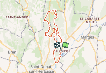
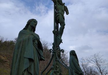
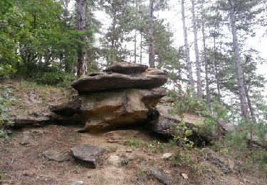
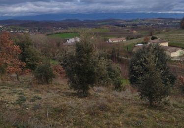
Randonnée Marche de 16,3 km à découvrir à Auvergne-Rhône-Alpes, Drôme, Saint-Donat-sur-l'Herbasse. Cette randonnée est proposée par hugo26.
Description
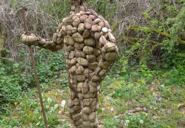
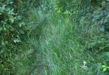
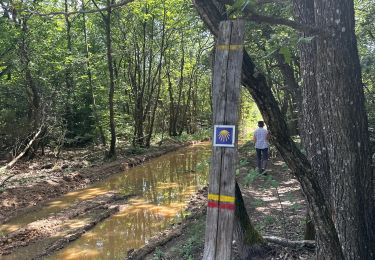
au départ du lac de champos à saint Donat rando en boucle qui passe à proximité du site Milles et une Cornes. Rando varié entre sentier chemin et route .
Localisation
Pays :
France
Région :
Auvergne-Rhône-Alpes
Département/Province :
Drôme
Commune :
Saint-Donat-sur-l'Herbasse
Localité :
Unknown
Départ:(Dec)
Départ:(UTM)
657690 ; 4999979 (31T) N.
Commentaires
Randonnées à proximité
![Randonnée Marche Bren - 26 bren 29 04 2021 - Photo](https://media.geolcdn.com/t/375/260/0cd863fd-960e-47f7-9bdd-faf5e995b7a6.jpg&format=jpg&maxdim=2)
![Marche Marche](https://static1.geolcdn.com/sitytour/trail-icons/101.png)
26 bren 29 04 2021
Marche
Facile
Bren,
Auvergne-Rhône-Alpes,
Drôme,
France
![](/images/other/stat-length.png)
17,4 km | 24 km-effort
6h 1min
![](https://static1.geolcdn.com/siteimages/upload/files/16400158638029165_repeat_loop_refresh_sync_direction_icon.png)
Non
![Randonnée Marche Crépol - 26 crepol aarthemonay pas a pas - Photo](https://media.geolcdn.com/t/375/260/6c99bf12-4c07-4347-b0d4-4b8aaac347b8.jpg&format=jpg&maxdim=2)
![Marche Marche](https://static1.geolcdn.com/sitytour/trail-icons/101.png)
26 crepol aarthemonay pas a pas
Marche
Facile
Crépol,
Auvergne-Rhône-Alpes,
Drôme,
France
![](/images/other/stat-length.png)
13,4 km | 17,6 km-effort
4h 38min
![](https://static1.geolcdn.com/siteimages/upload/files/16400158638029165_repeat_loop_refresh_sync_direction_icon.png)
Oui
![Randonnée Marche Arthémonay - Reculais 06 2024 - Photo](https://media.geolcdn.com/t/375/260/bb303910-b4b2-4d55-a4d3-11e9446d4fdb.jpg&format=jpg&maxdim=2)
![Marche Marche](https://static1.geolcdn.com/sitytour/trail-icons/101.png)
Reculais 06 2024
Marche
Difficile
Arthémonay,
Auvergne-Rhône-Alpes,
Drôme,
France
![](/images/other/stat-length.png)
11,7 km | 15,6 km-effort
3h 33min
![](https://static1.geolcdn.com/siteimages/upload/files/16400158638029165_repeat_loop_refresh_sync_direction_icon.png)
Oui
![Randonnée Marche Saint-Donat-sur-l'Herbasse - 26 st donat sizay 18 04 2021 - Photo](https://media.geolcdn.com/t/375/260/fa2afb1e-c323-4ed6-b995-4570b7209fea.jpg&format=jpg&maxdim=2)
![Marche Marche](https://static1.geolcdn.com/sitytour/trail-icons/101.png)
26 st donat sizay 18 04 2021
Marche
Facile
Saint-Donat-sur-l'Herbasse,
Auvergne-Rhône-Alpes,
Drôme,
France
![](/images/other/stat-length.png)
19,9 km | 26 km-effort
6h 20min
![](https://static1.geolcdn.com/siteimages/upload/files/16400158638029165_repeat_loop_refresh_sync_direction_icon.png)
Non
![Randonnée Marche Saint-Donat-sur-l'Herbasse - lac de champos bois de sizay - Photo](https://media.geolcdn.com/t/375/260/ext.jpg?maxdim=2&url=https%3A%2F%2Fstatic1.geolcdn.com%2Fsiteimages%2Fupload%2Ffiles%2F1553511878bg_sport_marche.png)
![Marche Marche](https://static1.geolcdn.com/sitytour/trail-icons/101.png)
lac de champos bois de sizay
Marche
Très facile
(1)
Saint-Donat-sur-l'Herbasse,
Auvergne-Rhône-Alpes,
Drôme,
France
![](/images/other/stat-length.png)
11,2 km | 14,6 km-effort
3h 1min
![](https://static1.geolcdn.com/siteimages/upload/files/16400158638029165_repeat_loop_refresh_sync_direction_icon.png)
Oui
![Randonnée Marche Saint-Donat-sur-l'Herbasse - pendillon covid - Photo](https://media.geolcdn.com/t/375/260/ext.jpg?maxdim=2&url=https%3A%2F%2Fstatic1.geolcdn.com%2Fsiteimages%2Fupload%2Ffiles%2F1553511878bg_sport_marche.png)
![Marche Marche](https://static1.geolcdn.com/sitytour/trail-icons/101.png)
pendillon covid
Marche
Très facile
(1)
Saint-Donat-sur-l'Herbasse,
Auvergne-Rhône-Alpes,
Drôme,
France
![](/images/other/stat-length.png)
8,8 km | 12,1 km-effort
1h 32min
![](https://static1.geolcdn.com/siteimages/upload/files/16400158638029165_repeat_loop_refresh_sync_direction_icon.png)
Oui
![Randonnée Marche Peyrins - peyrins - Photo](https://media.geolcdn.com/t/375/260/ext.jpg?maxdim=2&url=https%3A%2F%2Fstatic1.geolcdn.com%2Fsiteimages%2Fupload%2Ffiles%2F1553511878bg_sport_marche.png)
![Marche Marche](https://static1.geolcdn.com/sitytour/trail-icons/101.png)
peyrins
Marche
Très facile
(1)
Peyrins,
Auvergne-Rhône-Alpes,
Drôme,
France
![](/images/other/stat-length.png)
8,4 km | 11,1 km-effort
2h 53min
![](https://static1.geolcdn.com/siteimages/upload/files/16400158638029165_repeat_loop_refresh_sync_direction_icon.png)
Oui
![Randonnée Marche Saint-Donat-sur-l'Herbasse - le bois de Sizay - Photo](https://media.geolcdn.com/t/375/260/ext.jpg?maxdim=2&url=https%3A%2F%2Fservices.sitytrail.com%2FGeolivesWS%2FDownloadMedia.ashx%3FTrailID%3D224105%26Media%3Dfix__20130928165223.jpg)
![Marche Marche](https://static1.geolcdn.com/sitytour/trail-icons/101.png)
le bois de Sizay
Marche
Très facile
Saint-Donat-sur-l'Herbasse,
Auvergne-Rhône-Alpes,
Drôme,
France
![](/images/other/stat-length.png)
6,1 km | 8,6 km-effort
1h 52min
![](https://static1.geolcdn.com/siteimages/upload/files/16400158638029165_repeat_loop_refresh_sync_direction_icon.png)
Oui
![Randonnée Marche Saint-Donat-sur-l'Herbasse - 26 st donar pas a pas - Photo](https://media.geolcdn.com/t/375/260/445b6fdb-5ea9-41cd-9dc1-78408223b891.jpg&format=jpg&maxdim=2)
![Marche Marche](https://static1.geolcdn.com/sitytour/trail-icons/101.png)
26 st donar pas a pas
Marche
Très facile
Saint-Donat-sur-l'Herbasse,
Auvergne-Rhône-Alpes,
Drôme,
France
![](/images/other/stat-length.png)
10,6 km | 15,7 km-effort
3h 24min
![](https://static1.geolcdn.com/siteimages/upload/files/16400158638029165_repeat_loop_refresh_sync_direction_icon.png)
Non