![](/images/other/stat-length.png)
![Randonnée Marche Le Pouzin - les balcons de l'ouvèze - Photo](https://media.geolcdn.com/t/1900/400/ext.pjpeg?maxdim=2&url=https%3A%2F%2Fstatic1.geolcdn.com%2Fsiteimages%2Fupload%2Ffiles%2F1553511878bg_sport_marche.png)
les balcons de l'ouvèze
hugo26
Utilisateur
![Longueur](/images/other/stat-length.png)
Longueur
13,9 km
![Altitude max](https://static1.geolcdn.com/siteimages/upload/files/1508320355ic_sort_altitude_max_24dp.png)
Altitude max
375 m
![Dénivelé positif](https://static1.geolcdn.com/siteimages/upload/files/1508320355ic_sort_den_pos_24dp.png)
Dénivelé positif
605 m
![Km-Effort](/images/other/stat-length.png)
Km-Effort
22 km
![Altitude min](https://static1.geolcdn.com/siteimages/upload/files/1508320355ic_sort_altitude_min_24dp.png)
Altitude min
88 m
![Dénivelé négatif](https://static1.geolcdn.com/siteimages/upload/files/1508320355ic_sort_den_neg_24dp.png)
Dénivelé négatif
595 m
![Boucle](https://static1.geolcdn.com/siteimages/upload/files/16400158638029165_repeat_loop_refresh_sync_direction_icon.png)
Boucle
Non
Date de création :
2023-11-16 07:59:57.812
Dernière modification :
2023-11-17 06:15:32.576
![Marche](https://static1.geolcdn.com/sitytour/trail-icons/101.png)
5h39
Difficulté : Très difficile
![Scannez ce code QR pour ouvrir la randonnée dans l'application SityTrail](https://capi.geolives.com/qq0zvz2zws4bq2lad0pu/sitytour/trails/3868611/qr.png?size=200)
Application GPS de randonnée GRATUITE
À propos
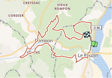
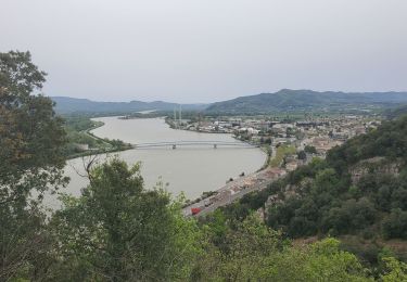
Randonnée Marche de 13,9 km à découvrir à Auvergne-Rhône-Alpes, Ardèche, Le Pouzin. Cette randonnée est proposée par hugo26.
Description
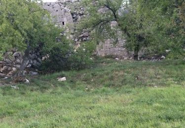
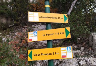
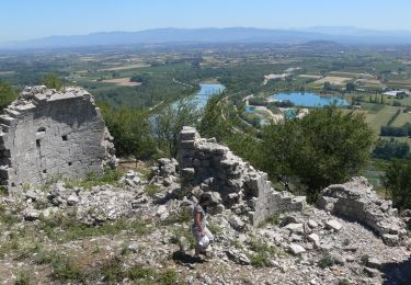
Depuis le POUZIN 07 en arrivant de l'autoroute traversez le pont et au rond point le parking est à gauche vers les arcades du chemin de fer. Très belle rando mais glissante par temps de pluie Détour au retour par le Couvent des Chèvres. Magnifiques ruines.
Localisation
Pays :
France
Région :
Auvergne-Rhône-Alpes
Département/Province :
Ardèche
Commune :
Le Pouzin
Localité :
Unknown
Départ:(Dec)
Départ:(UTM)
638486 ; 4957464 (31T) N.
Commentaires
Randonnées à proximité
![Randonnée Marche Le Pouzin - 07 balcon Ouvèze pouzin - Photo](https://media.geolcdn.com/t/375/260/e1f893af-61d3-4cd8-a418-b5cde15229b8.jpg&format=jpg&maxdim=2)
![Marche Marche](https://static1.geolcdn.com/sitytour/trail-icons/101.png)
07 balcon Ouvèze pouzin
Marche
Moyen
(1)
Le Pouzin,
Auvergne-Rhône-Alpes,
Ardèche,
France
![](/images/other/stat-length.png)
15,3 km | 24 km-effort
6h 58min
![](https://static1.geolcdn.com/siteimages/upload/files/16400158638029165_repeat_loop_refresh_sync_direction_icon.png)
Non
![Randonnée Marche La Voulte-sur-Rhône - La Voulte Via-Rhôna 7KM - Photo](https://media.geolcdn.com/t/375/260/620eea2b-7c65-44be-a1eb-b1fcfc74c039.jpg&format=jpg&maxdim=2)
![Marche Marche](https://static1.geolcdn.com/sitytour/trail-icons/101.png)
La Voulte Via-Rhôna 7KM
Marche
Moyen
(1)
La Voulte-sur-Rhône,
Auvergne-Rhône-Alpes,
Ardèche,
France
![](/images/other/stat-length.png)
6,6 km | 7,5 km-effort
1h 42min
![](https://static1.geolcdn.com/siteimages/upload/files/16400158638029165_repeat_loop_refresh_sync_direction_icon.png)
Oui
![Randonnée Marche Saint-Symphorien-sous-Chomérac - St-Symphorien-sous-Chomerac](https://media.geolcdn.com/t/375/260/b69406d1-b9d6-4e5a-81ea-edd2877facfa.jpg&format=jpg&maxdim=2)
![Marche Marche](https://static1.geolcdn.com/sitytour/trail-icons/101.png)
St-Symphorien-sous-Chomerac "Col de Linte"11km.
Marche
Difficile
(2)
Saint-Symphorien-sous-Chomérac,
Auvergne-Rhône-Alpes,
Ardèche,
France
![](/images/other/stat-length.png)
11,4 km | 15,8 km-effort
3h 35min
![](https://static1.geolcdn.com/siteimages/upload/files/16400158638029165_repeat_loop_refresh_sync_direction_icon.png)
Oui
![Randonnée Marche Le Pouzin - Le Pouzin : Couvent des Chèvres 8km. - Photo](https://media.geolcdn.com/t/375/260/3b82990a-638d-4172-b8c9-858402e07317.jpg&format=jpg&maxdim=2)
![Marche Marche](https://static1.geolcdn.com/sitytour/trail-icons/101.png)
Le Pouzin : Couvent des Chèvres 8km.
Marche
Difficile
(1)
Le Pouzin,
Auvergne-Rhône-Alpes,
Ardèche,
France
![](/images/other/stat-length.png)
8,2 km | 12,8 km-effort
2h 55min
![](https://static1.geolcdn.com/siteimages/upload/files/16400158638029165_repeat_loop_refresh_sync_direction_icon.png)
Oui
![Randonnée Marche Baix - 07 baix 07 01 23 - Photo](https://media.geolcdn.com/t/375/260/6f38ce73-6c19-4eb6-98ff-8ad86517b683.jpg&format=jpg&maxdim=2)
![Marche Marche](https://static1.geolcdn.com/sitytour/trail-icons/101.png)
07 baix 07 01 23
Marche
Moyen
Baix,
Auvergne-Rhône-Alpes,
Ardèche,
France
![](/images/other/stat-length.png)
16,5 km | 28 km-effort
7h 5min
![](https://static1.geolcdn.com/siteimages/upload/files/16400158638029165_repeat_loop_refresh_sync_direction_icon.png)
Oui
![Randonnée Marche Le Pouzin - 07 pouzin couvent des chèvres zel - Photo](https://media.geolcdn.com/t/375/260/27e3009c-a2c9-4a5b-9e79-278e69de3846.jpg&format=jpg&maxdim=2)
![Marche Marche](https://static1.geolcdn.com/sitytour/trail-icons/101.png)
07 pouzin couvent des chèvres zel
Marche
Moyen
Le Pouzin,
Auvergne-Rhône-Alpes,
Ardèche,
France
![](/images/other/stat-length.png)
15,2 km | 24 km-effort
6h 32min
![](https://static1.geolcdn.com/siteimages/upload/files/16400158638029165_repeat_loop_refresh_sync_direction_icon.png)
Oui
![Marche Marche](https://static1.geolcdn.com/sitytour/trail-icons/101.png)
Le Pouzin-Couvent des Chèvres-Gommée.15km
Marche
Très difficile
Le Pouzin,
Auvergne-Rhône-Alpes,
Ardèche,
France
![](/images/other/stat-length.png)
14,7 km | 23 km-effort
5h 13min
![](https://static1.geolcdn.com/siteimages/upload/files/16400158638029165_repeat_loop_refresh_sync_direction_icon.png)
Oui
![Randonnée Marche La Voulte-sur-Rhône - La Voulte ViaRhona 6,5km - Photo](https://media.geolcdn.com/t/375/260/9614651f-4007-44ca-9c3c-97a6e4ce7270.jpg&format=jpg&maxdim=2)
![Marche Marche](https://static1.geolcdn.com/sitytour/trail-icons/101.png)
La Voulte ViaRhona 6,5km
Marche
Facile
La Voulte-sur-Rhône,
Auvergne-Rhône-Alpes,
Ardèche,
France
![](/images/other/stat-length.png)
6,5 km | 7,5 km-effort
2h 0min
![](https://static1.geolcdn.com/siteimages/upload/files/16400158638029165_repeat_loop_refresh_sync_direction_icon.png)
Oui
![Randonnée Marche Le Pouzin - le Pouzin le couvent des Chèvres vieux Rompon - Photo](https://media.geolcdn.com/t/375/260/2a1fff91-e20b-436c-b942-1b82467f68e9.jpg&format=jpg&maxdim=2)
![Marche Marche](https://static1.geolcdn.com/sitytour/trail-icons/101.png)
le Pouzin le couvent des Chèvres vieux Rompon
Marche
Facile
Le Pouzin,
Auvergne-Rhône-Alpes,
Ardèche,
France
![](/images/other/stat-length.png)
7,9 km | 12,4 km-effort
2h 49min
![](https://static1.geolcdn.com/siteimages/upload/files/16400158638029165_repeat_loop_refresh_sync_direction_icon.png)
Oui