![](/images/other/stat-length.png)
![Randonnée Marche Ottignies-Louvain-la-Neuve - Bois-des-reves Lac de LLN - Photo](https://media.geolcdn.com/t/1900/400/ext.pjpeg?maxdim=2&url=https%3A%2F%2Fstatic1.geolcdn.com%2Fsiteimages%2Fupload%2Ffiles%2F1553511878bg_sport_marche.png)
Bois-des-reves Lac de LLN
Thyves
Utilisateur
![Longueur](/images/other/stat-length.png)
Longueur
6,9 km
![Altitude max](https://static1.geolcdn.com/siteimages/upload/files/1508320355ic_sort_altitude_max_24dp.png)
Altitude max
136 m
![Dénivelé positif](https://static1.geolcdn.com/siteimages/upload/files/1508320355ic_sort_den_pos_24dp.png)
Dénivelé positif
106 m
![Km-Effort](/images/other/stat-length.png)
Km-Effort
8,3 km
![Altitude min](https://static1.geolcdn.com/siteimages/upload/files/1508320355ic_sort_altitude_min_24dp.png)
Altitude min
68 m
![Dénivelé négatif](https://static1.geolcdn.com/siteimages/upload/files/1508320355ic_sort_den_neg_24dp.png)
Dénivelé négatif
106 m
![Boucle](https://static1.geolcdn.com/siteimages/upload/files/16400158638029165_repeat_loop_refresh_sync_direction_icon.png)
Boucle
Oui
Date de création :
2023-11-13 16:20:10.087
Dernière modification :
2023-11-19 09:37:45.188
![Marche](https://static1.geolcdn.com/sitytour/trail-icons/101.png)
1h53
Difficulté : Moyen
![Scannez ce code QR pour ouvrir la randonnée dans l'application SityTrail](https://capi.geolives.com/qq0zvz2zws4bq2lad0pu/sitytour/trails/3866243/qr.png?size=200)
Application GPS de randonnée GRATUITE
À propos
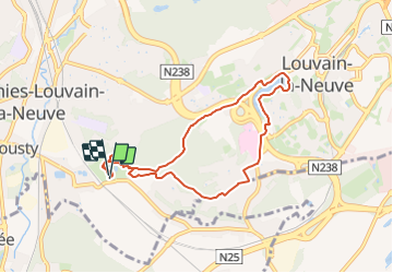
Randonnée Marche de 6,9 km à découvrir à Wallonie, Brabant wallon, Ottignies-Louvain-la-Neuve. Cette randonnée est proposée par Thyves.
Description
Promenade en boucle inspirée d'une élaborée par le Brabant Wallon, les points de départ et d'arrivée ont été modifié.
Départ du parking 1 du Bois des Rêves nous longeons l’étang du parc vers l'étang de Louvain la Neuve et retour vers le Bois des Rêves.
Localisation
Pays :
Belgique
Région :
Wallonie
Département/Province :
Brabant wallon
Commune :
Ottignies-Louvain-la-Neuve
Localité :
Unknown
Départ:(Dec)
Départ:(UTM)
611694 ; 5612960 (31U) N.
Commentaires
Randonnées à proximité
![Randonnée Marche Ottignies-Louvain-la-Neuve - Nuit du scoutisme - Louvain-la-Neuve - Photo](https://media.geolcdn.com/t/375/260/a66232ef-7471-42b4-b6aa-97b05d528647.jpg&format=jpg&maxdim=2)
![Marche Marche](https://static1.geolcdn.com/sitytour/trail-icons/101.png)
Nuit du scoutisme - Louvain-la-Neuve
Marche
Moyen
(16)
Ottignies-Louvain-la-Neuve,
Wallonie,
Brabant wallon,
Belgique
![](/images/other/stat-length.png)
5,7 km | 6,7 km-effort
1h 27min
![](https://static1.geolcdn.com/siteimages/upload/files/16400158638029165_repeat_loop_refresh_sync_direction_icon.png)
Oui
![Randonnée Marche Genappe - RB-Bw-09_Bousval_via-racc-1-et-2 - Photo](https://media.geolcdn.com/t/375/260/ext.jpg?maxdim=2&url=https%3A%2F%2Fservices.sitytrail.com%2FGeolivesWS%2FDownloadMedia.ashx%3FTrailID%3D220340%26Media%3Dd40b4c5b-4793-41f9-ac7b-fe40a955ea25.jpg)
![Marche Marche](https://static1.geolcdn.com/sitytour/trail-icons/101.png)
RB-Bw-09_Bousval_via-racc-1-et-2
Marche
Difficile
(11)
Genappe,
Wallonie,
Brabant wallon,
Belgique
![](/images/other/stat-length.png)
9,7 km | 12,5 km-effort
2h 50min
![](https://static1.geolcdn.com/siteimages/upload/files/16400158638029165_repeat_loop_refresh_sync_direction_icon.png)
Oui
![Randonnée Marche Genappe - RB-Bw-09_Bousval-via-racc-2 - Photo](https://media.geolcdn.com/t/375/260/ext.jpg?maxdim=2&url=https%3A%2F%2Fservices.sitytrail.com%2FGeolivesWS%2FDownloadMedia.ashx%3FTrailID%3D220337%26Media%3Dcacfbcff-3084-47a0-8267-9fc97c2da542.jpg)
![Marche Marche](https://static1.geolcdn.com/sitytour/trail-icons/101.png)
RB-Bw-09_Bousval-via-racc-2
Marche
Difficile
(11)
Genappe,
Wallonie,
Brabant wallon,
Belgique
![](/images/other/stat-length.png)
13,2 km | 16,9 km-effort
3h 49min
![](https://static1.geolcdn.com/siteimages/upload/files/16400158638029165_repeat_loop_refresh_sync_direction_icon.png)
Oui
![Randonnée Marche Genappe - RB-Bw-09 - Bousval - 2025-02-08 - Photo](https://media.geolcdn.com/t/375/260/ext.jpg?maxdim=2&url=https%3A%2F%2Fservices.sitytrail.com%2FGeolivesWS%2FDownloadMedia.ashx%3FTrailID%3D179584%26Media%3Dcacfbcff-3084-47a0-8267-9fc97c2da542.jpg)
![Marche Marche](https://static1.geolcdn.com/sitytour/trail-icons/101.png)
RB-Bw-09 - Bousval - 2025-02-08
Marche
Très difficile
(9)
Genappe,
Wallonie,
Brabant wallon,
Belgique
![](/images/other/stat-length.png)
22 km | 28 km-effort
6h 26min
![](https://static1.geolcdn.com/siteimages/upload/files/16400158638029165_repeat_loop_refresh_sync_direction_icon.png)
Oui
![Marche Marche](https://static1.geolcdn.com/sitytour/trail-icons/101.png)
BE-Chaumont-Gistoux - Autour de Vieusart - version courte
Marche
Moyen
(1)
Chaumont-Gistoux,
Wallonie,
Brabant wallon,
Belgique
![](/images/other/stat-length.png)
7,7 km | 9,3 km-effort
2h 6min
![](https://static1.geolcdn.com/siteimages/upload/files/16400158638029165_repeat_loop_refresh_sync_direction_icon.png)
Oui
![Randonnée Marche Chaumont-Gistoux - BE-Chaumont-Gistoux - Vieusart - Photo](https://media.geolcdn.com/t/375/260/8d29a104-ec49-41f1-a812-8df11e0d7db1.jpg&format=jpg&maxdim=2)
![Marche Marche](https://static1.geolcdn.com/sitytour/trail-icons/101.png)
BE-Chaumont-Gistoux - Vieusart
Marche
(1)
Chaumont-Gistoux,
Wallonie,
Brabant wallon,
Belgique
![](/images/other/stat-length.png)
5,6 km | 6,6 km-effort
1h 18min
![](https://static1.geolcdn.com/siteimages/upload/files/16400158638029165_repeat_loop_refresh_sync_direction_icon.png)
Oui
![Randonnée Marche Ottignies-Louvain-la-Neuve - RL-GG-02 - Céroux-Mousty - Villers-la-Ville - 2025-02-08 - Photo](https://media.geolcdn.com/t/375/260/2eead39d-9522-4a6a-a4f3-f791e0a7304a.jpg&format=jpg&maxdim=2)
![Marche Marche](https://static1.geolcdn.com/sitytour/trail-icons/101.png)
RL-GG-02 - Céroux-Mousty - Villers-la-Ville - 2025-02-08
Marche
Très difficile
(4)
Ottignies-Louvain-la-Neuve,
Wallonie,
Brabant wallon,
Belgique
![](/images/other/stat-length.png)
20 km | 26 km-effort
5h 55min
![](https://static1.geolcdn.com/siteimages/upload/files/16400158638029165_repeat_loop_refresh_sync_direction_icon.png)
Non
![Randonnée Marche Mont-Saint-Guibert - Balade à Mont-Saint-Guibert - Photo](https://media.geolcdn.com/t/375/260/ext.jpg?maxdim=2&url=https%3A%2F%2Fservices.sitytrail.com%2FGeolivesWS%2FDownloadMedia.ashx%3FTrailID%3D942864%26Media%3D4a857fe0-cf43-4eb8-b563-62b2b90d4fc2.jpg)
![Marche Marche](https://static1.geolcdn.com/sitytour/trail-icons/101.png)
Balade à Mont-Saint-Guibert
Marche
Très facile
(2)
Mont-Saint-Guibert,
Wallonie,
Brabant wallon,
Belgique
![](/images/other/stat-length.png)
8,4 km | 10,1 km-effort
2h 12min
![](https://static1.geolcdn.com/siteimages/upload/files/16400158638029165_repeat_loop_refresh_sync_direction_icon.png)
Oui
![Randonnée Marche Ottignies-Louvain-la-Neuve - Balade dans le Bois de Lauzelle - Photo](https://media.geolcdn.com/t/375/260/ext.jpg?maxdim=2&url=https%3A%2F%2Fservices.sitytrail.com%2FGeolivesWS%2FDownloadMedia.ashx%3FTrailID%3D652718%26Media%3Dfe46824b-6e61-4100-b5d8-1f34a923c154.jpg)
![Marche Marche](https://static1.geolcdn.com/sitytour/trail-icons/101.png)
Balade dans le Bois de Lauzelle
Marche
Très facile
(1)
Ottignies-Louvain-la-Neuve,
Wallonie,
Brabant wallon,
Belgique
![](/images/other/stat-length.png)
6,3 km | 8,1 km-effort
1h 44min
![](https://static1.geolcdn.com/siteimages/upload/files/16400158638029165_repeat_loop_refresh_sync_direction_icon.png)
Oui