![](/images/other/stat-length.png)
![Randonnée Marche Fromentières - Chatrau Gontier - Photo](https://media.geolcdn.com/t/1900/400/5c3100e5-55d2-4c3f-861f-c80ab98e2af3.jpg&format=pjpeg&maxdim=2)
Chatrau Gontier
Axelloceane
Utilisateur
![Longueur](/images/other/stat-length.png)
Longueur
7,6 km
![Altitude max](https://static1.geolcdn.com/siteimages/upload/files/1508320355ic_sort_altitude_max_24dp.png)
Altitude max
60 m
![Dénivelé positif](https://static1.geolcdn.com/siteimages/upload/files/1508320355ic_sort_den_pos_24dp.png)
Dénivelé positif
92 m
![Km-Effort](/images/other/stat-length.png)
Km-Effort
8,9 km
![Altitude min](https://static1.geolcdn.com/siteimages/upload/files/1508320355ic_sort_altitude_min_24dp.png)
Altitude min
26 m
![Dénivelé négatif](https://static1.geolcdn.com/siteimages/upload/files/1508320355ic_sort_den_neg_24dp.png)
Dénivelé négatif
91 m
![Boucle](https://static1.geolcdn.com/siteimages/upload/files/16400158638029165_repeat_loop_refresh_sync_direction_icon.png)
Boucle
Oui
Date de création :
2023-11-12 14:34:59.597
Dernière modification :
2024-04-01 17:29:54.82
![Marche](https://static1.geolcdn.com/sitytour/trail-icons/101.png)
2h00
Difficulté : Moyen
![Scannez ce code QR pour ouvrir la randonnée dans l'application SityTrail](https://capi.geolives.com/qq0zvz2zws4bq2lad0pu/sitytour/trails/3865286/qr.png?size=200)
Application GPS de randonnée GRATUITE
À propos
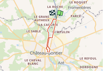
Randonnée Marche de 7,6 km à découvrir à Pays de la Loire, Mayenne, Fromentières. Cette randonnée est proposée par Axelloceane.
Description
Départ du pont traversant la mayenne ,ensuite suivre le halage jusqu'à Chateau Gontier .Puis retour en suivant la Mayenne et le sentier longeant la route .
Localisation
Pays :
France
Région :
Pays de la Loire
Département/Province :
Mayenne
Commune :
Fromentières
Localité :
Unknown
Départ:(Dec)
Départ:(UTM)
672461 ; 5302592 (30T) N.
Commentaires
Randonnées à proximité
![Randonnée Marche Château-Gontier-sur-Mayenne - Circuit du Moulinet au départ de Bazouges (n°1) - Photo](https://media.geolcdn.com/t/375/260/ext.jpg?maxdim=2&url=https%3A%2F%2Fstatic1.geolcdn.com%2Fsiteimages%2Fupload%2Ffiles%2F1553511878bg_sport_marche.png)
![Marche Marche](https://static1.geolcdn.com/sitytour/trail-icons/101.png)
Circuit du Moulinet au départ de Bazouges (n°1)
Marche
Moyen
Château-Gontier-sur-Mayenne,
Pays de la Loire,
Mayenne,
France
![](/images/other/stat-length.png)
8,9 km | 10,3 km-effort
2h 20min
![](https://static1.geolcdn.com/siteimages/upload/files/16400158638029165_repeat_loop_refresh_sync_direction_icon.png)
Oui
![Randonnée Vélo Château-Gontier-sur-Mayenne - VOIE VERTE CHATEAU-GONTIER – SEGRÉ - Photo](https://media.geolcdn.com/t/375/260/ext.jpg?maxdim=2&url=https%3A%2F%2Fstatic1.geolcdn.com%2Fsiteimages%2Fupload%2Ffiles%2F1524743154velo.jpg)
![Vélo Vélo](https://static1.geolcdn.com/sitytour/trail-icons/200.png)
VOIE VERTE CHATEAU-GONTIER – SEGRÉ
Vélo
Facile
Château-Gontier-sur-Mayenne,
Pays de la Loire,
Mayenne,
France
![](/images/other/stat-length.png)
23 km | 25 km-effort
1h 30min
![](https://static1.geolcdn.com/siteimages/upload/files/16400158638029165_repeat_loop_refresh_sync_direction_icon.png)
Non
![Randonnée Marche Château-Gontier-sur-Mayenne - Circuit des Perrettes - Photo](https://media.geolcdn.com/t/375/260/ext.jpg?maxdim=2&url=https%3A%2F%2Fstatic1.geolcdn.com%2Fsiteimages%2Fupload%2Ffiles%2F1553511878bg_sport_marche.png)
![Marche Marche](https://static1.geolcdn.com/sitytour/trail-icons/101.png)
Circuit des Perrettes
Marche
Moyen
Château-Gontier-sur-Mayenne,
Pays de la Loire,
Mayenne,
France
![](/images/other/stat-length.png)
5,4 km | 6,6 km-effort
1h 30min
![](https://static1.geolcdn.com/siteimages/upload/files/16400158638029165_repeat_loop_refresh_sync_direction_icon.png)
Oui
![Randonnée V.T.T. Château-Gontier-sur-Mayenne - F.ChateauGontierPontsDeCéJ5/14 - Photo](https://media.geolcdn.com/t/375/260/ext.jpg?maxdim=2&url=https%3A%2F%2Fstatic1.geolcdn.com%2Fsiteimages%2Fupload%2Ffiles%2F1524743154velo.jpg)
![V.T.T. V.T.T.](https://static1.geolcdn.com/sitytour/trail-icons/202.png)
F.ChateauGontierPontsDeCéJ5/14
V.T.T.
Très facile
Château-Gontier-sur-Mayenne,
Pays de la Loire,
Mayenne,
France
![](/images/other/stat-length.png)
82 km | 92 km-effort
5min
![](https://static1.geolcdn.com/siteimages/upload/files/16400158638029165_repeat_loop_refresh_sync_direction_icon.png)
Non
![Randonnée Marche Château-Gontier-sur-Mayenne - Azé - Château-Gontier - Photo](https://media.geolcdn.com/t/375/260/ext.jpg?maxdim=2&url=https%3A%2F%2Fstatic1.geolcdn.com%2Fsiteimages%2Fupload%2Ffiles%2F1553511878bg_sport_marche.png)
![Marche Marche](https://static1.geolcdn.com/sitytour/trail-icons/101.png)
Azé - Château-Gontier
Marche
Moyen
Château-Gontier-sur-Mayenne,
Pays de la Loire,
Mayenne,
France
![](/images/other/stat-length.png)
18 km | 20 km-effort
5h 0min
![](https://static1.geolcdn.com/siteimages/upload/files/16400158638029165_repeat_loop_refresh_sync_direction_icon.png)
Oui
![Randonnée V.T.T. Château-Gontier-sur-Mayenne - BandaDelCucu6 - Photo](https://media.geolcdn.com/t/375/260/ext.jpg?maxdim=2&url=https%3A%2F%2Fstatic1.geolcdn.com%2Fsiteimages%2Fupload%2Ffiles%2F1524743154velo.jpg)
![V.T.T. V.T.T.](https://static1.geolcdn.com/sitytour/trail-icons/202.png)
BandaDelCucu6
V.T.T.
Très facile
Château-Gontier-sur-Mayenne,
Pays de la Loire,
Mayenne,
France
![](/images/other/stat-length.png)
57 km | 64 km-effort
3h 40min
![](https://static1.geolcdn.com/siteimages/upload/files/16400158638029165_repeat_loop_refresh_sync_direction_icon.png)
Non
![Randonnée Cyclotourisme Château-Gontier-sur-Mayenne - Vélofrancette - Tronçon 3 - Photo](https://media.geolcdn.com/t/375/260/ext.jpg?maxdim=2&url=https%3A%2F%2Fstatic1.geolcdn.com%2Fsiteimages%2Fupload%2Ffiles%2F1524743154velo.jpg)
![Cyclotourisme Cyclotourisme](https://static1.geolcdn.com/sitytour/trail-icons/204.png)
Vélofrancette - Tronçon 3
Cyclotourisme
Très facile
Château-Gontier-sur-Mayenne,
Pays de la Loire,
Mayenne,
France
![](/images/other/stat-length.png)
145 km | 162 km-effort
Inconnu
![](https://static1.geolcdn.com/siteimages/upload/files/16400158638029165_repeat_loop_refresh_sync_direction_icon.png)
Non
![Randonnée V.T.T. Château-Gontier-sur-Mayenne - prepa 2 rando vtt chateau gontier sud - Photo](https://media.geolcdn.com/t/375/260/ext.jpg?maxdim=2&url=https%3A%2F%2Fstatic1.geolcdn.com%2Fsiteimages%2Fupload%2Ffiles%2F1524743154velo.jpg)
![V.T.T. V.T.T.](https://static1.geolcdn.com/sitytour/trail-icons/202.png)
prepa 2 rando vtt chateau gontier sud
V.T.T.
Très difficile
Château-Gontier-sur-Mayenne,
Pays de la Loire,
Mayenne,
France
![](/images/other/stat-length.png)
64 km | 72 km-effort
4h 58min
![](https://static1.geolcdn.com/siteimages/upload/files/16400158638029165_repeat_loop_refresh_sync_direction_icon.png)
Oui
![Randonnée V.T.T. Château-Gontier-sur-Mayenne - prepa tracé rando vtt Chateau gontier - Photo](https://media.geolcdn.com/t/375/260/ext.jpg?maxdim=2&url=https%3A%2F%2Fstatic1.geolcdn.com%2Fsiteimages%2Fupload%2Ffiles%2F1524743154velo.jpg)
![V.T.T. V.T.T.](https://static1.geolcdn.com/sitytour/trail-icons/202.png)
prepa tracé rando vtt Chateau gontier
V.T.T.
Très difficile
Château-Gontier-sur-Mayenne,
Pays de la Loire,
Mayenne,
France
![](/images/other/stat-length.png)
73 km | 83 km-effort
5h 45min
![](https://static1.geolcdn.com/siteimages/upload/files/16400158638029165_repeat_loop_refresh_sync_direction_icon.png)
Oui