![](/images/other/stat-length.png)
![Randonnée V.T.T. Theizé - Vtt Theizé Les Allognières Remont, St Clair, Le Peineau, St Abram - Photo](https://media.geolcdn.com/t/1900/400/ext.pjpeg?maxdim=2&url=https%3A%2F%2Fstatic1.geolcdn.com%2Fsiteimages%2Fupload%2Ffiles%2F1524743154velo.jpg)
Vtt Theizé Les Allognières Remont, St Clair, Le Peineau, St Abram
Mariolebeno
Utilisateur
![Longueur](/images/other/stat-length.png)
Longueur
17 km
![Altitude max](https://static1.geolcdn.com/siteimages/upload/files/1508320355ic_sort_altitude_max_24dp.png)
Altitude max
650 m
![Dénivelé positif](https://static1.geolcdn.com/siteimages/upload/files/1508320355ic_sort_den_pos_24dp.png)
Dénivelé positif
546 m
![Km-Effort](/images/other/stat-length.png)
Km-Effort
24 km
![Altitude min](https://static1.geolcdn.com/siteimages/upload/files/1508320355ic_sort_altitude_min_24dp.png)
Altitude min
423 m
![Dénivelé négatif](https://static1.geolcdn.com/siteimages/upload/files/1508320355ic_sort_den_neg_24dp.png)
Dénivelé négatif
546 m
![Boucle](https://static1.geolcdn.com/siteimages/upload/files/16400158638029165_repeat_loop_refresh_sync_direction_icon.png)
Boucle
Oui
Date de création :
2023-11-05 14:09:37.039
Dernière modification :
2023-11-10 15:14:32.674
![V.T.T.](https://static1.geolcdn.com/sitytour/trail-icons/202.png)
1h41
Difficulté : Moyen
![Scannez ce code QR pour ouvrir la randonnée dans l'application SityTrail](https://capi.geolives.com/qq0zvz2zws4bq2lad0pu/sitytour/trails/3859358/qr.png?size=200)
Application GPS de randonnée GRATUITE
À propos
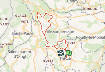
Randonnée V.T.T. de 17 km à découvrir à Auvergne-Rhône-Alpes, Rhône, Theizé. Cette randonnée est proposée par Mariolebeno.
Description
La Montée des Allognières par le versant Sud est reservée aux costauds (je pousse une bonne partie).
la montée des Grands Vières est un peu caillouteuse, mais ça passe.
Localisation
Pays :
France
Région :
Auvergne-Rhône-Alpes
Département/Province :
Rhône
Commune :
Theizé
Localité :
Unknown
Départ:(Dec)
Départ:(UTM)
625248 ; 5088553 (31T) N.
Commentaires
Randonnées à proximité
![Randonnée Marche Val d'Oingt - Oingt (69) Beaujolais - Photo](https://media.geolcdn.com/t/375/260/ext.jpg?maxdim=2&url=https%3A%2F%2Fservices.sitytrail.com%2FGeolivesWS%2FDownloadMedia.ashx%3FTrailID%3D717640%26Media%3D20161208145812.jpg)
![Marche Marche](https://static1.geolcdn.com/sitytour/trail-icons/101.png)
Oingt (69) Beaujolais
Marche
Très facile
(1)
Val d'Oingt,
Auvergne-Rhône-Alpes,
Rhône,
France
![](/images/other/stat-length.png)
9,3 km | 13,3 km-effort
2h 30min
![](https://static1.geolcdn.com/siteimages/upload/files/16400158638029165_repeat_loop_refresh_sync_direction_icon.png)
Oui
![Randonnée A pied Légny - De Saint Vérand à Bagnols - Photo](https://media.geolcdn.com/t/375/260/ext.jpg?maxdim=2&url=https%3A%2F%2Fmedia.geolcdn.com%2Ff%2F8977dfd0-d2ce-47f1-865f-122546f4dda1.jpeg)
![A pied A pied](https://static1.geolcdn.com/sitytour/trail-icons/100.png)
De Saint Vérand à Bagnols
A pied
Facile
Légny,
Auvergne-Rhône-Alpes,
Rhône,
France
![](/images/other/stat-length.png)
7,4 km | 10,3 km-effort
2h 20min
![](https://static1.geolcdn.com/siteimages/upload/files/16400158638029165_repeat_loop_refresh_sync_direction_icon.png)
Non
![Randonnée Marche nordique Bagnols - bagnol - Photo](https://media.geolcdn.com/t/375/260/ext.jpg?maxdim=2&url=https%3A%2F%2Fstatic1.geolcdn.com%2Fsiteimages%2Fupload%2Ffiles%2F1545311037marcheuse_200dpi.jpg)
![Marche nordique Marche nordique](https://static1.geolcdn.com/sitytour/trail-icons/102.png)
bagnol
Marche nordique
Très facile
(1)
Bagnols,
Auvergne-Rhône-Alpes,
Rhône,
France
![](/images/other/stat-length.png)
6,8 km | 8,4 km-effort
1h 40min
![](https://static1.geolcdn.com/siteimages/upload/files/16400158638029165_repeat_loop_refresh_sync_direction_icon.png)
Oui
![Randonnée Vélo électrique Val d'Oingt - tour dans le beaujolais Oingt - Salles sur Arbuissonnas - Photo](https://media.geolcdn.com/t/375/260/ext.jpg?maxdim=2&url=https%3A%2F%2Fstatic1.geolcdn.com%2Fsiteimages%2Fupload%2Ffiles%2F1524743154velo.jpg)
![Vélo électrique Vélo électrique](https://static1.geolcdn.com/sitytour/trail-icons/205.png)
tour dans le beaujolais Oingt - Salles sur Arbuissonnas
Vélo électrique
Moyen
(1)
Val d'Oingt,
Auvergne-Rhône-Alpes,
Rhône,
France
![](/images/other/stat-length.png)
52 km | 68 km-effort
5h 44min
![](https://static1.geolcdn.com/siteimages/upload/files/16400158638029165_repeat_loop_refresh_sync_direction_icon.png)
Oui
![Randonnée Marche Sainte-Paule - Sainte-Paule (13,4 km D. 485 m) - Photo](https://media.geolcdn.com/t/375/260/ext.jpg?maxdim=2&url=https%3A%2F%2Fstatic1.geolcdn.com%2Fsiteimages%2Fupload%2Ffiles%2F1553511878bg_sport_marche.png)
![Marche Marche](https://static1.geolcdn.com/sitytour/trail-icons/101.png)
Sainte-Paule (13,4 km D. 485 m)
Marche
Moyen
(1)
Sainte-Paule,
Auvergne-Rhône-Alpes,
Rhône,
France
![](/images/other/stat-length.png)
13,4 km | 19,4 km-effort
4h 9min
![](https://static1.geolcdn.com/siteimages/upload/files/16400158638029165_repeat_loop_refresh_sync_direction_icon.png)
Oui
![Randonnée Marche Val d'Oingt - Saint-Laurent d'Oingt - Oingt, Plus beau Village de France - Photo](https://media.geolcdn.com/t/375/260/ext.jpg?maxdim=2&url=https%3A%2F%2Fmedia.geolcdn.com%2Ff%2F9de88858-516e-46c1-be54-ecde0c6ac62c.JPG)
![Marche Marche](https://static1.geolcdn.com/sitytour/trail-icons/101.png)
Saint-Laurent d'Oingt - Oingt, Plus beau Village de France
Marche
Difficile
Val d'Oingt,
Auvergne-Rhône-Alpes,
Rhône,
France
![](/images/other/stat-length.png)
8,8 km | 12,5 km-effort
2h 20min
![](https://static1.geolcdn.com/siteimages/upload/files/16400158638029165_repeat_loop_refresh_sync_direction_icon.png)
Oui
![Randonnée Marche Val d'Oingt - 69620-Saint-Laurent d'Oingt-Bois d'Oingt : lavoirs, château et coteaux - Photo](https://media.geolcdn.com/t/375/260/ext.jpg?maxdim=2&url=https%3A%2F%2Fmedia.geolcdn.com%2Ff%2Ff3b7e635-4f2d-4ecb-b5c7-b81cf631e86a.jpg)
![Marche Marche](https://static1.geolcdn.com/sitytour/trail-icons/101.png)
69620-Saint-Laurent d'Oingt-Bois d'Oingt : lavoirs, château et coteaux
Marche
Moyen
Val d'Oingt,
Auvergne-Rhône-Alpes,
Rhône,
France
![](/images/other/stat-length.png)
8 km | 11 km-effort
1h 57min
![](https://static1.geolcdn.com/siteimages/upload/files/16400158638029165_repeat_loop_refresh_sync_direction_icon.png)
Oui
![Randonnée Marche Theizé - Theizé (11 km - D. 310 m) - Photo](https://media.geolcdn.com/t/375/260/ext.jpg?maxdim=2&url=https%3A%2F%2Fmedia.geolcdn.com%2Ff%2F3ec616fb-11b1-40f1-9452-df22023aec06.jpeg)
![Marche Marche](https://static1.geolcdn.com/sitytour/trail-icons/101.png)
Theizé (11 km - D. 310 m)
Marche
Moyen
Theizé,
Auvergne-Rhône-Alpes,
Rhône,
France
![](/images/other/stat-length.png)
11,3 km | 15,5 km-effort
2h 43min
![](https://static1.geolcdn.com/siteimages/upload/files/16400158638029165_repeat_loop_refresh_sync_direction_icon.png)
Oui
![Randonnée Marche Val d'Oingt - Oingt en Beaujolais (13 km - D. 405 m) - Photo](https://media.geolcdn.com/t/375/260/ext.jpg?maxdim=2&url=https%3A%2F%2Fmedia.geolcdn.com%2Ff%2F59dcc692-b3dd-4f1e-9301-7aedae307d94.jpg)
![Marche Marche](https://static1.geolcdn.com/sitytour/trail-icons/101.png)
Oingt en Beaujolais (13 km - D. 405 m)
Marche
Moyen
Val d'Oingt,
Auvergne-Rhône-Alpes,
Rhône,
France
![](/images/other/stat-length.png)
13,4 km | 18,8 km-effort
4h 58min
![](https://static1.geolcdn.com/siteimages/upload/files/16400158638029165_repeat_loop_refresh_sync_direction_icon.png)
Oui