![](/images/other/stat-length.png)
![Randonnée Marche L'Houmeau - la Rochelle - Photo](https://media.geolcdn.com/t/1900/400/3c3bbb21-7992-4371-a02f-d923fcb33e8b.jpg&format=pjpeg&maxdim=2)
la Rochelle
jpipacific
Utilisateur
![Longueur](/images/other/stat-length.png)
Longueur
5,5 km
![Altitude max](https://static1.geolcdn.com/siteimages/upload/files/1508320355ic_sort_altitude_max_24dp.png)
Altitude max
14 m
![Dénivelé positif](https://static1.geolcdn.com/siteimages/upload/files/1508320355ic_sort_den_pos_24dp.png)
Dénivelé positif
26 m
![Km-Effort](/images/other/stat-length.png)
Km-Effort
5,8 km
![Altitude min](https://static1.geolcdn.com/siteimages/upload/files/1508320355ic_sort_altitude_min_24dp.png)
Altitude min
-2 m
![Dénivelé négatif](https://static1.geolcdn.com/siteimages/upload/files/1508320355ic_sort_den_neg_24dp.png)
Dénivelé négatif
26 m
![Boucle](https://static1.geolcdn.com/siteimages/upload/files/16400158638029165_repeat_loop_refresh_sync_direction_icon.png)
Boucle
Oui
Date de création :
2023-11-01 16:13:05.356
Dernière modification :
2023-11-08 09:03:39.823
![Marche](https://static1.geolcdn.com/sitytour/trail-icons/101.png)
1h30
Difficulté : Très facile
![Scannez ce code QR pour ouvrir la randonnée dans l'application SityTrail](https://capi.geolives.com/qq0zvz2zws4bq2lad0pu/sitytour/trails/3856452/qr.png?size=200)
Application GPS de randonnée GRATUITE
À propos
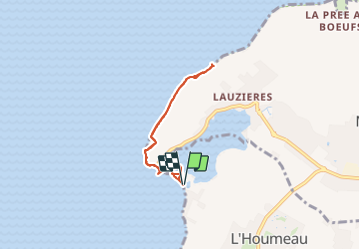
Randonnée Marche de 5,5 km à découvrir à Nouvelle-Aquitaine, Charente-Maritime, L'Houmeau. Cette randonnée est proposée par jpipacific.
Description
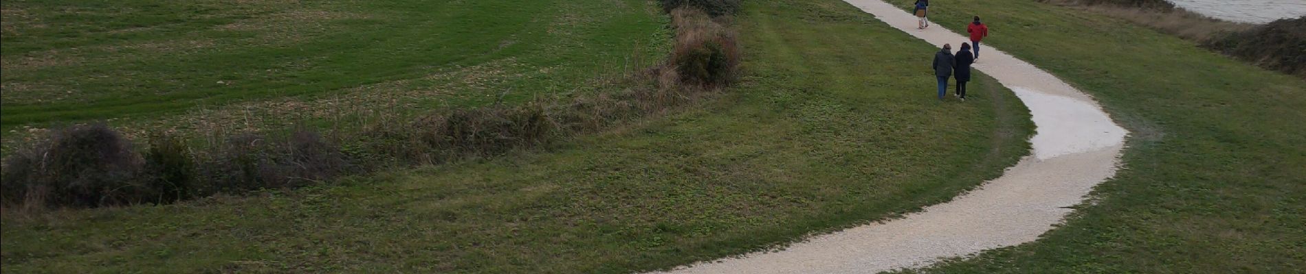
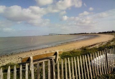
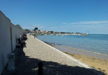
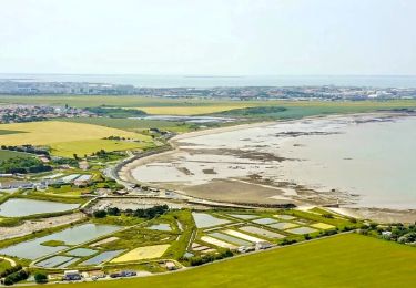
Balade en bord de mer organisée par Lulu.
Pas de difficulté. Vu sur l'ile de Ré et le pont.
Beaucoup de vent et un peu de pluie. Vivifiant !
Localisation
Pays :
France
Région :
Nouvelle-Aquitaine
Département/Province :
Charente-Maritime
Commune :
L'Houmeau
Localité :
Unknown
Départ:(Dec)
Départ:(UTM)
638909 ; 5117857 (30T) N.
Commentaires
Randonnées à proximité
![Randonnée Marche Rivedoux-Plage - Sentier du littoral - Rivedoux-Plage - Photo](https://media.geolcdn.com/t/375/260/ext.jpg?maxdim=2&url=https%3A%2F%2Fservices.sitytrail.com%2FGeolivesWS%2FDownloadMedia.ashx%3FTrailID%3D191591%26Media%3D15221_6.jpg)
![Marche Marche](https://static1.geolcdn.com/sitytour/trail-icons/101.png)
Sentier du littoral - Rivedoux-Plage
Marche
Moyen
(1)
Rivedoux-Plage,
Nouvelle-Aquitaine,
Charente-Maritime,
France
![](/images/other/stat-length.png)
10,8 km | 11,6 km-effort
2h 30min
![](https://static1.geolcdn.com/siteimages/upload/files/16400158638029165_repeat_loop_refresh_sync_direction_icon.png)
Oui
![Randonnée Marche Rivedoux-Plage - Les Gros Peux - Rivedoux - Photo](https://media.geolcdn.com/t/375/260/ext.jpg?maxdim=2&url=https%3A%2F%2Fservices.sitytrail.com%2FGeolivesWS%2FDownloadMedia.ashx%3FTrailID%3D191590%26Media%3D15220_6.jpg)
![Marche Marche](https://static1.geolcdn.com/sitytour/trail-icons/101.png)
Les Gros Peux - Rivedoux
Marche
Facile
(5)
Rivedoux-Plage,
Nouvelle-Aquitaine,
Charente-Maritime,
France
![](/images/other/stat-length.png)
6,4 km | 6,8 km-effort
1h 30min
![](https://static1.geolcdn.com/siteimages/upload/files/16400158638029165_repeat_loop_refresh_sync_direction_icon.png)
Oui
![Randonnée Vélo La Rochelle - la rochelle - Photo](https://media.geolcdn.com/t/375/260/ext.jpg?maxdim=2&url=https%3A%2F%2Fstatic1.geolcdn.com%2Fsiteimages%2Fupload%2Ffiles%2F1524743154velo.jpg)
![Vélo Vélo](https://static1.geolcdn.com/sitytour/trail-icons/200.png)
la rochelle
Vélo
Très facile
(1)
La Rochelle,
Nouvelle-Aquitaine,
Charente-Maritime,
France
![](/images/other/stat-length.png)
16,2 km | 17,5 km-effort
2h 17min
![](https://static1.geolcdn.com/siteimages/upload/files/16400158638029165_repeat_loop_refresh_sync_direction_icon.png)
Oui
![Randonnée A pied Rivedoux-Plage - Sentier du littoral - Photo](https://media.geolcdn.com/t/375/260/f34a5b01-8068-4aba-b707-54b730f52756.jpeg&format=jpg&maxdim=2)
![A pied A pied](https://static1.geolcdn.com/sitytour/trail-icons/100.png)
Sentier du littoral
A pied
Facile
Rivedoux-Plage,
Nouvelle-Aquitaine,
Charente-Maritime,
France
![](/images/other/stat-length.png)
10,6 km | 11,5 km-effort
2h 36min
![](https://static1.geolcdn.com/siteimages/upload/files/16400158638029165_repeat_loop_refresh_sync_direction_icon.png)
Non
![Randonnée Marche Rivedoux-Plage - Ile de Ré-La Flotte Rivedoux - Photo](https://media.geolcdn.com/t/375/260/ext.jpg?maxdim=2&url=https%3A%2F%2Fservices.sitytrail.com%2FGeolivesWS%2FDownloadMedia.ashx%3FTrailID%3D310151%26Media%3Dfix__20140607134515.jpg)
![Marche Marche](https://static1.geolcdn.com/sitytour/trail-icons/101.png)
Ile de Ré-La Flotte Rivedoux
Marche
Facile
Rivedoux-Plage,
Nouvelle-Aquitaine,
Charente-Maritime,
France
![](/images/other/stat-length.png)
21 km | 23 km-effort
4h 24min
![](https://static1.geolcdn.com/siteimages/upload/files/16400158638029165_repeat_loop_refresh_sync_direction_icon.png)
Non
![Randonnée Marche Lagord - Nieul_Terre_Mer - Photo](https://media.geolcdn.com/t/375/260/9d212f40-6824-464e-8d1e-e93e2b9b5c5e.jpg&format=jpg&maxdim=2)
![Marche Marche](https://static1.geolcdn.com/sitytour/trail-icons/101.png)
Nieul_Terre_Mer
Marche
Moyen
Lagord,
Nouvelle-Aquitaine,
Charente-Maritime,
France
![](/images/other/stat-length.png)
15,5 km | 16,6 km-effort
4h 45min
![](https://static1.geolcdn.com/siteimages/upload/files/16400158638029165_repeat_loop_refresh_sync_direction_icon.png)
Oui
![Randonnée Marche La Rochelle - 21-09-2024 Boucle la Rochelle (journée patrimoine) - Photo](https://media.geolcdn.com/t/375/260/87e3f1cc-f691-452b-b046-b2fa4978e87f.jpg&format=jpg&maxdim=2)
![Marche Marche](https://static1.geolcdn.com/sitytour/trail-icons/101.png)
21-09-2024 Boucle la Rochelle (journée patrimoine)
Marche
Moyen
La Rochelle,
Nouvelle-Aquitaine,
Charente-Maritime,
France
![](/images/other/stat-length.png)
7,5 km | 8,1 km-effort
1h 44min
![](https://static1.geolcdn.com/siteimages/upload/files/16400158638029165_repeat_loop_refresh_sync_direction_icon.png)
Oui
![Randonnée Marche La Rochelle - la Rochelle - Photo](https://media.geolcdn.com/t/375/260/bee0954c-7523-4cce-8e2f-85ad76c4e573.jpg&format=jpg&maxdim=2)
![Marche Marche](https://static1.geolcdn.com/sitytour/trail-icons/101.png)
la Rochelle
Marche
Très facile
La Rochelle,
Nouvelle-Aquitaine,
Charente-Maritime,
France
![](/images/other/stat-length.png)
17,8 km | 19,4 km-effort
4h 30min
![](https://static1.geolcdn.com/siteimages/upload/files/16400158638029165_repeat_loop_refresh_sync_direction_icon.png)
Oui
![Randonnée Marche L'Houmeau - NIEUL - Photo](https://media.geolcdn.com/t/375/260/ext.jpg?maxdim=2&url=https%3A%2F%2Fstatic1.geolcdn.com%2Fsiteimages%2Fupload%2Ffiles%2F1553511878bg_sport_marche.png)
![Marche Marche](https://static1.geolcdn.com/sitytour/trail-icons/101.png)
NIEUL
Marche
Moyen
L'Houmeau,
Nouvelle-Aquitaine,
Charente-Maritime,
France
![](/images/other/stat-length.png)
8 km | 8,5 km-effort
1h 56min
![](https://static1.geolcdn.com/siteimages/upload/files/16400158638029165_repeat_loop_refresh_sync_direction_icon.png)
Oui