![](/images/other/stat-length.png)
![Randonnée Marche Syam - Jura J5 G1 - La Grande Cheminée - Chaux des Crotenay - Belvédère - Le Col du Gyps 17 km 620 m - Photo](https://media.geolcdn.com/t/1900/400/ext.pjpeg?maxdim=2&url=https%3A%2F%2Fstatic1.geolcdn.com%2Fsiteimages%2Fupload%2Ffiles%2F1553511878bg_sport_marche.png)
Jura J5 G1 - La Grande Cheminée - Chaux des Crotenay - Belvédère - Le Col du Gyps 17 km 620 m
Les 1000 pattes
Club randonnées SERVON
![Longueur](/images/other/stat-length.png)
Longueur
17,1 km
![Altitude max](https://static1.geolcdn.com/siteimages/upload/files/1508320355ic_sort_altitude_max_24dp.png)
Altitude max
899 m
![Dénivelé positif](https://static1.geolcdn.com/siteimages/upload/files/1508320355ic_sort_den_pos_24dp.png)
Dénivelé positif
619 m
![Km-Effort](/images/other/stat-length.png)
Km-Effort
25 km
![Altitude min](https://static1.geolcdn.com/siteimages/upload/files/1508320355ic_sort_altitude_min_24dp.png)
Altitude min
531 m
![Dénivelé négatif](https://static1.geolcdn.com/siteimages/upload/files/1508320355ic_sort_den_neg_24dp.png)
Dénivelé négatif
620 m
![Boucle](https://static1.geolcdn.com/siteimages/upload/files/16400158638029165_repeat_loop_refresh_sync_direction_icon.png)
Boucle
Oui
Date de création :
2023-10-27 14:45:20.129
Dernière modification :
2024-05-02 13:52:03.872
![Marche](https://static1.geolcdn.com/sitytour/trail-icons/101.png)
5h45
Difficulté : Très difficile
![Scannez ce code QR pour ouvrir la randonnée dans l'application SityTrail](https://capi.geolives.com/qq0zvz2zws4bq2lad0pu/sitytour/trails/3851785/qr.png?size=200)
Application GPS de randonnée GRATUITE
À propos
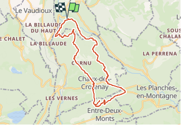
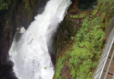
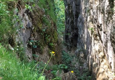
Randonnée Marche de 17,1 km à découvrir à Bourgogne-Franche-Comté, Jura, Syam. Cette randonnée est proposée par Les 1000 pattes.
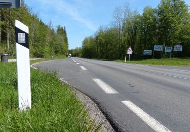
Description
Parking Waze :
"D279 Syam 39300"
Parking à doite après le Pont de la Saine sur la RD279 (une fois passé le village de Syam)
Trajet aller 23 km 25 min
Localisation
Pays :
France
Région :
Bourgogne-Franche-Comté
Département/Province :
Jura
Commune :
Syam
Localité :
Unknown
Départ:(Dec)
Départ:(UTM)
725343 ; 5174799 (31T) N.
Commentaires
Randonnées à proximité
![Randonnée Marche Les Planches-en-Montagne - Gorges de la Saine - Les Planches en Montagne - Photo](https://media.geolcdn.com/t/375/260/ext.jpg?maxdim=2&url=https%3A%2F%2Fservices.sitytrail.com%2FGeolivesWS%2FDownloadMedia.ashx%3FTrailID%3D317645%26Media%3D16918_6.jpg)
![Marche Marche](https://static1.geolcdn.com/sitytour/trail-icons/101.png)
Gorges de la Saine - Les Planches en Montagne
Marche
Facile
(4)
Les Planches-en-Montagne,
Bourgogne-Franche-Comté,
Jura,
France
![](/images/other/stat-length.png)
6,1 km | 8,1 km-effort
2h 30min
![](https://static1.geolcdn.com/siteimages/upload/files/16400158638029165_repeat_loop_refresh_sync_direction_icon.png)
Oui
![Randonnée Marche Les Planches-en-Montagne - à la découverte de la languette - Photo](https://media.geolcdn.com/t/375/260/ext.jpg?maxdim=2&url=https%3A%2F%2Fservices.sitytrail.com%2FGeolivesWS%2FDownloadMedia.ashx%3FTrailID%3D200298%26Media%3D20130624123522.jpg)
![Marche Marche](https://static1.geolcdn.com/sitytour/trail-icons/101.png)
à la découverte de la languette
Marche
Très facile
(2)
Les Planches-en-Montagne,
Bourgogne-Franche-Comté,
Jura,
France
![](/images/other/stat-length.png)
2,3 km | 2,7 km-effort
41min
![](https://static1.geolcdn.com/siteimages/upload/files/16400158638029165_repeat_loop_refresh_sync_direction_icon.png)
Oui
![Randonnée Marche Les Planches-en-Montagne - Les planches en Montagne - Saine et langouette - Photo](https://media.geolcdn.com/t/375/260/ext.jpg?maxdim=2&url=https%3A%2F%2Fstatic1.geolcdn.com%2Fsiteimages%2Fupload%2Ffiles%2F1553511878bg_sport_marche.png)
![Marche Marche](https://static1.geolcdn.com/sitytour/trail-icons/101.png)
Les planches en Montagne - Saine et langouette
Marche
Moyen
(4)
Les Planches-en-Montagne,
Bourgogne-Franche-Comté,
Jura,
France
![](/images/other/stat-length.png)
10,1 km | 13,5 km-effort
3h 2min
![](https://static1.geolcdn.com/siteimages/upload/files/16400158638029165_repeat_loop_refresh_sync_direction_icon.png)
Oui
![Randonnée Marche Bourg-de-Sirod - Perte de l'Ain 15.7.24 - Photo](https://media.geolcdn.com/t/375/260/aaa758b8-4f1b-4118-8f05-a4dd877d998a.jpg&format=jpg&maxdim=2)
![Marche Marche](https://static1.geolcdn.com/sitytour/trail-icons/101.png)
Perte de l'Ain 15.7.24
Marche
Facile
Bourg-de-Sirod,
Bourgogne-Franche-Comté,
Jura,
France
![](/images/other/stat-length.png)
3,3 km | 4,9 km-effort
1h 15min
![](https://static1.geolcdn.com/siteimages/upload/files/16400158638029165_repeat_loop_refresh_sync_direction_icon.png)
Oui
![Randonnée Marche Les Planches-en-Montagne - Gorges Langouette et Malvaux 12.7.24 - Photo](https://media.geolcdn.com/t/375/260/5229ff7e-7e8e-4a2f-8edc-aba23199d13a.jpg&format=jpg&maxdim=2)
![Marche Marche](https://static1.geolcdn.com/sitytour/trail-icons/101.png)
Gorges Langouette et Malvaux 12.7.24
Marche
Facile
Les Planches-en-Montagne,
Bourgogne-Franche-Comté,
Jura,
France
![](/images/other/stat-length.png)
10,2 km | 13,6 km-effort
2h 45min
![](https://static1.geolcdn.com/siteimages/upload/files/16400158638029165_repeat_loop_refresh_sync_direction_icon.png)
Oui
![Randonnée Marche Les Planches-en-Montagne - Les Planches en Montagne Gorges de la Langouette - Photo](https://media.geolcdn.com/t/375/260/1f52f0ef-fc18-46a5-850c-a8206c37ca75.jpg&format=jpg&maxdim=2)
![Marche Marche](https://static1.geolcdn.com/sitytour/trail-icons/101.png)
Les Planches en Montagne Gorges de la Langouette
Marche
Moyen
Les Planches-en-Montagne,
Bourgogne-Franche-Comté,
Jura,
France
![](/images/other/stat-length.png)
10,8 km | 14,8 km-effort
3h 5min
![](https://static1.geolcdn.com/siteimages/upload/files/16400158638029165_repeat_loop_refresh_sync_direction_icon.png)
Oui
![Randonnée Marche Les Planches-en-Montagne - la languette - Photo](https://media.geolcdn.com/t/375/260/d7f09bac-b1c2-40d4-8f82-eb3ef82a986e.jpg&format=jpg&maxdim=2)
![Marche Marche](https://static1.geolcdn.com/sitytour/trail-icons/101.png)
la languette
Marche
Moyen
Les Planches-en-Montagne,
Bourgogne-Franche-Comté,
Jura,
France
![](/images/other/stat-length.png)
15,4 km | 21 km-effort
6h 15min
![](https://static1.geolcdn.com/siteimages/upload/files/16400158638029165_repeat_loop_refresh_sync_direction_icon.png)
Oui
![Randonnée A pied Pillemoine - GR - Photo](https://media.geolcdn.com/t/375/260/b0240a49-6ad1-4cef-b2b2-de753c724beb.jpeg&format=jpg&maxdim=2)
![A pied A pied](https://static1.geolcdn.com/sitytour/trail-icons/100.png)
GR
A pied
Facile
Pillemoine,
Bourgogne-Franche-Comté,
Jura,
France
![](/images/other/stat-length.png)
9,3 km | 12,9 km-effort
2h 55min
![](https://static1.geolcdn.com/siteimages/upload/files/16400158638029165_repeat_loop_refresh_sync_direction_icon.png)
Non
![Randonnée Marche Chaux-des-Crotenay - Autour du plateau de chaux des Crotenay - Photo](https://media.geolcdn.com/t/375/260/16df1109-9a5c-44b0-9ce7-be687119f843.jpg&format=jpg&maxdim=2)
![Marche Marche](https://static1.geolcdn.com/sitytour/trail-icons/101.png)
Autour du plateau de chaux des Crotenay
Marche
Moyen
Chaux-des-Crotenay,
Bourgogne-Franche-Comté,
Jura,
France
![](/images/other/stat-length.png)
18,5 km | 26 km-effort
4h 17min
![](https://static1.geolcdn.com/siteimages/upload/files/16400158638029165_repeat_loop_refresh_sync_direction_icon.png)
Oui