![](/images/other/stat-length.png)
![Randonnée Marche San Cristóbal de La Laguna - Punta de Hidalgo - Batan de Abajo - Photo](https://media.geolcdn.com/t/1900/400/ext.pjpeg?maxdim=2&url=https%3A%2F%2Fservices.sitytrail.com%2FGeolivesWS%2FDownloadMedia.ashx%3FTrailID%3D384279%26Media%3Dfix__20150101180529.jpg)
Punta de Hidalgo - Batan de Abajo
karawatsj
Utilisateur
![Longueur](/images/other/stat-length.png)
Longueur
14,4 km
![Altitude max](https://static1.geolcdn.com/siteimages/upload/files/1508320355ic_sort_altitude_max_24dp.png)
Altitude max
597 m
![Dénivelé positif](https://static1.geolcdn.com/siteimages/upload/files/1508320355ic_sort_den_pos_24dp.png)
Dénivelé positif
844 m
![Km-Effort](/images/other/stat-length.png)
Km-Effort
26 km
![Altitude min](https://static1.geolcdn.com/siteimages/upload/files/1508320355ic_sort_altitude_min_24dp.png)
Altitude min
14 m
![Dénivelé négatif](https://static1.geolcdn.com/siteimages/upload/files/1508320355ic_sort_den_neg_24dp.png)
Dénivelé négatif
851 m
![Boucle](https://static1.geolcdn.com/siteimages/upload/files/16400158638029165_repeat_loop_refresh_sync_direction_icon.png)
Boucle
Oui
Date de création :
2016-03-09 00:00:00.0
Dernière modification :
2016-03-09 00:00:00.0
![Marche](https://static1.geolcdn.com/sitytour/trail-icons/101.png)
5h49
Difficulté : Inconnu
![Scannez ce code QR pour ouvrir la randonnée dans l'application SityTrail](https://capi.geolives.com/qq0zvz2zws4bq2lad0pu/sitytour/trails/384279/qr.png?size=200)
Application GPS de randonnée GRATUITE
À propos
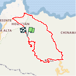
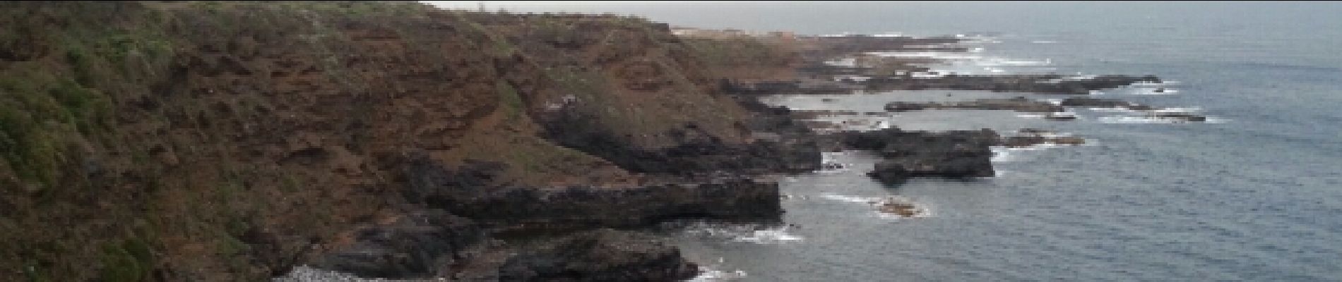
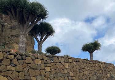
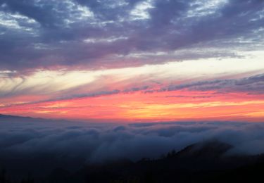
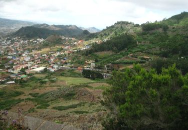
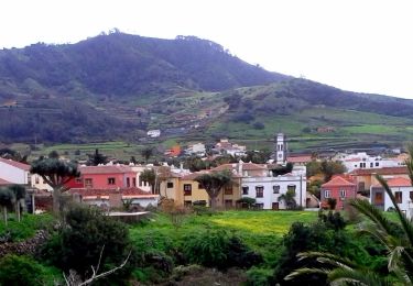
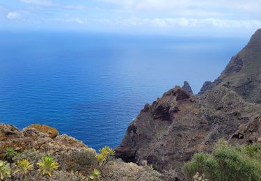
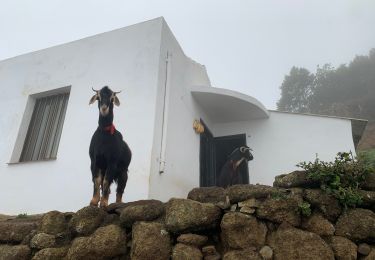
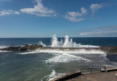
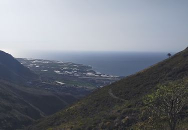
Randonnée Marche de 14,4 km à découvrir à Îles Canaries, Santa Cruz de Ténérife, San Cristóbal de La Laguna. Cette randonnée est proposée par karawatsj.
Description
Zeer gevarieerd zeer mooie tocht. Prachtige zichten.
Zaklamp meenemen voor tunnels.
POI3 en 4 verkeerd gelopen.
Localisation
Pays :
Espagne
Région :
Îles Canaries
Département/Province :
Santa Cruz de Ténérife
Commune :
San Cristóbal de La Laguna
Localité :
Unknown
Départ:(Dec)
Départ:(UTM)
371230 ; 3159921 (28R) N.
Commentaires
Randonnées à proximité
![Randonnée Marche San Cristóbal de La Laguna - Massif de l'Anaga El Batan Chinamada - Photo](https://media.geolcdn.com/t/375/260/bf287400-cf63-4351-bbc9-dbe9aba0fa64.jpg&format=jpg&maxdim=2)
![Marche Marche](https://static1.geolcdn.com/sitytour/trail-icons/101.png)
Massif de l'Anaga El Batan Chinamada
Marche
Très difficile
San Cristóbal de La Laguna,
Îles Canaries,
Santa Cruz de Ténérife,
Espagne
![](/images/other/stat-length.png)
10,8 km | 21 km-effort
4h 45min
![](https://static1.geolcdn.com/siteimages/upload/files/16400158638029165_repeat_loop_refresh_sync_direction_icon.png)
Oui
![Randonnée A pied Tegueste - El bosque de los enigmas - Photo](https://media.geolcdn.com/t/375/260/1a03fed7-fb28-4a0e-9d0f-13adda6bed3b.jpeg&format=jpg&maxdim=2)
![A pied A pied](https://static1.geolcdn.com/sitytour/trail-icons/100.png)
El bosque de los enigmas
A pied
Facile
(1)
Tegueste,
Îles Canaries,
Santa Cruz de Ténérife,
Espagne
![](/images/other/stat-length.png)
4,5 km | 6,7 km-effort
1h 31min
![](https://static1.geolcdn.com/siteimages/upload/files/16400158638029165_repeat_loop_refresh_sync_direction_icon.png)
Oui
![Randonnée A pied Tegueste - SL-TG 03 Las Canteras-Las Toscas - Photo](https://media.geolcdn.com/t/375/260/9b02a4e1-6549-4943-9eb8-9ef13f2363ff.jpeg&format=jpg&maxdim=2)
![A pied A pied](https://static1.geolcdn.com/sitytour/trail-icons/100.png)
SL-TG 03 Las Canteras-Las Toscas
A pied
Facile
Tegueste,
Îles Canaries,
Santa Cruz de Ténérife,
Espagne
![](/images/other/stat-length.png)
6,4 km | 9,8 km-effort
2h 13min
![](https://static1.geolcdn.com/siteimages/upload/files/16400158638029165_repeat_loop_refresh_sync_direction_icon.png)
Non
![Randonnée A pied San Cristóbal de La Laguna - ES-SL-TG 01 Tegueste-Bajamar - Photo](https://media.geolcdn.com/t/375/260/65f44273-f2cc-400e-98ab-6e6e24660cd8.jpeg&format=jpg&maxdim=2)
![A pied A pied](https://static1.geolcdn.com/sitytour/trail-icons/100.png)
ES-SL-TG 01 Tegueste-Bajamar
A pied
Facile
San Cristóbal de La Laguna,
Îles Canaries,
Santa Cruz de Ténérife,
Espagne
![](/images/other/stat-length.png)
8,9 km | 17,5 km-effort
3h 59min
![](https://static1.geolcdn.com/siteimages/upload/files/16400158638029165_repeat_loop_refresh_sync_direction_icon.png)
Non
![Randonnée Marche San Cristóbal de La Laguna - Punta del Hidalgo - Chinamada - Photo](https://media.geolcdn.com/t/375/260/2c9fb02f-c984-4854-86fb-fc5721d63a53.jpg&format=jpg&maxdim=2)
![Marche Marche](https://static1.geolcdn.com/sitytour/trail-icons/101.png)
Punta del Hidalgo - Chinamada
Marche
Moyen
San Cristóbal de La Laguna,
Îles Canaries,
Santa Cruz de Ténérife,
Espagne
![](/images/other/stat-length.png)
10,9 km | 20 km-effort
3h 30min
![](https://static1.geolcdn.com/siteimages/upload/files/16400158638029165_repeat_loop_refresh_sync_direction_icon.png)
Oui
![Randonnée Marche San Cristóbal de La Laguna - Las Carbonaras Chimada AR - Photo](https://media.geolcdn.com/t/375/260/b1c626c3-3510-4ce3-890e-282b82838da6.jpg&format=jpg&maxdim=2)
![Marche Marche](https://static1.geolcdn.com/sitytour/trail-icons/101.png)
Las Carbonaras Chimada AR
Marche
Facile
(1)
San Cristóbal de La Laguna,
Îles Canaries,
Santa Cruz de Ténérife,
Espagne
![](/images/other/stat-length.png)
5,7 km | 8,8 km-effort
1h 35min
![](https://static1.geolcdn.com/siteimages/upload/files/16400158638029165_repeat_loop_refresh_sync_direction_icon.png)
Oui
![Randonnée Marche San Cristóbal de La Laguna - Cruz del Carmen al Mar Bajamar - Photo](https://media.geolcdn.com/t/375/260/ext.jpg?maxdim=2&url=https%3A%2F%2Fservices.sitytrail.com%2FGeolivesWS%2FDownloadMedia.ashx%3FTrailID%3D908007%26Media%3Dfix__20180218155348.jpg)
![Marche Marche](https://static1.geolcdn.com/sitytour/trail-icons/101.png)
Cruz del Carmen al Mar Bajamar
Marche
Facile
San Cristóbal de La Laguna,
Îles Canaries,
Santa Cruz de Ténérife,
Espagne
![](/images/other/stat-length.png)
11,4 km | 15,6 km-effort
3h 4min
![](https://static1.geolcdn.com/siteimages/upload/files/16400158638029165_repeat_loop_refresh_sync_direction_icon.png)
Non
![Randonnée Marche San Cristóbal de La Laguna - forêt primaire de l'Anaga - Photo](https://media.geolcdn.com/t/375/260/ext.jpg?maxdim=2&url=https%3A%2F%2Fservices.sitytrail.com%2FGeolivesWS%2FDownloadMedia.ashx%3FTrailID%3D422872%26Media%3D20150511145711.jpg)
![Marche Marche](https://static1.geolcdn.com/sitytour/trail-icons/101.png)
forêt primaire de l'Anaga
Marche
Facile
(2)
San Cristóbal de La Laguna,
Îles Canaries,
Santa Cruz de Ténérife,
Espagne
![](/images/other/stat-length.png)
9,4 km | 13,4 km-effort
3h 23min
![](https://static1.geolcdn.com/siteimages/upload/files/16400158638029165_repeat_loop_refresh_sync_direction_icon.png)
Oui
![Randonnée Marche Tegueste - Cruz del Carmen - bajamar from half way - Photo](https://media.geolcdn.com/t/375/260/869fb28d-8541-4ec9-95a5-44120c6d68b4.jpg&format=jpg&maxdim=2)
![Marche Marche](https://static1.geolcdn.com/sitytour/trail-icons/101.png)
Cruz del Carmen - bajamar from half way
Marche
Difficile
Tegueste,
Îles Canaries,
Santa Cruz de Ténérife,
Espagne
![](/images/other/stat-length.png)
9,3 km | 12,8 km-effort
4h 44min
![](https://static1.geolcdn.com/siteimages/upload/files/16400158638029165_repeat_loop_refresh_sync_direction_icon.png)
Non