![](/images/other/stat-length.png)
![Randonnée Saint-Jean-le-Vieux - Bugey - St Jean le Vieux - Poncieux - Photo](https://media.geolcdn.com/t/1900/400/ext.pjpeg?maxdim=2&url=https%3A%2F%2Fsecurestorage.geolives.com%2Fsitytour%2Ftrail-bg%2Fdefault.jpg)
Bugey - St Jean le Vieux - Poncieux
micheljullien
Utilisateur
![Longueur](/images/other/stat-length.png)
Longueur
38 km
![Altitude max](https://static1.geolcdn.com/siteimages/upload/files/1508320355ic_sort_altitude_max_24dp.png)
Altitude max
631 m
![Dénivelé positif](https://static1.geolcdn.com/siteimages/upload/files/1508320355ic_sort_den_pos_24dp.png)
Dénivelé positif
1185 m
![Km-Effort](/images/other/stat-length.png)
Km-Effort
54 km
![Altitude min](https://static1.geolcdn.com/siteimages/upload/files/1508320355ic_sort_altitude_min_24dp.png)
Altitude min
241 m
![Dénivelé négatif](https://static1.geolcdn.com/siteimages/upload/files/1508320355ic_sort_den_neg_24dp.png)
Dénivelé négatif
1186 m
![Boucle](https://static1.geolcdn.com/siteimages/upload/files/16400158638029165_repeat_loop_refresh_sync_direction_icon.png)
Boucle
Oui
Date de création :
2023-10-17 10:10:34.262
Dernière modification :
2023-10-17 10:24:14.547
![Scannez ce code QR pour ouvrir la randonnée dans l'application SityTrail](https://capi.geolives.com/qq0zvz2zws4bq2lad0pu/sitytour/trails/3842636/qr.png?size=200)
Application GPS de randonnée GRATUITE
À propos
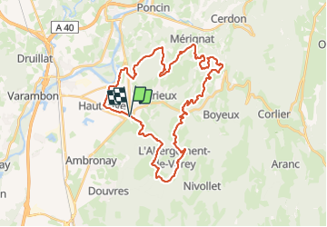
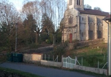
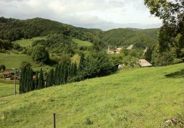
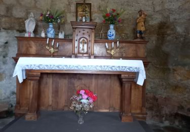
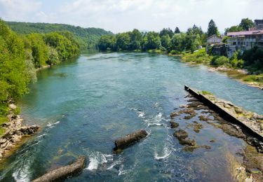
Randonnée de 38 km à découvrir à Auvergne-Rhône-Alpes, Ain, Saint-Jean-le-Vieux. Cette randonnée est proposée par micheljullien.
Description
Sortie VTT autour de Jujurieux au départ de St Jean le Vieux en passant par le bois de Charmontay, Breignes, la combe longe, la combe Chabot, Poncieux, Cossieux, l\'Abergement de Varey et le bois de Fayat
Localisation
Pays :
France
Région :
Auvergne-Rhône-Alpes
Département/Province :
Ain
Commune :
Saint-Jean-le-Vieux
Localité :
Unknown
Départ:(Dec)
Départ:(UTM)
684983 ; 5099998 (31T) N.
Commentaires
Randonnées à proximité
![Randonnée V.T.T. Saint-Jean-le-Vieux - rando balcon de l'ain 40km - Photo](https://media.geolcdn.com/t/375/260/ext.jpg?maxdim=2&url=https%3A%2F%2Fstatic1.geolcdn.com%2Fsiteimages%2Fupload%2Ffiles%2F1524743154velo.jpg)
![V.T.T. V.T.T.](https://static1.geolcdn.com/sitytour/trail-icons/202.png)
rando balcon de l'ain 40km
V.T.T.
Très facile
(2)
Saint-Jean-le-Vieux,
Auvergne-Rhône-Alpes,
Ain,
France
![](/images/other/stat-length.png)
38 km | 51 km-effort
3h 50min
![](https://static1.geolcdn.com/siteimages/upload/files/16400158638029165_repeat_loop_refresh_sync_direction_icon.png)
Oui
![Randonnée Marche Pont-d'Ain - pont d'ain château d'hterive - Photo](https://media.geolcdn.com/t/375/260/c689ffda-8228-4bed-a167-c62bd6361f49.jpg&format=jpg&maxdim=2)
![Marche Marche](https://static1.geolcdn.com/sitytour/trail-icons/101.png)
pont d'ain château d'hterive
Marche
Difficile
Pont-d'Ain,
Auvergne-Rhône-Alpes,
Ain,
France
![](/images/other/stat-length.png)
15,1 km | 16,1 km-effort
3h 54min
![](https://static1.geolcdn.com/siteimages/upload/files/16400158638029165_repeat_loop_refresh_sync_direction_icon.png)
Oui
![Randonnée Marche Jujurieux - 01-Jujurieux-Neuville-restau-18-7km-440m-fev22 - Photo](https://media.geolcdn.com/t/375/260/51235138-d6dc-494f-9a52-96125c4e0560.jpg&format=jpg&maxdim=2)
![Marche Marche](https://static1.geolcdn.com/sitytour/trail-icons/101.png)
01-Jujurieux-Neuville-restau-18-7km-440m-fev22
Marche
Moyen
Jujurieux,
Auvergne-Rhône-Alpes,
Ain,
France
![](/images/other/stat-length.png)
18,6 km | 25 km-effort
4h 54min
![](https://static1.geolcdn.com/siteimages/upload/files/16400158638029165_repeat_loop_refresh_sync_direction_icon.png)
Oui
![Randonnée Marche Saint-Jean-le-Vieux - forêt de Saint Jean - Photo](https://media.geolcdn.com/t/375/260/247fc458-18ce-4629-a62d-791cbc4f79cf.jpg&format=jpg&maxdim=2)
![Marche Marche](https://static1.geolcdn.com/sitytour/trail-icons/101.png)
forêt de Saint Jean
Marche
Très facile
Saint-Jean-le-Vieux,
Auvergne-Rhône-Alpes,
Ain,
France
![](/images/other/stat-length.png)
5,8 km | 9 km-effort
1h 41min
![](https://static1.geolcdn.com/siteimages/upload/files/16400158638029165_repeat_loop_refresh_sync_direction_icon.png)
Non
![Randonnée Marche Douvres - douvres - Photo](https://media.geolcdn.com/t/375/260/ext.jpg?maxdim=2&url=https%3A%2F%2Fservices.sitytrail.com%2FGeolivesWS%2FDownloadMedia.ashx%3FTrailID%3D234611%26Media%3Dfix__20131125153424.jpg)
![Marche Marche](https://static1.geolcdn.com/sitytour/trail-icons/101.png)
douvres
Marche
Facile
Douvres,
Auvergne-Rhône-Alpes,
Ain,
France
![](/images/other/stat-length.png)
11,7 km | 16,4 km-effort
2h 31min
![](https://static1.geolcdn.com/siteimages/upload/files/16400158638029165_repeat_loop_refresh_sync_direction_icon.png)
Oui
![Randonnée Marche Douvres - chateau de allymes - Photo](https://media.geolcdn.com/t/375/260/ext.jpg?maxdim=2&url=https%3A%2F%2Fstatic1.geolcdn.com%2Fsiteimages%2Fupload%2Ffiles%2F1553511878bg_sport_marche.png)
![Marche Marche](https://static1.geolcdn.com/sitytour/trail-icons/101.png)
chateau de allymes
Marche
Très facile
(2)
Douvres,
Auvergne-Rhône-Alpes,
Ain,
France
![](/images/other/stat-length.png)
8,6 km | 13,9 km-effort
2h 0min
![](https://static1.geolcdn.com/siteimages/upload/files/16400158638029165_repeat_loop_refresh_sync_direction_icon.png)
Oui
![Randonnée V.T.T. Douvres - Douvres 65km 2780m - Photo](https://media.geolcdn.com/t/375/260/ext.jpg?maxdim=2&url=https%3A%2F%2Fservices.sitytrail.com%2FGeolivesWS%2FDownloadMedia.ashx%3FTrailID%3D107136%26Media%3D11972_3.jpg)
![V.T.T. V.T.T.](https://static1.geolcdn.com/sitytour/trail-icons/202.png)
Douvres 65km 2780m
V.T.T.
Très difficile
Douvres,
Auvergne-Rhône-Alpes,
Ain,
France
![](/images/other/stat-length.png)
64 km | 97 km-effort
7h 0min
![](https://static1.geolcdn.com/siteimages/upload/files/16400158638029165_repeat_loop_refresh_sync_direction_icon.png)
Oui
![Randonnée Marche Jujurieux - les châteaux de jujurieux - Photo](https://media.geolcdn.com/t/375/260/9583454c-9322-4e50-aa44-6fe2cafeea4d.jpg&format=jpg&maxdim=2)
![Marche Marche](https://static1.geolcdn.com/sitytour/trail-icons/101.png)
les châteaux de jujurieux
Marche
Facile
Jujurieux,
Auvergne-Rhône-Alpes,
Ain,
France
![](/images/other/stat-length.png)
14 km | 18,4 km-effort
4h 29min
![](https://static1.geolcdn.com/siteimages/upload/files/16400158638029165_repeat_loop_refresh_sync_direction_icon.png)
Oui
![Randonnée Marche Jujurieux - Rando bugiste - Chenavel - Photo](https://media.geolcdn.com/t/375/260/ext.jpg?maxdim=2&url=https%3A%2F%2Fservices.sitytrail.com%2FGeolivesWS%2FDownloadMedia.ashx%3FTrailID%3D215085%26Media%3D15659_2.jpg)
![Marche Marche](https://static1.geolcdn.com/sitytour/trail-icons/101.png)
Rando bugiste - Chenavel
Marche
Difficile
Jujurieux,
Auvergne-Rhône-Alpes,
Ain,
France
![](/images/other/stat-length.png)
23 km | 31 km-effort
5h 0min
![](https://static1.geolcdn.com/siteimages/upload/files/16400158638029165_repeat_loop_refresh_sync_direction_icon.png)
Oui