Randonnée  Saint-Sébastien - 16/10/23 - Photo
© OpenStreetMap contributors
Longueur
Longueur
7,3 km
Altitude max
Altitude max
338 m
Dénivelé positif
Dénivelé positif
169 m
Km-Effort
Km-Effort  
9,6 km
Altitude min
Altitude min
255 m
Dénivelé négatif
Dénivelé négatif
162 m
Boucle
Boucle
Oui
Date de création :
2023-10-16 13:42:43.0
Dernière modification :
2023-10-16 15:04:41.778

(0 Avis)


Scannez ce code QR pour ouvrir la randonnée dans l'application SityTrail

Application GPS de randonnée GRATUITE

Logo SityTrail SityTrail

IGN / Instituts géographiques

Télécharger SityTrail sur l'App Store Télécharger SityTrail sur Google Play

Logo SityTrail SityTrail World

Le monde est à vous

Télécharger SityTrail sur l'App Store Télécharger SityTrail sur Google Play Télécharger SityTrail sur Huawei AppGallery

À propos

Randonnée de 7,3 km à découvrir à Nouvelle-Aquitaine, Creuse, Saint-Sébastien. Cette randonnée est proposée par 000646.2bff3478caf44375872b56d8d6397886.1503.

Profil altimétrique

Localisation

Pays :
France
Région :
Nouvelle-Aquitaine
Département/Province :
Creuse
Commune :
Saint-Sébastien
Localité :
Unknown
Départ:(Dec)
Départ:(UTM)
388528 ; 5138672 (31T) N.

Randonnées à proximité

Randonnée Randonnée équestre Saint-Sébastien - ancienne voie ferrée  - Photo
Randonnée équestre
xpeps

Randonnée équestre

Moyen
Saint-Sébastien, Nouvelle-Aquitaine, Creuse, France
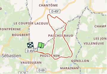
18,4 km | 22 km-effort
44min
Non
Randonnée Marche Saint-Plantaire - Le rocher de la Fileuse - Photo
Marche
Phil36

Marche

Difficile
Saint-Plantaire, Centre-Val de Loire, Indre, France
13,1 km | 16,7 km-effort
3h 48min
Oui
Randonnée Marche Saint-Plantaire - 2ème Randonnée Crozant - Photo
Marche
GUIDE
jeanmarcMasson

Marche

Très difficile
Saint-Plantaire, Centre-Val de Loire, Indre, France
16,7 km | 22 km-effort
4h 40min
Oui
Randonnée Marche Crozant - Compostelle etape 14 - Photo
Marche
maginot

Marche

Moyen
Crozant, Nouvelle-Aquitaine, Creuse, France
23 km | 27 km-effort
5h 27min
Non
Randonnée Randonnée équestre Lafat - Fresselines 23-05-21 - Photo
Randonnée équestre
Gus23

Randonnée équestre

Moyen
Lafat, Nouvelle-Aquitaine, Creuse, France
25 km | 30 km-effort
3h 57min
Oui
Randonnée Marche Saint-Plantaire - Fougère plage - Crozant - Photo
Marche
pgeiger

Marche

Facile
Saint-Plantaire, Centre-Val de Loire, Indre, France
14,8 km | 20 km-effort
6h 57min
Non
Randonnée V.T.T. Éguzon-Chantôme - Eguzon 2019 - Photo
V.T.T.
pates_au_chaud

V.T.T.

Difficile
Éguzon-Chantôme, Centre-Val de Loire, Indre, France
42 km | 53 km-effort
4h 31min
Oui
Randonnée Marche Éguzon-Chantôme - eguzon crozant - Photo
Marche
jces

Marche

Moyen
Éguzon-Chantôme, Centre-Val de Loire, Indre, France
14,7 km | 19,5 km-effort
4h 3min
Oui
Randonnée V.T.T. Éguzon-Chantôme - Eguzon 2017 - Photo
V.T.T.
pates_au_chaud

V.T.T.

Difficile
Éguzon-Chantôme, Centre-Val de Loire, Indre, France
30 km | 39 km-effort
4h 0min
Oui


Fermer
Mes abonnements