![](/images/other/stat-length.png)
![Randonnée Marche Saint-Louis - Makes Piton Cabris - La Fenetre - Les Fleurs Jaunes - Photo](https://media.geolcdn.com/t/1900/400/ext.pjpeg?maxdim=2&url=https%3A%2F%2Fservices.sitytrail.com%2FGeolivesWS%2FDownloadMedia.ashx%3FTrailID%3D384162%26Media%3Dd1195190-bfc3-4a9d-bb51-fa58f53afe6a.jpg)
Makes Piton Cabris - La Fenetre - Les Fleurs Jaunes
Med974
Utilisateur
![Longueur](/images/other/stat-length.png)
![Altitude max](https://static1.geolcdn.com/siteimages/upload/files/1508320355ic_sort_altitude_max_24dp.png)
![Dénivelé positif](https://static1.geolcdn.com/siteimages/upload/files/1508320355ic_sort_den_pos_24dp.png)
![Km-Effort](/images/other/stat-length.png)
![Altitude min](https://static1.geolcdn.com/siteimages/upload/files/1508320355ic_sort_altitude_min_24dp.png)
![Dénivelé négatif](https://static1.geolcdn.com/siteimages/upload/files/1508320355ic_sort_den_neg_24dp.png)
![Boucle](https://static1.geolcdn.com/siteimages/upload/files/16400158638029165_repeat_loop_refresh_sync_direction_icon.png)
![Marche](https://static1.geolcdn.com/sitytour/trail-icons/101.png)
1h35
Difficulté : Facile
![Scannez ce code QR pour ouvrir la randonnée dans l'application SityTrail](https://capi.geolives.com/qq0zvz2zws4bq2lad0pu/sitytour/trails/384162/qr.png?size=200)
Application GPS de randonnée GRATUITE
À propos
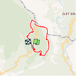
Randonnée Marche de 8,4 km à découvrir à La Réunion, Inconnu, Saint-Louis. Cette randonnée est proposée par Med974.
Description
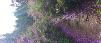
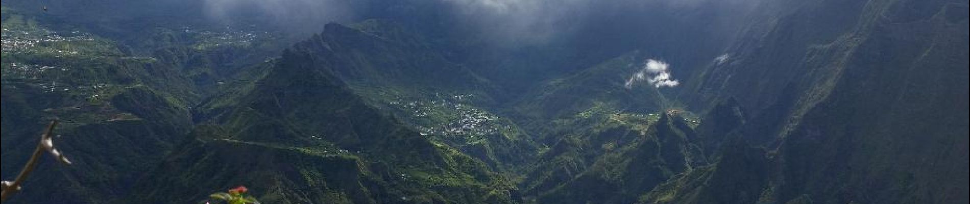
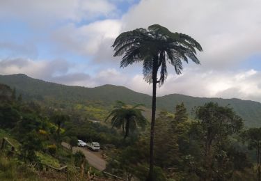
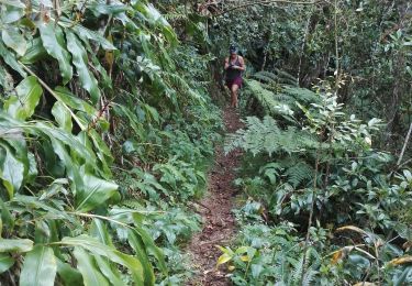
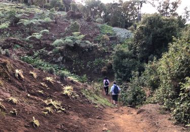
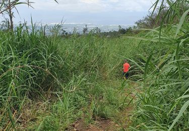
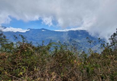
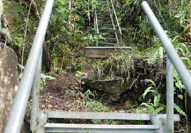
Se rendre aux Makes et s'arreter sur la route principale au niveau d'une aire de pique nique. Un panneau indique le début du sentier. Prendre à droite à la 1ère bifurcation puis à gauche à le 2ème où l'on peut observer de magnifiques fleurs jaunes et violettes (voir photo). On continu ensuite dans une grande forêt de cryptomerias où les racines apparentes peuvent créer des difficultés par temps humide. Les arbres sont si rapprochés qu'on a parfois l'impression que la nuit va tomber. On retrouve la lumière en pleine ascension du Piton Cabris et les cryptomerias sont remplacés par des bois de couleurs. Les panoramas sur Cilaos durant la descente sont extraordinaires. On a devant les yeux 180 degrés du cirque et on distingue à la fois le Grand Bénare, le Dimitile, et tous les îlets du Cirque et Cilaos. La remontée à la Fenêtre est courte mais pentue. On peut y faire une seconde halte afin d'admirer une dernière fois ce magnifique cirque. Avant d'entamer la montée vers le Petit Mapou, bien regarder à droite de la piste si aucun pancarte ne vient indiquer d'abattage de bois plus haut. Si c'est le cas, entreprendre le début de la Montée vers le Grand Bénare et bifurquer à gauche au premier croisement sur une belle piste herbeuse bordée d'arums. Plus loin, la descente à travers les pentes de Fleurs Jaunes permet d'admirer la belle région des Makes. Le reste de la randonnée s'effectuera sur la route forestière,
rando faite le 08/02/2015. Temps indiqué réalisé en courant sur les parties plates et descentes, voir ici :
http://www.mygeonaute.com/fr-FR/portal/activities/7b0ec469291f293edb8f
Localisation
Commentaires
Randonnées à proximité
![Randonnée Marche Saint-Louis - Fenêtre des Makes par Piton Cabri - Photo](https://media.geolcdn.com/t/375/260/404e6fa7-cedf-4f71-b3b5-38d1f3b143ad.jpg&format=jpg&maxdim=2)
![Marche Marche](https://static1.geolcdn.com/sitytour/trail-icons/101.png)
Marche
![](/images/other/stat-length.png)
![](https://static1.geolcdn.com/siteimages/upload/files/16400158638029165_repeat_loop_refresh_sync_direction_icon.png)
![Randonnée Marche Saint-Louis - Sentier découverte des Makes - Photo](https://media.geolcdn.com/t/375/260/e0a2a7b6-7fb4-493b-b407-5bd5656a61ed.jpg&format=jpg&maxdim=2)
![Marche Marche](https://static1.geolcdn.com/sitytour/trail-icons/101.png)
Marche
![](/images/other/stat-length.png)
![](https://static1.geolcdn.com/siteimages/upload/files/16400158638029165_repeat_loop_refresh_sync_direction_icon.png)
![Randonnée Marche Saint-Louis - Bras patate - Photo](https://media.geolcdn.com/t/375/260/5564c97b-f465-463b-8d9f-6c4fbffbf8f2.jpg&format=jpg&maxdim=2)
![Marche Marche](https://static1.geolcdn.com/sitytour/trail-icons/101.png)
Marche
![](/images/other/stat-length.png)
![](https://static1.geolcdn.com/siteimages/upload/files/16400158638029165_repeat_loop_refresh_sync_direction_icon.png)
![Randonnée Marche Saint-Louis - Piton Cabri par Bras Patate 1 7 15 - Photo](https://media.geolcdn.com/t/375/260/ext.jpg?maxdim=2&url=https%3A%2F%2Fservices.sitytrail.com%2FGeolivesWS%2FDownloadMedia.ashx%3FTrailID%3D452671%26Media%3Dfix__20150701122445.jpg)
![Marche Marche](https://static1.geolcdn.com/sitytour/trail-icons/101.png)
Marche
![](/images/other/stat-length.png)
![](https://static1.geolcdn.com/siteimages/upload/files/16400158638029165_repeat_loop_refresh_sync_direction_icon.png)
![Randonnée Marche Saint-Louis - La Réunion - Boucle de la fenêtre des Makes par Piton Cabris - Photo](https://media.geolcdn.com/t/375/260/ext.jpg?maxdim=2&url=https%3A%2F%2Fservices.sitytrail.com%2FGeolivesWS%2FDownloadMedia.ashx%3FTrailID%3D412392%26Media%3Dfix__20150426102959.jpg)
![Marche Marche](https://static1.geolcdn.com/sitytour/trail-icons/101.png)
Marche
![](/images/other/stat-length.png)
![](https://static1.geolcdn.com/siteimages/upload/files/16400158638029165_repeat_loop_refresh_sync_direction_icon.png)
![Randonnée Marche Entre-Deux - Bayonne retour zèbre - Photo](https://media.geolcdn.com/t/375/260/ext.jpg?maxdim=2&url=https%3A%2F%2Fstatic1.geolcdn.com%2Fsiteimages%2Fupload%2Ffiles%2F1553511878bg_sport_marche.png)
![Marche Marche](https://static1.geolcdn.com/sitytour/trail-icons/101.png)
Marche
![](/images/other/stat-length.png)
![](https://static1.geolcdn.com/siteimages/upload/files/16400158638029165_repeat_loop_refresh_sync_direction_icon.png)
![Randonnée Marche Saint-Louis - Le tapage piton cabris retour via bras patate - Photo](https://media.geolcdn.com/t/375/260/574db9b9-9445-46e4-9a90-a7e5b9794905.jpg&format=jpg&maxdim=2)
![Marche Marche](https://static1.geolcdn.com/sitytour/trail-icons/101.png)
Marche
![](/images/other/stat-length.png)
![](https://static1.geolcdn.com/siteimages/upload/files/16400158638029165_repeat_loop_refresh_sync_direction_icon.png)
![Randonnée Marche Saint-Louis - Tapage - Piton Cabris - La Fenêtre - Photo](https://media.geolcdn.com/t/375/260/0bdbdfd0-cac8-4aef-a896-450f0babbccc.jpg&format=jpg&maxdim=2)
![Marche Marche](https://static1.geolcdn.com/sitytour/trail-icons/101.png)
Marche
![](/images/other/stat-length.png)
![](https://static1.geolcdn.com/siteimages/upload/files/16400158638029165_repeat_loop_refresh_sync_direction_icon.png)
![Randonnée Marche Saint-Louis - Makes/Petit Mapou par 11e ligne - Photo](https://media.geolcdn.com/t/375/260/ec2689fe-b6ab-4eb5-a4db-eec5e368e542.jpg&format=jpg&maxdim=2)
![Marche Marche](https://static1.geolcdn.com/sitytour/trail-icons/101.png)
Marche
![](/images/other/stat-length.png)
![](https://static1.geolcdn.com/siteimages/upload/files/16400158638029165_repeat_loop_refresh_sync_direction_icon.png)
11/2015. Première rando à la Reunion. Superbe pour les points de vue et le type de sentiers