![](/images/other/stat-length.png)
![Randonnée Marche La Farlède - De la farléde vers l'ozone à La Valette - Photo](https://media.geolcdn.com/t/1900/400/7ea6ca5f-1580-432e-879d-786d58e9b422.jpg&format=pjpeg&maxdim=2)
De la farléde vers l'ozone à La Valette
FSantoni
Utilisateur
![Longueur](/images/other/stat-length.png)
Longueur
12,4 km
![Altitude max](https://static1.geolcdn.com/siteimages/upload/files/1508320355ic_sort_altitude_max_24dp.png)
Altitude max
295 m
![Dénivelé positif](https://static1.geolcdn.com/siteimages/upload/files/1508320355ic_sort_den_pos_24dp.png)
Dénivelé positif
377 m
![Km-Effort](/images/other/stat-length.png)
Km-Effort
17,4 km
![Altitude min](https://static1.geolcdn.com/siteimages/upload/files/1508320355ic_sort_altitude_min_24dp.png)
Altitude min
90 m
![Dénivelé négatif](https://static1.geolcdn.com/siteimages/upload/files/1508320355ic_sort_den_neg_24dp.png)
Dénivelé négatif
376 m
![Boucle](https://static1.geolcdn.com/siteimages/upload/files/16400158638029165_repeat_loop_refresh_sync_direction_icon.png)
Boucle
Oui
Date de création :
2023-10-14 06:36:02.015
Dernière modification :
2023-10-14 14:39:58.71
![Marche](https://static1.geolcdn.com/sitytour/trail-icons/101.png)
5h31
Difficulté : Difficile
![Scannez ce code QR pour ouvrir la randonnée dans l'application SityTrail](https://capi.geolives.com/qq0zvz2zws4bq2lad0pu/sitytour/trails/3839589/qr.png?size=200)
Application GPS de randonnée GRATUITE
À propos
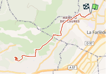
Randonnée Marche de 12,4 km à découvrir à Provence-Alpes-Côte d'Azur, Var, La Farlède. Cette randonnée est proposée par FSantoni.
Description
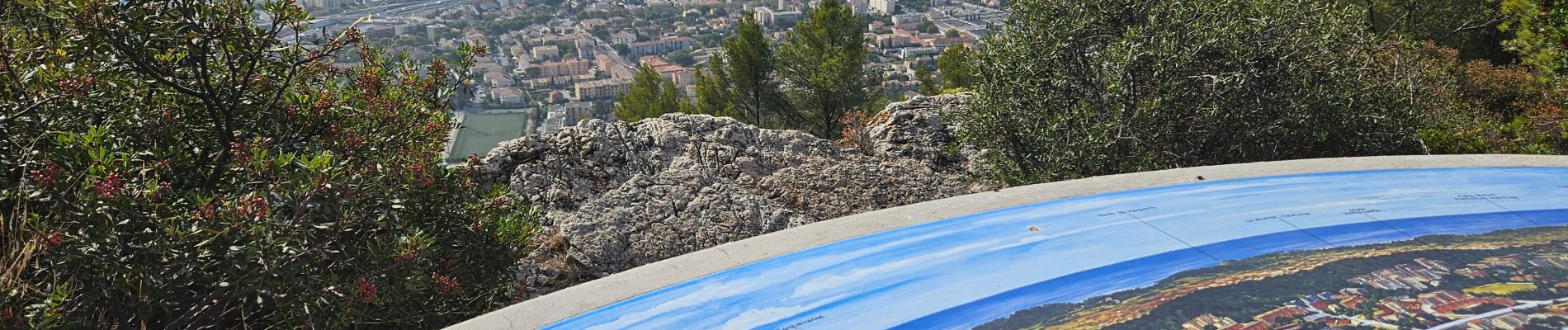
Peu de temps dispo ce samedi, juste assez pour cette rando trés moyenne, et avec peu d'interet si ce n'est la table d'orientation qui surplombe toute la rade de Toulon.
Localisation
Pays :
France
Région :
Provence-Alpes-Côte d'Azur
Département/Province :
Var
Commune :
La Farlède
Localité :
Unknown
Départ:(Dec)
Départ:(UTM)
259376 ; 4783698 (32T) N.
Commentaires
Randonnées à proximité
![Randonnée Marche Solliès-Toucas - Valaury - Apier - Matheron - Photo](https://media.geolcdn.com/t/375/260/f02c0563-7d49-437f-98bb-e34f8a550dee.jpg&format=jpg&maxdim=2)
![Marche Marche](https://static1.geolcdn.com/sitytour/trail-icons/101.png)
Valaury - Apier - Matheron
Marche
Moyen
(1)
Solliès-Toucas,
Provence-Alpes-Côte d'Azur,
Var,
France
![](/images/other/stat-length.png)
13,1 km | 19,5 km-effort
5h 0min
![](https://static1.geolcdn.com/siteimages/upload/files/16400158638029165_repeat_loop_refresh_sync_direction_icon.png)
Oui
![Randonnée Marche La Valette-du-Var - Le tour du Coudon - Confinement 04 2021 - Photo](https://media.geolcdn.com/t/375/260/c1a593ce-5178-4a51-a2b4-9401a3556db4.jpg&format=jpg&maxdim=2)
![Marche Marche](https://static1.geolcdn.com/sitytour/trail-icons/101.png)
Le tour du Coudon - Confinement 04 2021
Marche
Difficile
(1)
La Valette-du-Var,
Provence-Alpes-Côte d'Azur,
Var,
France
![](/images/other/stat-length.png)
11,9 km | 19,4 km-effort
5h 0min
![](https://static1.geolcdn.com/siteimages/upload/files/16400158638029165_repeat_loop_refresh_sync_direction_icon.png)
Oui
![Randonnée Marche La Crau - fenouillet Daniel Louis - Photo](https://media.geolcdn.com/t/375/260/74a8e577-0c5f-4f83-9925-bb595eab64a1.jpg&format=jpg&maxdim=2)
![Marche Marche](https://static1.geolcdn.com/sitytour/trail-icons/101.png)
fenouillet Daniel Louis
Marche
Moyen
(1)
La Crau,
Provence-Alpes-Côte d'Azur,
Var,
France
![](/images/other/stat-length.png)
18,1 km | 25 km-effort
4h 36min
![](https://static1.geolcdn.com/siteimages/upload/files/16400158638029165_repeat_loop_refresh_sync_direction_icon.png)
Oui
![Randonnée Marche La Crau - le fenouillet un après-midi d'automne - Photo](https://media.geolcdn.com/t/375/260/ext.jpg?maxdim=2&url=https%3A%2F%2Fservices.sitytrail.com%2FGeolivesWS%2FDownloadMedia.ashx%3FTrailID%3D650501%26Media%3D20161024161101.jpg)
![Marche Marche](https://static1.geolcdn.com/sitytour/trail-icons/101.png)
le fenouillet un après-midi d'automne
Marche
Facile
(2)
La Crau,
Provence-Alpes-Côte d'Azur,
Var,
France
![](/images/other/stat-length.png)
7,6 km | 10,7 km-effort
1h 48min
![](https://static1.geolcdn.com/siteimages/upload/files/16400158638029165_repeat_loop_refresh_sync_direction_icon.png)
Oui
![Randonnée Marche Solliès-Toucas - couvent St Hubert Valaury - Photo](https://media.geolcdn.com/t/375/260/ext.jpg?maxdim=2&url=https%3A%2F%2Fservices.sitytrail.com%2FGeolivesWS%2FDownloadMedia.ashx%3FTrailID%3D361125%26Media%3Dfix__20141108152604.jpg)
![Marche Marche](https://static1.geolcdn.com/sitytour/trail-icons/101.png)
couvent St Hubert Valaury
Marche
Très facile
(2)
Solliès-Toucas,
Provence-Alpes-Côte d'Azur,
Var,
France
![](/images/other/stat-length.png)
12,5 km | 19,2 km-effort
4h 30min
![](https://static1.geolcdn.com/siteimages/upload/files/16400158638029165_repeat_loop_refresh_sync_direction_icon.png)
Oui
![Randonnée Trail Solliès-Pont - Mont Goudon boucle - Photo](https://media.geolcdn.com/t/375/260/c2cc87c3-0b5e-469f-91a1-61249a1514ac.jpg&format=jpg&maxdim=2)
![Trail Trail](https://static1.geolcdn.com/sitytour/trail-icons/104.png)
Mont Goudon boucle
Trail
Difficile
Solliès-Pont,
Provence-Alpes-Côte d'Azur,
Var,
France
![](/images/other/stat-length.png)
28 km | 43 km-effort
4h 35min
![](https://static1.geolcdn.com/siteimages/upload/files/16400158638029165_repeat_loop_refresh_sync_direction_icon.png)
Oui
![Randonnée Trail Solliès-Pont - Le Coudon - Photo](https://media.geolcdn.com/t/375/260/abb8f2fd-c3f3-40be-97f6-8c7a30b446a6.jpg&format=jpg&maxdim=2)
![Trail Trail](https://static1.geolcdn.com/sitytour/trail-icons/104.png)
Le Coudon
Trail
Difficile
Solliès-Pont,
Provence-Alpes-Côte d'Azur,
Var,
France
![](/images/other/stat-length.png)
22 km | 35 km-effort
3h 30min
![](https://static1.geolcdn.com/siteimages/upload/files/16400158638029165_repeat_loop_refresh_sync_direction_icon.png)
Oui
![Randonnée Trail La Crau - Le Fenouillet et château d' Hyères - Photo](https://media.geolcdn.com/t/375/260/b5c97bc5-16a4-4fca-8ec6-5ff57c47ff40.jpg&format=jpg&maxdim=2)
![Trail Trail](https://static1.geolcdn.com/sitytour/trail-icons/104.png)
Le Fenouillet et château d' Hyères
Trail
Moyen
La Crau,
Provence-Alpes-Côte d'Azur,
Var,
France
![](/images/other/stat-length.png)
13,1 km | 18,8 km-effort
2h 9min
![](https://static1.geolcdn.com/siteimages/upload/files/16400158638029165_repeat_loop_refresh_sync_direction_icon.png)
Non
![Randonnée Marche La Crau - Fenouillet - Chateau de Hyères - retour par les vignes - Photo](https://media.geolcdn.com/t/375/260/d2132167-a625-4ff2-ae44-a142bdaeb4e4.jpg&format=jpg&maxdim=2)
![Marche Marche](https://static1.geolcdn.com/sitytour/trail-icons/101.png)
Fenouillet - Chateau de Hyères - retour par les vignes
Marche
Moyen
(2)
La Crau,
Provence-Alpes-Côte d'Azur,
Var,
France
![](/images/other/stat-length.png)
14,1 km | 19,7 km-effort
5h 0min
![](https://static1.geolcdn.com/siteimages/upload/files/16400158638029165_repeat_loop_refresh_sync_direction_icon.png)
Oui