![](/images/other/stat-length.png)
![Randonnée Marche Saint-Vallier - Saint Vallier via les Baudins et l'étang de la Garenne - Photo](https://media.geolcdn.com/t/1900/400/ext.pjpeg?maxdim=2&url=https%3A%2F%2Fstatic1.geolcdn.com%2Fsiteimages%2Fupload%2Ffiles%2F1553511878bg_sport_marche.png)
Saint Vallier via les Baudins et l'étang de la Garenne
PASSION RANDO
Marcher en groupe en veillant au respect de chacun et à la bonne humeur.
![Longueur](/images/other/stat-length.png)
Longueur
7,9 km
![Altitude max](https://static1.geolcdn.com/siteimages/upload/files/1508320355ic_sort_altitude_max_24dp.png)
Altitude max
338 m
![Dénivelé positif](https://static1.geolcdn.com/siteimages/upload/files/1508320355ic_sort_den_pos_24dp.png)
Dénivelé positif
139 m
![Km-Effort](/images/other/stat-length.png)
Km-Effort
9,8 km
![Altitude min](https://static1.geolcdn.com/siteimages/upload/files/1508320355ic_sort_altitude_min_24dp.png)
Altitude min
281 m
![Dénivelé négatif](https://static1.geolcdn.com/siteimages/upload/files/1508320355ic_sort_den_neg_24dp.png)
Dénivelé négatif
139 m
![Boucle](https://static1.geolcdn.com/siteimages/upload/files/16400158638029165_repeat_loop_refresh_sync_direction_icon.png)
Boucle
Oui
Date de création :
2023-10-12 16:23:18.237
Dernière modification :
2024-01-17 15:35:28.065
![Marche](https://static1.geolcdn.com/sitytour/trail-icons/101.png)
2h13
Difficulté : Moyen
![Scannez ce code QR pour ouvrir la randonnée dans l'application SityTrail](https://capi.geolives.com/qq0zvz2zws4bq2lad0pu/sitytour/trails/3838080/qr.png?size=200)
Application GPS de randonnée GRATUITE
À propos
Randonnée Marche de 7,9 km à découvrir à Bourgogne-Franche-Comté, Saône-et-Loire, Saint-Vallier. Cette randonnée est proposée par PASSION RANDO.
Description
effectuée le 12 octobre 2023
Localisation
Pays :
France
Région :
Bourgogne-Franche-Comté
Département/Province :
Saône-et-Loire
Commune :
Saint-Vallier
Localité :
Unknown
Départ:(Dec)
Départ:(UTM)
604993 ; 5166315 (31T) N.
Commentaires
Randonnées à proximité
![Randonnée Marche Pouilloux - POUILLOUX LA PRERE - Photo](https://media.geolcdn.com/t/375/260/ext.jpg?maxdim=2&url=https%3A%2F%2Fstatic1.geolcdn.com%2Fsiteimages%2Fupload%2Ffiles%2F1553511878bg_sport_marche.png)
![Marche Marche](https://static1.geolcdn.com/sitytour/trail-icons/101.png)
POUILLOUX LA PRERE
Marche
Moyen
(1)
Pouilloux,
Bourgogne-Franche-Comté,
Saône-et-Loire,
France
![](/images/other/stat-length.png)
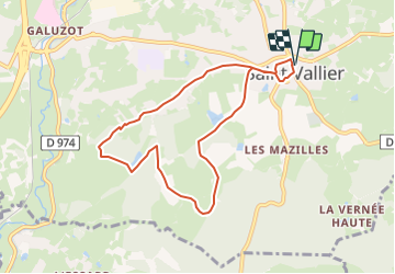
9,7 km | 10,9 km-effort
2h 28min
![](https://static1.geolcdn.com/siteimages/upload/files/16400158638029165_repeat_loop_refresh_sync_direction_icon.png)
Oui
![Randonnée Marche Sanvignes-les-Mines - sanvignes - Photo](https://media.geolcdn.com/t/375/260/ext.jpg?maxdim=2&url=https%3A%2F%2Fservices.sitytrail.com%2FGeolivesWS%2FDownloadMedia.ashx%3FTrailID%3D391981%26Media%3Dfix__20150303152322.jpg)
![Marche Marche](https://static1.geolcdn.com/sitytour/trail-icons/101.png)
sanvignes
Marche
Très facile
Sanvignes-les-Mines,
Bourgogne-Franche-Comté,
Saône-et-Loire,
France
![](/images/other/stat-length.png)
7,7 km | 9 km-effort
1h 48min
![](https://static1.geolcdn.com/siteimages/upload/files/16400158638029165_repeat_loop_refresh_sync_direction_icon.png)
Oui
![Randonnée Marche Saint-Romain-sous-Gourdon - RANDO SAINT ROMAIN/GOURDON GRS 12KM - Photo](https://media.geolcdn.com/t/375/260/ext.jpg?maxdim=2&url=https%3A%2F%2Fstatic1.geolcdn.com%2Fsiteimages%2Fupload%2Ffiles%2F1553511878bg_sport_marche.png)
![Marche Marche](https://static1.geolcdn.com/sitytour/trail-icons/101.png)
RANDO SAINT ROMAIN/GOURDON GRS 12KM
Marche
Moyen
Saint-Romain-sous-Gourdon,
Bourgogne-Franche-Comté,
Saône-et-Loire,
France
![](/images/other/stat-length.png)
11,8 km | 15,3 km-effort
2h 16min
![](https://static1.geolcdn.com/siteimages/upload/files/16400158638029165_repeat_loop_refresh_sync_direction_icon.png)
Oui
![Randonnée Marche Montceau-les-Mines - Montceau Piscine - Photo](https://media.geolcdn.com/t/375/260/ext.jpg?maxdim=2&url=https%3A%2F%2Fstatic1.geolcdn.com%2Fsiteimages%2Fupload%2Ffiles%2F1553511878bg_sport_marche.png)
![Marche Marche](https://static1.geolcdn.com/sitytour/trail-icons/101.png)
Montceau Piscine
Marche
Difficile
Montceau-les-Mines,
Bourgogne-Franche-Comté,
Saône-et-Loire,
France
![](/images/other/stat-length.png)
10,7 km | 13,2 km-effort
2h 59min
![](https://static1.geolcdn.com/siteimages/upload/files/16400158638029165_repeat_loop_refresh_sync_direction_icon.png)
Oui
![Randonnée Vélo de route Montceau-les-Mines - sortie velo autour de marcilly - Photo](https://media.geolcdn.com/t/375/260/ext.jpg?maxdim=2&url=https%3A%2F%2Fstatic1.geolcdn.com%2Fsiteimages%2Fupload%2Ffiles%2F1524743154velo.jpg)
![Vélo de route Vélo de route](https://static1.geolcdn.com/sitytour/trail-icons/201.png)
sortie velo autour de marcilly
Vélo de route
Très difficile
Montceau-les-Mines,
Bourgogne-Franche-Comté,
Saône-et-Loire,
France
![](/images/other/stat-length.png)
92 km | 111 km-effort
6h 42min
![](https://static1.geolcdn.com/siteimages/upload/files/16400158638029165_repeat_loop_refresh_sync_direction_icon.png)
Oui
![Randonnée Marche Saint-Romain-sous-Gourdon - St Romain Sous Gourdon - Photo](https://media.geolcdn.com/t/375/260/ext.jpg?maxdim=2&url=https%3A%2F%2Fstatic1.geolcdn.com%2Fsiteimages%2Fupload%2Ffiles%2F1553511878bg_sport_marche.png)
![Marche Marche](https://static1.geolcdn.com/sitytour/trail-icons/101.png)
St Romain Sous Gourdon
Marche
Moyen
Saint-Romain-sous-Gourdon,
Bourgogne-Franche-Comté,
Saône-et-Loire,
France
![](/images/other/stat-length.png)
12,5 km | 17,2 km-effort
2h 57min
![](https://static1.geolcdn.com/siteimages/upload/files/16400158638029165_repeat_loop_refresh_sync_direction_icon.png)
Oui
![Randonnée Marche Saint-Vallier - Saint Vallier depuis le Bourg - Photo](https://media.geolcdn.com/t/375/260/ext.jpg?maxdim=2&url=https%3A%2F%2Fstatic1.geolcdn.com%2Fsiteimages%2Fupload%2Ffiles%2F1553511878bg_sport_marche.png)
![Marche Marche](https://static1.geolcdn.com/sitytour/trail-icons/101.png)
Saint Vallier depuis le Bourg
Marche
Moyen
Saint-Vallier,
Bourgogne-Franche-Comté,
Saône-et-Loire,
France
![](/images/other/stat-length.png)
7,3 km | 8,5 km-effort
1h 56min
![](https://static1.geolcdn.com/siteimages/upload/files/16400158638029165_repeat_loop_refresh_sync_direction_icon.png)
Oui
![Randonnée Marche Saint-Vallier - Saint Vallier la Croix Racot - Photo](https://media.geolcdn.com/t/375/260/ext.jpg?maxdim=2&url=https%3A%2F%2Fstatic1.geolcdn.com%2Fsiteimages%2Fupload%2Ffiles%2F1553511878bg_sport_marche.png)
![Marche Marche](https://static1.geolcdn.com/sitytour/trail-icons/101.png)
Saint Vallier la Croix Racot
Marche
Moyen
(1)
Saint-Vallier,
Bourgogne-Franche-Comté,
Saône-et-Loire,
France
![](/images/other/stat-length.png)
6,9 km | 8,9 km-effort
2h 1min
![](https://static1.geolcdn.com/siteimages/upload/files/16400158638029165_repeat_loop_refresh_sync_direction_icon.png)
Oui
![Randonnée Marche Saint-Vallier - Marche gourmande St Vallier - Photo](https://media.geolcdn.com/t/375/260/4311ad69-2031-4e0c-8f83-86cb90caf3e3.jpeg&format=jpg&maxdim=2)
![Marche Marche](https://static1.geolcdn.com/sitytour/trail-icons/101.png)
Marche gourmande St Vallier
Marche
Difficile
Saint-Vallier,
Bourgogne-Franche-Comté,
Saône-et-Loire,
France
![](/images/other/stat-length.png)
10,6 km | 13 km-effort
2h 57min
![](https://static1.geolcdn.com/siteimages/upload/files/16400158638029165_repeat_loop_refresh_sync_direction_icon.png)
Oui