![](/images/other/stat-length.png)
![Randonnée Marche Gerbépal - Cirkwi-La_Chapelle_Sainte-Anne - Photo](https://media.geolcdn.com/t/1900/400/ext.pjpeg?maxdim=2&url=https%3A%2F%2Fstatic1.geolcdn.com%2Fsiteimages%2Fupload%2Ffiles%2F1553511878bg_sport_marche.png)
Cirkwi-La_Chapelle_Sainte-Anne
Emmanuel Remy
Utilisateur
![Longueur](/images/other/stat-length.png)
Longueur
10,3 km
![Altitude max](https://static1.geolcdn.com/siteimages/upload/files/1508320355ic_sort_altitude_max_24dp.png)
Altitude max
1000 m
![Dénivelé positif](https://static1.geolcdn.com/siteimages/upload/files/1508320355ic_sort_den_pos_24dp.png)
Dénivelé positif
336 m
![Km-Effort](/images/other/stat-length.png)
Km-Effort
14,8 km
![Altitude min](https://static1.geolcdn.com/siteimages/upload/files/1508320355ic_sort_altitude_min_24dp.png)
Altitude min
725 m
![Dénivelé négatif](https://static1.geolcdn.com/siteimages/upload/files/1508320355ic_sort_den_neg_24dp.png)
Dénivelé négatif
339 m
![Boucle](https://static1.geolcdn.com/siteimages/upload/files/16400158638029165_repeat_loop_refresh_sync_direction_icon.png)
Boucle
Oui
Date de création :
2023-10-12 10:25:55.319
Dernière modification :
2023-10-12 10:38:09.062
![Marche](https://static1.geolcdn.com/sitytour/trail-icons/101.png)
3h21
Difficulté : Difficile
![Scannez ce code QR pour ouvrir la randonnée dans l'application SityTrail](https://capi.geolives.com/qq0zvz2zws4bq2lad0pu/sitytour/trails/3837468/qr.png?size=200)
Application GPS de randonnée GRATUITE
À propos
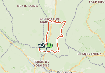
Randonnée Marche de 10,3 km à découvrir à Grand Est, Vosges, Gerbépal. Cette randonnée est proposée par Emmanuel Remy.
Description
Belle balade de forêts en prairies. La pause à la chapelle Sainte-Anne classée monument historique offre l'agrément d'un site remarquable.
Points d'intérêt
Localisation
Pays :
France
Région :
Grand Est
Département/Province :
Vosges
Commune :
Gerbépal
Localité :
Unknown
Départ:(Dec)
Départ:(UTM)
344041 ; 5329411 (32U) N.
Commentaires
Randonnées à proximité
![Randonnée Marche Gérardmer - gerardmer - la mauselaine . tête grauvelin . Roche boquet . croix claudé . hautes Vannes . la mauselaine - Photo](https://media.geolcdn.com/t/375/260/52e7d67b-2c25-481b-9a23-f7923e7ada1d.jpg&format=jpg&maxdim=2)
![Marche Marche](https://static1.geolcdn.com/sitytour/trail-icons/101.png)
gerardmer - la mauselaine . tête grauvelin . Roche boquet . croix claudé . ha...
Marche
Très facile
(1)
Gérardmer,
Grand Est,
Vosges,
France
![](/images/other/stat-length.png)
11,3 km | 16,2 km-effort
3h 42min
![](https://static1.geolcdn.com/siteimages/upload/files/16400158638029165_repeat_loop_refresh_sync_direction_icon.png)
Oui
![Randonnée Marche nordique Gérardmer - ramonchamp. observatoire de merelle, saut de la bourrique - Photo](https://media.geolcdn.com/t/375/260/b9b6a61e-3e1c-46cb-91c9-2c5e6825ee89.jpg&format=jpg&maxdim=2)
![Marche nordique Marche nordique](https://static1.geolcdn.com/sitytour/trail-icons/102.png)
ramonchamp. observatoire de merelle, saut de la bourrique
Marche nordique
Difficile
(1)
Gérardmer,
Grand Est,
Vosges,
France
![](/images/other/stat-length.png)
11,1 km | 15,8 km-effort
3h 30min
![](https://static1.geolcdn.com/siteimages/upload/files/16400158638029165_repeat_loop_refresh_sync_direction_icon.png)
Oui
![Randonnée Marche Ban-sur-Meurthe-Clefcy - La vallée de Belbriette - Ban-sur-Meurthe-Clefcy - Photo](https://media.geolcdn.com/t/375/260/ext.jpg?maxdim=2&url=https%3A%2F%2Fservices.sitytrail.com%2FGeolivesWS%2FDownloadMedia.ashx%3FTrailID%3D172951%26Media%3D14431_5.jpg)
![Marche Marche](https://static1.geolcdn.com/sitytour/trail-icons/101.png)
La vallée de Belbriette - Ban-sur-Meurthe-Clefcy
Marche
Moyen
(2)
Ban-sur-Meurthe-Clefcy,
Grand Est,
Vosges,
France
![](/images/other/stat-length.png)
9,8 km | 12,6 km-effort
2h 30min
![](https://static1.geolcdn.com/siteimages/upload/files/16400158638029165_repeat_loop_refresh_sync_direction_icon.png)
Oui
![Randonnée Marche Gérardmer - La Tête de Mérelle - Photo](https://media.geolcdn.com/t/375/260/ext.jpg?maxdim=2&url=https%3A%2F%2Fservices.sitytrail.com%2FGeolivesWS%2FDownloadMedia.ashx%3FTrailID%3D110294%26Media%3D5711_6.jpg)
![Marche Marche](https://static1.geolcdn.com/sitytour/trail-icons/101.png)
La Tête de Mérelle
Marche
Moyen
(5)
Gérardmer,
Grand Est,
Vosges,
France
![](/images/other/stat-length.png)
4,7 km | 9 km-effort
2h 30min
![](https://static1.geolcdn.com/siteimages/upload/files/16400158638029165_repeat_loop_refresh_sync_direction_icon.png)
Oui
![Randonnée Marche Gérardmer - 2018 05 24 obs Merelle - Photo](https://media.geolcdn.com/t/375/260/ext.jpg?maxdim=2&url=https%3A%2F%2Fservices.sitytrail.com%2FGeolivesWS%2FDownloadMedia.ashx%3FTrailID%3D973101%26Media%3Dfix__20180524120350.jpg)
![Marche Marche](https://static1.geolcdn.com/sitytour/trail-icons/101.png)
2018 05 24 obs Merelle
Marche
Moyen
(3)
Gérardmer,
Grand Est,
Vosges,
France
![](/images/other/stat-length.png)
11,5 km | 16,3 km-effort
4h 40min
![](https://static1.geolcdn.com/siteimages/upload/files/16400158638029165_repeat_loop_refresh_sync_direction_icon.png)
Oui
![Randonnée Marche Xonrupt-Longemer - 23-08-17 Lac Longemer - Lispach - Photo](https://media.geolcdn.com/t/375/260/ext.jpg?maxdim=2&url=https%3A%2F%2Fservices.sitytrail.com%2FGeolivesWS%2FDownloadMedia.ashx%3FTrailID%3D815971%26Media%3Dfix__20170823133945.jpg)
![Marche Marche](https://static1.geolcdn.com/sitytour/trail-icons/101.png)
23-08-17 Lac Longemer - Lispach
Marche
Moyen
(1)
Xonrupt-Longemer,
Grand Est,
Vosges,
France
![](/images/other/stat-length.png)
7 km | 12,1 km-effort
2h 13min
![](https://static1.geolcdn.com/siteimages/upload/files/16400158638029165_repeat_loop_refresh_sync_direction_icon.png)
Oui
![Randonnée Marche Xonrupt-Longemer - Le Hohneck et le sentier des roches - Du lac de Longemer au lac de Schiessrothried - Photo](https://media.geolcdn.com/t/375/260/ext.jpg?maxdim=2&url=https%3A%2F%2Fservices.sitytrail.com%2FGeolivesWS%2FDownloadMedia.ashx%3FTrailID%3D109636%26Media%3D4277_1.jpg)
![Marche Marche](https://static1.geolcdn.com/sitytour/trail-icons/101.png)
Le Hohneck et le sentier des roches - Du lac de Longemer au lac de Schiessrot...
Marche
Difficile
(1)
Xonrupt-Longemer,
Grand Est,
Vosges,
France
![](/images/other/stat-length.png)
15,7 km | 28 km-effort
7h 0min
![](https://static1.geolcdn.com/siteimages/upload/files/16400158638029165_repeat_loop_refresh_sync_direction_icon.png)
Non
![Randonnée Raquettes à neige Xonrupt-Longemer - Tour du Lispach - Longemer - Photo](https://media.geolcdn.com/t/375/260/ext.jpg?maxdim=2&url=https%3A%2F%2Fservices.sitytrail.com%2FGeolivesWS%2FDownloadMedia.ashx%3FTrailID%3D104732%26Media%3D8157_2.jpg)
![Raquettes à neige Raquettes à neige](https://static1.geolcdn.com/sitytour/trail-icons/504.png)
Tour du Lispach - Longemer
Raquettes à neige
Moyen
(2)
Xonrupt-Longemer,
Grand Est,
Vosges,
France
![](/images/other/stat-length.png)
3,2 km | 6,6 km-effort
2h 0min
![](https://static1.geolcdn.com/siteimages/upload/files/16400158638029165_repeat_loop_refresh_sync_direction_icon.png)
Oui
![Randonnée Marche Xonrupt-Longemer - Le tour du lac de longemer - Photo](https://media.geolcdn.com/t/375/260/f9d25791-a364-42ef-a096-c858c8a7f6bb.jpg&format=jpg&maxdim=2)
![Marche Marche](https://static1.geolcdn.com/sitytour/trail-icons/101.png)
Le tour du lac de longemer
Marche
Moyen
Xonrupt-Longemer,
Grand Est,
Vosges,
France
![](/images/other/stat-length.png)
5,2 km | 6,1 km-effort
1h 22min
![](https://static1.geolcdn.com/siteimages/upload/files/16400158638029165_repeat_loop_refresh_sync_direction_icon.png)
Oui