![](/images/other/stat-length.png)
![Randonnée Marche Angoulême - De saint Cybard à Fléac - Photo](https://media.geolcdn.com/t/1900/400/ext.pjpeg?maxdim=2&url=https%3A%2F%2Fservices.sitytrail.com%2FGeolivesWS%2FDownloadMedia.ashx%3FTrailID%3D383416%26Media%3Dfix__20150205155304.jpg)
De saint Cybard à Fléac
alainjoseph6
Utilisateur
![Longueur](/images/other/stat-length.png)
Longueur
11,4 km
![Altitude max](https://static1.geolcdn.com/siteimages/upload/files/1508320355ic_sort_altitude_max_24dp.png)
Altitude max
75 m
![Dénivelé positif](https://static1.geolcdn.com/siteimages/upload/files/1508320355ic_sort_den_pos_24dp.png)
Dénivelé positif
156 m
![Km-Effort](/images/other/stat-length.png)
Km-Effort
13,5 km
![Altitude min](https://static1.geolcdn.com/siteimages/upload/files/1508320355ic_sort_altitude_min_24dp.png)
Altitude min
26 m
![Dénivelé négatif](https://static1.geolcdn.com/siteimages/upload/files/1508320355ic_sort_den_neg_24dp.png)
Dénivelé négatif
153 m
![Boucle](https://static1.geolcdn.com/siteimages/upload/files/16400158638029165_repeat_loop_refresh_sync_direction_icon.png)
Boucle
Non
Date de création :
2015-02-08 00:00:00.0
Dernière modification :
2015-02-08 00:00:00.0
![Marche](https://static1.geolcdn.com/sitytour/trail-icons/101.png)
2h55
Difficulté : Inconnu
![Scannez ce code QR pour ouvrir la randonnée dans l'application SityTrail](https://capi.geolives.com/qq0zvz2zws4bq2lad0pu/sitytour/trails/383416/qr.png?size=200)
Application GPS de randonnée GRATUITE
À propos
Randonnée Marche de 11,4 km à découvrir à Nouvelle-Aquitaine, Charente, Angoulême. Cette randonnée est proposée par alainjoseph6.
Description
Une ballade au bord de la Charente jusqu'à la Mairie de Fléac, retour en bus jusqu'au jardin vert et descente à pieds place Mulack
Localisation
Pays :
France
Région :
Nouvelle-Aquitaine
Département/Province :
Charente
Commune :
Angoulême
Localité :
Unknown
Départ:(Dec)
Départ:(UTM)
277916 ; 5059553 (31T) N.
Commentaires
Randonnées à proximité
![Randonnée Marche Fléac - Rando-ballade le long de la Charente au départ de Fléac - Photo](https://media.geolcdn.com/t/375/260/4c5e8a21-a383-4e32-b8cd-d665e2b7cb10.jpg&format=jpg&maxdim=2)
![Marche Marche](https://static1.geolcdn.com/sitytour/trail-icons/101.png)
Rando-ballade le long de la Charente au départ de Fléac
Marche
Facile
Fléac,
Nouvelle-Aquitaine,
Charente,
France
![](/images/other/stat-length.png)
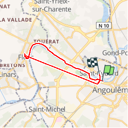
10 km | 11,5 km-effort
2h 26min
![](https://static1.geolcdn.com/siteimages/upload/files/16400158638029165_repeat_loop_refresh_sync_direction_icon.png)
Oui
![Randonnée Marche Angoulême - La Coulée Verte à Angoulème - Photo](https://media.geolcdn.com/t/375/260/ext.jpg?maxdim=2&url=https%3A%2F%2Fstatic1.geolcdn.com%2Fsiteimages%2Fupload%2Ffiles%2F1553511878bg_sport_marche.png)
![Marche Marche](https://static1.geolcdn.com/sitytour/trail-icons/101.png)
La Coulée Verte à Angoulème
Marche
Moyen
(1)
Angoulême,
Nouvelle-Aquitaine,
Charente,
France
![](/images/other/stat-length.png)
21 km | 25 km-effort
3h 0min
![](https://static1.geolcdn.com/siteimages/upload/files/16400158638029165_repeat_loop_refresh_sync_direction_icon.png)
Oui
![Randonnée Marche Angoulême - La rando d'Angoulême entre ville et campagne - Photo](https://media.geolcdn.com/t/375/260/85816ded-d784-45f0-a081-8c46f463d72d.jpg&format=jpg&maxdim=2)
![Marche Marche](https://static1.geolcdn.com/sitytour/trail-icons/101.png)
La rando d'Angoulême entre ville et campagne
Marche
Moyen
Angoulême,
Nouvelle-Aquitaine,
Charente,
France
![](/images/other/stat-length.png)
8,1 km | 9,9 km-effort
2h 59min
![](https://static1.geolcdn.com/siteimages/upload/files/16400158638029165_repeat_loop_refresh_sync_direction_icon.png)
Oui
![Randonnée Marche La Couronne - La balade de L'Oisellerie à La couronne - Photo](https://media.geolcdn.com/t/375/260/30782151-5105-401e-bfd4-75f95c65cb3d.jpg&format=jpg&maxdim=2)
![Marche Marche](https://static1.geolcdn.com/sitytour/trail-icons/101.png)
La balade de L'Oisellerie à La couronne
Marche
Très facile
La Couronne,
Nouvelle-Aquitaine,
Charente,
France
![](/images/other/stat-length.png)
7 km | 8 km-effort
2h 15min
![](https://static1.geolcdn.com/siteimages/upload/files/16400158638029165_repeat_loop_refresh_sync_direction_icon.png)
Oui
![Randonnée Marche Puymoyen - Puymoyen vallée des eaux claires par centre équestre élevage de cerfs - Photo](https://media.geolcdn.com/t/375/260/7be0dd57-0a78-479d-9db8-c66cc47fde9f.jpg&format=jpg&maxdim=2)
![Marche Marche](https://static1.geolcdn.com/sitytour/trail-icons/101.png)
Puymoyen vallée des eaux claires par centre équestre élevage de cerfs
Marche
Facile
(1)
Puymoyen,
Nouvelle-Aquitaine,
Charente,
France
![](/images/other/stat-length.png)
10,2 km | 13,1 km-effort
2h 29min
![](https://static1.geolcdn.com/siteimages/upload/files/16400158638029165_repeat_loop_refresh_sync_direction_icon.png)
Oui
![Randonnée Marche Angoulême - La découverte d'Angoulême en partant du parc de Fregneuil - Photo](https://media.geolcdn.com/t/375/260/ext.jpg?maxdim=2&url=https%3A%2F%2Fservices.sitytrail.com%2FGeolivesWS%2FDownloadMedia.ashx%3FTrailID%3D848534%26Media%3Dfix__20171019161538.jpg)
![Marche Marche](https://static1.geolcdn.com/sitytour/trail-icons/101.png)
La découverte d'Angoulême en partant du parc de Fregneuil
Marche
Facile
Angoulême,
Nouvelle-Aquitaine,
Charente,
France
![](/images/other/stat-length.png)
8,9 km | 10,5 km-effort
2h 58min
![](https://static1.geolcdn.com/siteimages/upload/files/16400158638029165_repeat_loop_refresh_sync_direction_icon.png)
Oui
![Randonnée Marche Fléac - Les écluses de Fléac et Linars - Photo](https://media.geolcdn.com/t/375/260/ext.jpg?maxdim=2&url=https%3A%2F%2Fservices.sitytrail.com%2FGeolivesWS%2FDownloadMedia.ashx%3FTrailID%3D727759%26Media%3Dfix__20170406161201.jpg)
![Marche Marche](https://static1.geolcdn.com/sitytour/trail-icons/101.png)
Les écluses de Fléac et Linars
Marche
Très facile
Fléac,
Nouvelle-Aquitaine,
Charente,
France
![](/images/other/stat-length.png)
10,1 km | 11,4 km-effort
2h 30min
![](https://static1.geolcdn.com/siteimages/upload/files/16400158638029165_repeat_loop_refresh_sync_direction_icon.png)
Oui
![Randonnée Autre activité Soyaux - ff - Photo](https://media.geolcdn.com/t/375/260/ext.jpg?maxdim=2&url=https%3A%2F%2Fstatic1.geolcdn.com%2Fsiteimages%2Fupload%2Ffiles%2F1545311037marcheuse_200dpi.jpg)
![Autre activité Autre activité](https://static1.geolcdn.com/sitytour/trail-icons/900.png)
ff
Autre activité
Très facile
(2)
Soyaux,
Nouvelle-Aquitaine,
Charente,
France
![](/images/other/stat-length.png)
12,9 km | 15,5 km-effort
2h 36min
![](https://static1.geolcdn.com/siteimages/upload/files/16400158638029165_repeat_loop_refresh_sync_direction_icon.png)
Oui
![Randonnée Marche Puymoyen - Puymoyen, vallée des eaux-claires - Photo](https://media.geolcdn.com/t/375/260/ext.jpg?maxdim=2&url=https%3A%2F%2Fservices.sitytrail.com%2FGeolivesWS%2FDownloadMedia.ashx%3FTrailID%3D481379%26Media%3D20151008153312.jpg)
![Marche Marche](https://static1.geolcdn.com/sitytour/trail-icons/101.png)
Puymoyen, vallée des eaux-claires
Marche
Facile
(1)
Puymoyen,
Nouvelle-Aquitaine,
Charente,
France
![](/images/other/stat-length.png)
9,6 km | 11,9 km-effort
2h 50min
![](https://static1.geolcdn.com/siteimages/upload/files/16400158638029165_repeat_loop_refresh_sync_direction_icon.png)
Oui