Randonnée Marche Commune de Lastros - L’Astrid - Photo
 cobut.jp@gmail.com
cobut.jp@gmail.com

Utilisateur

© OpenStreetMap contributors
Longueur
Longueur
10,9 km
Altitude max
Altitude max
609 m
Dénivelé positif
Dénivelé positif
408 m
Km-Effort
Km-Effort  
16,4 km
Altitude min
Altitude min
232 m
Dénivelé négatif
Dénivelé négatif
413 m
Boucle
Boucle
Oui
Date de création :
2023-10-02 06:57:42.0
Dernière modification :
2023-10-02 13:55:54.729

(0 Avis)

Marche
Marche
6h57
Difficulté : Difficile

Scannez ce code QR pour ouvrir la randonnée dans l'application SityTrail

Application GPS de randonnée GRATUITE

Logo SityTrail SityTrail

IGN / Instituts géographiques

Télécharger SityTrail sur l'App Store Télécharger SityTrail sur Google Play

Logo SityTrail SityTrail World

Le monde est à vous

Télécharger SityTrail sur l'App Store Télécharger SityTrail sur Google Play Télécharger SityTrail sur Huawei AppGallery

À propos

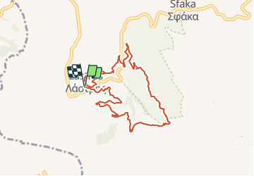
Randonnée Marche de 10,9 km à découvrir à Région Crète, Περιφερειακή Ενότητα Λασιθίου, Commune de Lastros. Cette randonnée est proposée par cobut.jp@gmail.com.

Description

L’astronaute Vou

Profil altimétrique

Localisation

Pays :
Grèce
Région :
Région Crète
Département/Province :
Περιφερειακή Ενότητα Λασιθίου
Commune :
Commune de Lastros
Localité :
Unknown
Départ:(Dec)
Départ:(UTM)
399745 ; 3889017 (35S) N.

Randonnées à proximité

Randonnée Marche Inconnu - Gorge :de Messonas Kavousi  - Photo
Marche
cobut.jp@gmail.com

Marche

Très difficile
Inconnu, Région Crète, Περιφερειακή Ενότητα Λασιθίου, Grèce
22 km | 34 km-effort
5h 58min
Non
Randonnée Marche Commune de Lastros - L’astronaute Voo - Photo
Marche
cobut.jp@gmail.com

Marche

Difficile
Commune de Lastros, Région Crète, Περιφερειακή Ενότητα Λασιθίου, Grèce
9,9 km | 16,7 km-effort
4h 41min
Non
Randonnée Marche Commune de Sfaka - Scalaire toulouti - Photo
Marche
cobut.jp@gmail.com

Marche

Très difficile
Commune de Sfaka, Région Crète, Περιφερειακή Ενότητα Λασιθίου, Grèce
16,3 km | 24 km-effort
6h 52min
Non
Randonnée Marche  - Crête 2 eme jour névadas - Photo
Marche
CriCri

Marche

Très difficile
, Région Crète, Περιφερειακή Ενότητα Λασιθίου, Grèce
13,3 km | 23 km-effort
3h 37min
Oui
Randonnée Marche Inconnu - gorges de Mesonas chapelle st nikalas - Photo
Marche
Lauvalarnoult

Marche

Difficile
Inconnu, Région Crète, Περιφερειακή Ενότητα Λασιθίου, Grèce
7,4 km | 14,7 km-effort
2h 49min
Oui


Fermer
Mes abonnements