Randonnée Marche Maintenon - Maintenon - Boucle de l'Eure Nogent Le Roi - Photo

Maintenon - Boucle de l'Eure Nogent Le Roi

partout a pied et en moto

© OpenStreetMap contributors
Longueur
Longueur
18,7 km
Altitude max
Altitude max
144 m
Dénivelé positif
Dénivelé positif
186 m
Km-Effort
Km-Effort  
21 km
Altitude min
Altitude min
94 m
Dénivelé négatif
Dénivelé négatif
187 m
Boucle
Boucle
Oui
Date de création :
2023-10-02 08:43:42.35
Dernière modification :
2023-10-02 16:40:03.095

(0 Avis)

Marche
Marche
4h48
Difficulté : Très difficile

Scannez ce code QR pour ouvrir la randonnée dans l'application SityTrail

Application GPS de randonnée GRATUITE

Logo SityTrail SityTrail

IGN / Instituts géographiques

Télécharger SityTrail sur l'App Store Télécharger SityTrail sur Google Play

Logo SityTrail SityTrail World

Le monde est à vous

Télécharger SityTrail sur l'App Store Télécharger SityTrail sur Google Play Télécharger SityTrail sur Huawei AppGallery

À propos

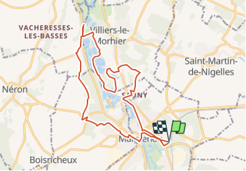
Randonnée Marche de 18,7 km à découvrir à Centre-Val de Loire, Eure-et-Loir, Maintenon. Cette randonnée est proposée par les randos d'Olivier.

Profil altimétrique

Points d'intérêt

Point d'intérêt Pierres - Rue Jean Monnet - Photo
olivieraron
Point d'intérêt Pierres - Embranchement sortie du bois - Photo
olivieraron
Point d'intérêt Pierres - Cimetière - Photo
olivieraron
PIERRES 
Point d'intérêt Nogent-le-Roi - D101.3 - Photo
olivieraron
NOGENT-LE-ROI 
Point d'intérêt Nogent-le-Roi - Nouvelle déviation - Photo
olivieraron
NOGENT-LE-ROI 
Point d'intérêt Nogent-le-Roi - Château de Nogent-le-Roi - Photo
olivieraron
Point d'intérêt Nogent-le-Roi - Maisons à colombage - Photo
olivieraron
NOGENT-LE-ROI 
Point d'intérêt Villiers-le-Morhier - Petit sentier - Photo
olivieraron
VILLIERS-LE-MORHIER 
Point d'intérêt Villiers-le-Morhier - A droite après le pont sur la - Photo
olivieraron
VILLIERS-LE-MORHIER 
Point d'intérêt Villiers-le-Morhier - Ancien lavoir - Photo
olivieraron
VILLIERS-LE-MORHIER 
Point d'intérêt Maintenon - Parking des bords de la - Photo
olivieraron

Localisation

Pays :
France
Région :
Centre-Val de Loire
Département/Province :
Eure-et-Loir
Commune :
Maintenon
Localité :
Unknown
Départ:(UTM)
396140 ; 5382306 (31U) N.

Randonnées à proximité

Randonnée V.T.T. Maintenon - Bois et vallées - Maintenon - Photo
V.T.T.
tracegps

V.T.T.

Facile
(1)
Maintenon, Centre-Val de Loire, Eure-et-Loir, France
12,7 km | 14,7 km-effort
1h 0min
Oui
Randonnée Marche Saint-Piat - 20200611St Piat - Photo
Marche
Jeanclaudebic

Marche

Très facile
(1)
Saint-Piat, Centre-Val de Loire, Eure-et-Loir, France
10,6 km | 12,5 km-effort
2h 8min
Oui
Randonnée Marche Maintenon - maintenon - Photo
Marche
topophil

Marche

Très facile
(1)
Maintenon, Centre-Val de Loire, Eure-et-Loir, France
14 km | 16,3 km-effort
3h 5min
Oui
Randonnée Marche Maintenon - Bois et vallées - Maintenon - Photo
Marche
tracegps

Marche

Difficile
(3)
Maintenon, Centre-Val de Loire, Eure-et-Loir, France
12,7 km | 14,7 km-effort
3h 10min
Oui
Randonnée Marche Maintenon - Maintenon APL - Photo
Marche
jctbis

Marche

Moyen
Maintenon, Centre-Val de Loire, Eure-et-Loir, France
11,5 km | 12,8 km-effort
2h 38min
Oui
Randonnée Marche Hanches - Hanches  - Photo
Marche
jctbis

Marche

Facile
Hanches, Centre-Val de Loire, Eure-et-Loir, France
11,8 km | 13,2 km-effort
2h 57min
Oui
Randonnée sport Saint-Piat - Parcours Thierry, Geille Saint-Piat - Photo
sport
ezola

sport

Très facile
Saint-Piat, Centre-Val de Loire, Eure-et-Loir, France
23 km | 27 km-effort
Inconnu
Oui
Randonnée V.T.T. Hanches - hanches Droue sur Drouette st Hilarion - Photo
V.T.T.
topophil

V.T.T.

Difficile
Hanches, Centre-Val de Loire, Eure-et-Loir, France
31 km | 36 km-effort
3h 12min
Oui
Randonnée Marche nordique Saint-Piat - APL St Piat  - Photo
Marche nordique
jctbis

Marche nordique

Facile
Saint-Piat, Centre-Val de Loire, Eure-et-Loir, France
9,6 km | 11,5 km-effort
2h 1min
Oui


Fermer
Mes abonnements