![](/images/other/stat-length.png)
![Randonnée Marche Turnhout - De weiden en akkers in het noorden van de provincie Antwerpen - Photo](https://media.geolcdn.com/t/1900/400/ext.pjpeg?maxdim=2&url=https%3A%2F%2Fstatic1.geolcdn.com%2Fsiteimages%2Fupload%2Ffiles%2F1553511878bg_sport_marche.png)
De weiden en akkers in het noorden van de provincie Antwerpen
LucThomaere
Utilisateur
![Longueur](/images/other/stat-length.png)
Longueur
23 km
![Altitude max](https://static1.geolcdn.com/siteimages/upload/files/1508320355ic_sort_altitude_max_24dp.png)
Altitude max
35 m
![Dénivelé positif](https://static1.geolcdn.com/siteimages/upload/files/1508320355ic_sort_den_pos_24dp.png)
Dénivelé positif
142 m
![Km-Effort](/images/other/stat-length.png)
Km-Effort
25 km
![Altitude min](https://static1.geolcdn.com/siteimages/upload/files/1508320355ic_sort_altitude_min_24dp.png)
Altitude min
17 m
![Dénivelé négatif](https://static1.geolcdn.com/siteimages/upload/files/1508320355ic_sort_den_neg_24dp.png)
Dénivelé négatif
141 m
![Boucle](https://static1.geolcdn.com/siteimages/upload/files/16400158638029165_repeat_loop_refresh_sync_direction_icon.png)
Boucle
Non
Date de création :
2023-10-01 09:38:09.0
Dernière modification :
2024-02-12 09:15:58.71
![Marche](https://static1.geolcdn.com/sitytour/trail-icons/101.png)
5h45
Difficulté : Moyen
![Scannez ce code QR pour ouvrir la randonnée dans l'application SityTrail](https://capi.geolives.com/qq0zvz2zws4bq2lad0pu/sitytour/trails/3825100/qr.png?size=200)
Application GPS de randonnée GRATUITE
À propos
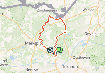
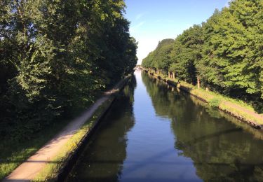
Randonnée Marche de 23 km à découvrir à Flandre, Anvers, Turnhout. Cette randonnée est proposée par LucThomaere.
Description
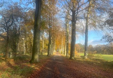
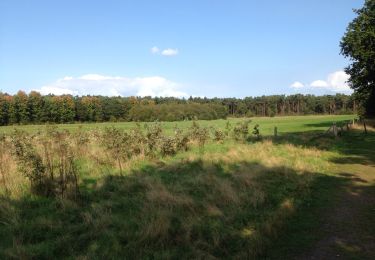
Vertrekken van op de parking van de begraafplaats van Turnhout. Lange, open wandeling langs boerderijen, weiden en akkers. Weinig bos, veel panorama's.
Localisation
Pays :
Belgique
Région :
Flandre
Département/Province :
Anvers
Commune :
Turnhout
Localité :
Unknown
Départ:(Dec)
Départ:(UTM)
633266 ; 5689166 (31U) N.
Commentaires
Randonnées à proximité
![Randonnée Marche Turnhout - 67.019 Vosselaar - Vossenpad - Photo](https://media.geolcdn.com/t/375/260/34337170-0300-429d-beae-53c4ef6b1099.jpg&format=jpg&maxdim=2)
![Marche Marche](https://static1.geolcdn.com/sitytour/trail-icons/101.png)
67.019 Vosselaar - Vossenpad
Marche
Moyen
(1)
Turnhout,
Flandre,
Anvers,
Belgique
![](/images/other/stat-length.png)
13,1 km | 14,2 km-effort
3h 41min
![](https://static1.geolcdn.com/siteimages/upload/files/16400158638029165_repeat_loop_refresh_sync_direction_icon.png)
Non
![Randonnée Marche Vosselaar - Vosselaar, 6,7 km - Photo](https://media.geolcdn.com/t/375/260/ext.jpg?maxdim=2&url=https%3A%2F%2Fservices.sitytrail.com%2FGeolivesWS%2FDownloadMedia.ashx%3FTrailID%3D351558%26Media%3D20141005151937.jpg)
![Marche Marche](https://static1.geolcdn.com/sitytour/trail-icons/101.png)
Vosselaar, 6,7 km
Marche
Très facile
Vosselaar,
Flandre,
Anvers,
Belgique
![](/images/other/stat-length.png)
6,6 km | 7,2 km-effort
1h 33min
![](https://static1.geolcdn.com/siteimages/upload/files/16400158638029165_repeat_loop_refresh_sync_direction_icon.png)
Oui
![Randonnée Marche Lille - VOSSELAAR: wandeling Rood - Photo](https://media.geolcdn.com/t/375/260/ext.jpg?maxdim=2&url=https%3A%2F%2Fservices.sitytrail.com%2FGeolivesWS%2FDownloadMedia.ashx%3FTrailID%3D347217%26Media%3D20140921152135.jpg)
![Marche Marche](https://static1.geolcdn.com/sitytour/trail-icons/101.png)
VOSSELAAR: wandeling Rood
Marche
Très facile
Lille,
Flandre,
Anvers,
Belgique
![](/images/other/stat-length.png)
4 km | 4,4 km-effort
52min
![](https://static1.geolcdn.com/siteimages/upload/files/16400158638029165_repeat_loop_refresh_sync_direction_icon.png)
Oui
![Randonnée Marche Turnhout - 35.241 Turnhout - Geleg - Photo](https://media.geolcdn.com/t/375/260/e9defe88-ff10-43a8-9951-d09d9c63e8b5.jpg&format=jpg&maxdim=2)
![Marche Marche](https://static1.geolcdn.com/sitytour/trail-icons/101.png)
35.241 Turnhout - Geleg
Marche
Moyen
(1)
Turnhout,
Flandre,
Anvers,
Belgique
![](/images/other/stat-length.png)
24 km | 25 km-effort
5h 26min
![](https://static1.geolcdn.com/siteimages/upload/files/16400158638029165_repeat_loop_refresh_sync_direction_icon.png)
Non
![Randonnée Marche Vosselaar - Kerstwandeling Vosselaar zuid 2020-2021 - Photo](https://media.geolcdn.com/t/375/260/ext.jpg?maxdim=2&url=https%3A%2F%2Fstatic1.geolcdn.com%2Fsiteimages%2Fupload%2Ffiles%2F1553511878bg_sport_marche.png)
![Marche Marche](https://static1.geolcdn.com/sitytour/trail-icons/101.png)
Kerstwandeling Vosselaar zuid 2020-2021
Marche
Vosselaar,
Flandre,
Anvers,
Belgique
![](/images/other/stat-length.png)
8 km | 8,6 km-effort
1h 26min
![](https://static1.geolcdn.com/siteimages/upload/files/16400158638029165_repeat_loop_refresh_sync_direction_icon.png)
Oui
![Randonnée Moteur Turnhout - a-belgie-van-de-penge-naar-grand-pachy-1 - Photo](https://media.geolcdn.com/t/375/260/ext.jpg?maxdim=2&url=https%3A%2F%2Fstatic1.geolcdn.com%2Fsiteimages%2Fupload%2Ffiles%2F15247431544x4.jpg)
![Moteur Moteur](https://static1.geolcdn.com/sitytour/trail-icons/400.png)
a-belgie-van-de-penge-naar-grand-pachy-1
Moteur
Très facile
Turnhout,
Flandre,
Anvers,
Belgique
![](/images/other/stat-length.png)
189 km | 236 km-effort
Inconnu
![](https://static1.geolcdn.com/siteimages/upload/files/16400158638029165_repeat_loop_refresh_sync_direction_icon.png)
Non
![Randonnée Moteur Beerse - a-belgie-rondje-beerse - Photo](https://media.geolcdn.com/t/375/260/ext.jpg?maxdim=2&url=https%3A%2F%2Fstatic1.geolcdn.com%2Fsiteimages%2Fupload%2Ffiles%2F15247431544x4.jpg)
![Moteur Moteur](https://static1.geolcdn.com/sitytour/trail-icons/400.png)
a-belgie-rondje-beerse
Moteur
Très facile
Beerse,
Flandre,
Anvers,
Belgique
![](/images/other/stat-length.png)
84 km | 90 km-effort
Inconnu
![](https://static1.geolcdn.com/siteimages/upload/files/16400158638029165_repeat_loop_refresh_sync_direction_icon.png)
Oui
![Randonnée Moteur Beerse - a-belgie-haven-antwerpen - Photo](https://media.geolcdn.com/t/375/260/ext.jpg?maxdim=2&url=https%3A%2F%2Fstatic1.geolcdn.com%2Fsiteimages%2Fupload%2Ffiles%2F15247431544x4.jpg)
![Moteur Moteur](https://static1.geolcdn.com/sitytour/trail-icons/400.png)
a-belgie-haven-antwerpen
Moteur
Très facile
(1)
Beerse,
Flandre,
Anvers,
Belgique
![](/images/other/stat-length.png)
120 km | 129 km-effort
Inconnu
![](https://static1.geolcdn.com/siteimages/upload/files/16400158638029165_repeat_loop_refresh_sync_direction_icon.png)
Oui
![Randonnée Moteur Turnhout - a-belgie-2de-damiaanroute - Photo](https://media.geolcdn.com/t/375/260/ext.jpg?maxdim=2&url=https%3A%2F%2Fstatic1.geolcdn.com%2Fsiteimages%2Fupload%2Ffiles%2F15247431544x4.jpg)
![Moteur Moteur](https://static1.geolcdn.com/sitytour/trail-icons/400.png)
a-belgie-2de-damiaanroute
Moteur
Très facile
Turnhout,
Flandre,
Anvers,
Belgique
![](/images/other/stat-length.png)
123 km | 133 km-effort
Inconnu
![](https://static1.geolcdn.com/siteimages/upload/files/16400158638029165_repeat_loop_refresh_sync_direction_icon.png)
Non