![](/images/other/stat-length.png)
![Randonnée Marche Rahart - Rahart - Photo](https://media.geolcdn.com/t/1900/400/f650ba70-4d58-496b-8e3a-7549b98be635.jpg&format=pjpeg&maxdim=2)
Rahart
guydu41
Utilisateur
![Longueur](/images/other/stat-length.png)
Longueur
8,1 km
![Altitude max](https://static1.geolcdn.com/siteimages/upload/files/1508320355ic_sort_altitude_max_24dp.png)
Altitude max
142 m
![Dénivelé positif](https://static1.geolcdn.com/siteimages/upload/files/1508320355ic_sort_den_pos_24dp.png)
Dénivelé positif
87 m
![Km-Effort](/images/other/stat-length.png)
Km-Effort
9,3 km
![Altitude min](https://static1.geolcdn.com/siteimages/upload/files/1508320355ic_sort_altitude_min_24dp.png)
Altitude min
108 m
![Dénivelé négatif](https://static1.geolcdn.com/siteimages/upload/files/1508320355ic_sort_den_neg_24dp.png)
Dénivelé négatif
87 m
![Boucle](https://static1.geolcdn.com/siteimages/upload/files/16400158638029165_repeat_loop_refresh_sync_direction_icon.png)
Boucle
Oui
Date de création :
2023-10-01 07:14:56.619
Dernière modification :
2023-10-01 14:02:42.199
![Marche](https://static1.geolcdn.com/sitytour/trail-icons/101.png)
2h06
Difficulté : Facile
![Scannez ce code QR pour ouvrir la randonnée dans l'application SityTrail](https://capi.geolives.com/qq0zvz2zws4bq2lad0pu/sitytour/trails/3824494/qr.png?size=200)
Application GPS de randonnée GRATUITE
À propos
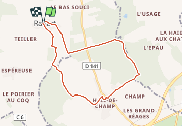
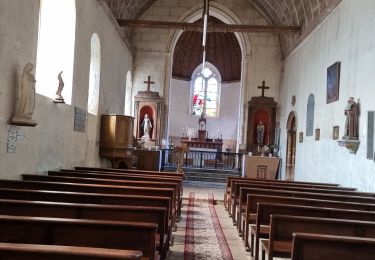
Randonnée Marche de 8,1 km à découvrir à Centre-Val de Loire, Loir-et-Cher, Rahart. Cette randonnée est proposée par guydu41.
Description
Boucle depuis un petit parking à Rahart.
Une partie de ce parcours emprunte un circuit balisé violet sur fond blanc par l'association "chemins et paysages".
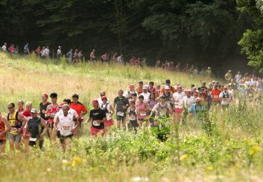
Les sentiers dans le Bois de l'Epau sont très beaux.
Localisation
Pays :
France
Région :
Centre-Val de Loire
Département/Province :
Loir-et-Cher
Commune :
Rahart
Localité :
Unknown
Départ:(Dec)
Départ:(UTM)
355419 ; 5303738 (31T) N.
Commentaires
Randonnées à proximité
![Randonnée Marche Lisle - Lisle - Bord du Loir - Photo](https://media.geolcdn.com/t/375/260/4f9116bd-eecc-48ec-adb9-fd3c5cad4087.jpg&format=jpg&maxdim=2)
![Marche Marche](https://static1.geolcdn.com/sitytour/trail-icons/101.png)
Lisle - Bord du Loir
Marche
Facile
Lisle,
Centre-Val de Loire,
Loir-et-Cher,
France
![](/images/other/stat-length.png)
8,9 km | 9,5 km-effort
2h 9min
![](https://static1.geolcdn.com/siteimages/upload/files/16400158638029165_repeat_loop_refresh_sync_direction_icon.png)
Oui
![Randonnée Marche Saint-Firmin-des-Prés - Saint-Firmin-des-Prés - Photo](https://media.geolcdn.com/t/375/260/a5813cc0-d151-48d6-b693-f67e132742f6.jpg&format=jpg&maxdim=2)
![Marche Marche](https://static1.geolcdn.com/sitytour/trail-icons/101.png)
Saint-Firmin-des-Prés
Marche
Facile
Saint-Firmin-des-Prés,
Centre-Val de Loire,
Loir-et-Cher,
France
![](/images/other/stat-length.png)
8,9 km | 9,9 km-effort
1h 58min
![](https://static1.geolcdn.com/siteimages/upload/files/16400158638029165_repeat_loop_refresh_sync_direction_icon.png)
Oui
![Randonnée Marche Lisle - Lisle - Bois de l'Epau - Photo](https://media.geolcdn.com/t/375/260/f2ea5793-eafb-48f8-8f49-2ef6ceea9d28.jpg&format=jpg&maxdim=2)
![Marche Marche](https://static1.geolcdn.com/sitytour/trail-icons/101.png)
Lisle - Bois de l'Epau
Marche
Facile
Lisle,
Centre-Val de Loire,
Loir-et-Cher,
France
![](/images/other/stat-length.png)
8,9 km | 10,2 km-effort
2h 19min
![](https://static1.geolcdn.com/siteimages/upload/files/16400158638029165_repeat_loop_refresh_sync_direction_icon.png)
Oui
![Randonnée Course à pied La Ville-aux-Clercs - Sur les Traces du Loup - La Ville aux Clercs - Photo](https://media.geolcdn.com/t/375/260/ext.jpg?maxdim=2&url=https%3A%2F%2Fservices.sitytrail.com%2FGeolivesWS%2FDownloadMedia.ashx%3FTrailID%3D317966%26Media%3D17408_3.jpg)
![Course à pied Course à pied](https://static1.geolcdn.com/sitytour/trail-icons/103.png)
Sur les Traces du Loup - La Ville aux Clercs
Course à pied
Difficile
La Ville-aux-Clercs,
Centre-Val de Loire,
Loir-et-Cher,
France
![](/images/other/stat-length.png)
31 km | 37 km-effort
3h 30min
![](https://static1.geolcdn.com/siteimages/upload/files/16400158638029165_repeat_loop_refresh_sync_direction_icon.png)
Oui
![Randonnée Marche Saint-Firmin-des-Prés - St Firmin Mjo - Photo](https://media.geolcdn.com/t/375/260/ext.jpg?maxdim=2&url=https%3A%2F%2Fstatic1.geolcdn.com%2Fsiteimages%2Fupload%2Ffiles%2F1553511878bg_sport_marche.png)
![Marche Marche](https://static1.geolcdn.com/sitytour/trail-icons/101.png)
St Firmin Mjo
Marche
Facile
Saint-Firmin-des-Prés,
Centre-Val de Loire,
Loir-et-Cher,
France
![](/images/other/stat-length.png)
16 km | 17,9 km-effort
3h 9min
![](https://static1.geolcdn.com/siteimages/upload/files/16400158638029165_repeat_loop_refresh_sync_direction_icon.png)
Oui
![Randonnée Marche Lisle - Rando de lisle - Photo](https://media.geolcdn.com/t/375/260/ext.jpg?maxdim=2&url=https%3A%2F%2Fstatic1.geolcdn.com%2Fsiteimages%2Fupload%2Ffiles%2F1553511878bg_sport_marche.png)
![Marche Marche](https://static1.geolcdn.com/sitytour/trail-icons/101.png)
Rando de lisle
Marche
Moyen
(1)
Lisle,
Centre-Val de Loire,
Loir-et-Cher,
France
![](/images/other/stat-length.png)
18,7 km | 21 km-effort
4h 21min
![](https://static1.geolcdn.com/siteimages/upload/files/16400158638029165_repeat_loop_refresh_sync_direction_icon.png)
Oui
![Randonnée Marche Busloup - Busloup - Photo](https://media.geolcdn.com/t/375/260/ext.jpg?maxdim=2&url=https%3A%2F%2Fstatic1.geolcdn.com%2Fsiteimages%2Fupload%2Ffiles%2F1553511878bg_sport_marche.png)
![Marche Marche](https://static1.geolcdn.com/sitytour/trail-icons/101.png)
Busloup
Marche
Facile
Busloup,
Centre-Val de Loire,
Loir-et-Cher,
France
![](/images/other/stat-length.png)
21 km | 25 km-effort
3h 8min
![](https://static1.geolcdn.com/siteimages/upload/files/16400158638029165_repeat_loop_refresh_sync_direction_icon.png)
Oui
![Randonnée Marche Vendôme - vendome - Photo](https://media.geolcdn.com/t/375/260/ext.jpg?maxdim=2&url=https%3A%2F%2Fstatic1.geolcdn.com%2Fsiteimages%2Fupload%2Ffiles%2F1553511878bg_sport_marche.png)
![Marche Marche](https://static1.geolcdn.com/sitytour/trail-icons/101.png)
vendome
Marche
Très facile
Vendôme,
Centre-Val de Loire,
Loir-et-Cher,
France
![](/images/other/stat-length.png)
5,6 km | 6,3 km-effort
55min
![](https://static1.geolcdn.com/siteimages/upload/files/16400158638029165_repeat_loop_refresh_sync_direction_icon.png)
Oui