![](/images/other/stat-length.png)
![Randonnée Marche Münchweiler an der Rodalb - Felsenwald - Photo](https://media.geolcdn.com/t/1900/400/405030d7-97d3-4f5f-ba79-d025ac7a07cb.jpg&format=pjpeg&maxdim=2)
Felsenwald
oscar1
Utilisateur
![Longueur](/images/other/stat-length.png)
Longueur
11 km
![Altitude max](https://static1.geolcdn.com/siteimages/upload/files/1508320355ic_sort_altitude_max_24dp.png)
Altitude max
423 m
![Dénivelé positif](https://static1.geolcdn.com/siteimages/upload/files/1508320355ic_sort_den_pos_24dp.png)
Dénivelé positif
357 m
![Km-Effort](/images/other/stat-length.png)
Km-Effort
15,7 km
![Altitude min](https://static1.geolcdn.com/siteimages/upload/files/1508320355ic_sort_altitude_min_24dp.png)
Altitude min
321 m
![Dénivelé négatif](https://static1.geolcdn.com/siteimages/upload/files/1508320355ic_sort_den_neg_24dp.png)
Dénivelé négatif
355 m
![Boucle](https://static1.geolcdn.com/siteimages/upload/files/16400158638029165_repeat_loop_refresh_sync_direction_icon.png)
Boucle
Oui
Date de création :
2023-09-27 08:27:22.53
Dernière modification :
2023-10-02 19:48:34.31
![Marche](https://static1.geolcdn.com/sitytour/trail-icons/101.png)
3h34
Difficulté : Difficile
![Scannez ce code QR pour ouvrir la randonnée dans l'application SityTrail](https://capi.geolives.com/qq0zvz2zws4bq2lad0pu/sitytour/trails/3820218/qr.png?size=200)
Application GPS de randonnée GRATUITE
À propos
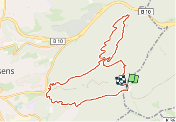
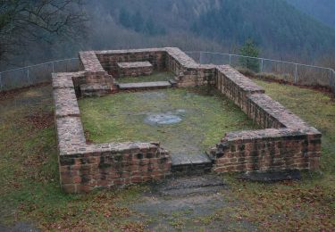
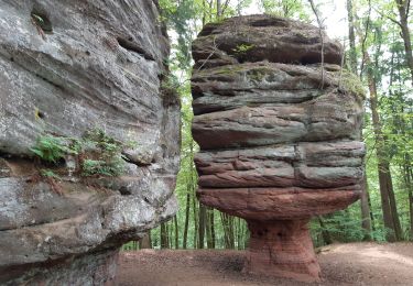
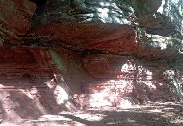
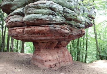
Randonnée Marche de 11 km à découvrir à Rhénanie-Palatinat, Südwestpfalz, Münchweiler an der Rodalb. Cette randonnée est proposée par oscar1.
Description
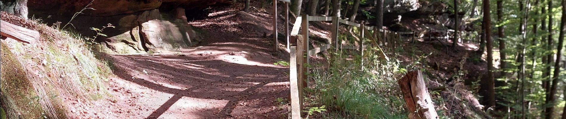
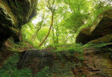
Belle petite balade sans difficultés particulières qui permet de voir de nombreux rochers. Suivre le flèchage panneau Felsenwald, comme sur la photo.
Localisation
Pays :
Allemagne
Région :
Rhénanie-Palatinat
Département/Province :
Südwestpfalz
Commune :
Münchweiler an der Rodalb
Localité :
Unknown
Départ:(Dec)
Départ:(UTM)
402031 ; 5450046 (32U) N.
Commentaires
Randonnées à proximité
![Randonnée A pied - Teufelspfad - Photo](https://media.geolcdn.com/t/375/260/72c485d3-1a1c-4db9-8c42-8274cd2b76d3.jpeg&format=jpg&maxdim=2)
![A pied A pied](https://static1.geolcdn.com/sitytour/trail-icons/100.png)
Teufelspfad
A pied
Facile
,
Rhénanie-Palatinat,
Pirmasens,
Allemagne
![](/images/other/stat-length.png)
6,2 km | 8,4 km-effort
1h 54min
![](https://static1.geolcdn.com/siteimages/upload/files/16400158638029165_repeat_loop_refresh_sync_direction_icon.png)
Oui
![Randonnée A pied Münchweiler an der Rodalb - Felsenwaldtour - Photo](https://media.geolcdn.com/t/375/260/27ea1187-bd8b-4476-ae26-5025c4273908.jpeg&format=jpg&maxdim=2)
![A pied A pied](https://static1.geolcdn.com/sitytour/trail-icons/100.png)
Felsenwaldtour
A pied
Facile
Münchweiler an der Rodalb,
Rhénanie-Palatinat,
Südwestpfalz,
Allemagne
![](/images/other/stat-length.png)
13,3 km | 19,1 km-effort
4h 20min
![](https://static1.geolcdn.com/siteimages/upload/files/16400158638029165_repeat_loop_refresh_sync_direction_icon.png)
Oui
![Randonnée A pied Lemberg - Lemberger Rothenberg-Weg - Photo](https://media.geolcdn.com/t/375/260/707b9fb7-6276-4f2e-9888-5b78e2108006.jpeg&format=jpg&maxdim=2)
![A pied A pied](https://static1.geolcdn.com/sitytour/trail-icons/100.png)
Lemberger Rothenberg-Weg
A pied
Facile
Lemberg,
Rhénanie-Palatinat,
Südwestpfalz,
Allemagne
![](/images/other/stat-length.png)
9,4 km | 12,6 km-effort
2h 51min
![](https://static1.geolcdn.com/siteimages/upload/files/16400158638029165_repeat_loop_refresh_sync_direction_icon.png)
Oui
![Randonnée A pied Münchweiler an der Rodalb - Münchweiler Höhenwanderweg - Photo](https://media.geolcdn.com/t/375/260/bbd39193-5a66-4d9f-be64-d7d175ff56e8.jpeg&format=jpg&maxdim=2)
![A pied A pied](https://static1.geolcdn.com/sitytour/trail-icons/100.png)
Münchweiler Höhenwanderweg
A pied
Moyen
Münchweiler an der Rodalb,
Rhénanie-Palatinat,
Südwestpfalz,
Allemagne
![](/images/other/stat-length.png)
15,7 km | 22 km-effort
4h 59min
![](https://static1.geolcdn.com/siteimages/upload/files/16400158638029165_repeat_loop_refresh_sync_direction_icon.png)
Oui
![Randonnée A pied Lemberg - Lemberger Graf-Heinrich-Weg - Photo](https://media.geolcdn.com/t/375/260/1a275d3c-a618-441f-91f7-5b44c8024737.jpeg&format=jpg&maxdim=2)
![A pied A pied](https://static1.geolcdn.com/sitytour/trail-icons/100.png)
Lemberger Graf-Heinrich-Weg
A pied
Facile
Lemberg,
Rhénanie-Palatinat,
Südwestpfalz,
Allemagne
![](/images/other/stat-length.png)
11,7 km | 17,4 km-effort
3h 56min
![](https://static1.geolcdn.com/siteimages/upload/files/16400158638029165_repeat_loop_refresh_sync_direction_icon.png)
Oui
![Randonnée A pied Münchweiler an der Rodalb - DE-7 - Photo](https://media.geolcdn.com/t/375/260/070582bd-8e05-4f19-a255-4308f2490e36.jpeg&format=jpg&maxdim=2)
![A pied A pied](https://static1.geolcdn.com/sitytour/trail-icons/100.png)
DE-7
A pied
Facile
Münchweiler an der Rodalb,
Rhénanie-Palatinat,
Südwestpfalz,
Allemagne
![](/images/other/stat-length.png)
7,3 km | 9,8 km-effort
2h 13min
![](https://static1.geolcdn.com/siteimages/upload/files/16400158638029165_repeat_loop_refresh_sync_direction_icon.png)
Non
![Randonnée Marche Münchweiler an der Rodalb - Pirmasens - Felsenwald - Photo](https://media.geolcdn.com/t/375/260/5baf6c00-a6a3-46f6-9a28-4727ebd10360.jpg&format=jpg&maxdim=2)
![Marche Marche](https://static1.geolcdn.com/sitytour/trail-icons/101.png)
Pirmasens - Felsenwald
Marche
Moyen
Münchweiler an der Rodalb,
Rhénanie-Palatinat,
Südwestpfalz,
Allemagne
![](/images/other/stat-length.png)
14,2 km | 20 km-effort
4h 48min
![](https://static1.geolcdn.com/siteimages/upload/files/16400158638029165_repeat_loop_refresh_sync_direction_icon.png)
Oui
![Randonnée Marche Lemberg - lemberger rothenbergerweg - Photo](https://media.geolcdn.com/t/375/260/cddecaaf-a040-463d-9719-ab6f1d8c2ec4.jpg&format=jpg&maxdim=2)
![Marche Marche](https://static1.geolcdn.com/sitytour/trail-icons/101.png)
lemberger rothenbergerweg
Marche
Moyen
Lemberg,
Rhénanie-Palatinat,
Südwestpfalz,
Allemagne
![](/images/other/stat-length.png)
10,7 km | 14,3 km-effort
3h 12min
![](https://static1.geolcdn.com/siteimages/upload/files/16400158638029165_repeat_loop_refresh_sync_direction_icon.png)
Oui
![Randonnée Marche - Pirmasens - Felsenwald - Photo](https://media.geolcdn.com/t/375/260/3ba6f11f-1f49-416d-9c9b-6b8c23ffe125.jpg&format=jpg&maxdim=2)
![Marche Marche](https://static1.geolcdn.com/sitytour/trail-icons/101.png)
Pirmasens - Felsenwald
Marche
Moyen
,
Rhénanie-Palatinat,
Pirmasens,
Allemagne
![](/images/other/stat-length.png)
15,5 km | 22 km-effort
4h 29min
![](https://static1.geolcdn.com/siteimages/upload/files/16400158638029165_repeat_loop_refresh_sync_direction_icon.png)
Non