![](/images/other/stat-length.png)
![Randonnée Marche Bilzen - Promenade dans le Munsterbos à Munsterbilzen - Photo](https://media.geolcdn.com/t/1900/400/3a375226-7d75-4f9e-8256-88e5032e6185.jpeg&format=pjpeg&maxdim=2)
Promenade dans le Munsterbos à Munsterbilzen
Benjamin27
Utilisateur GUIDE
![Longueur](/images/other/stat-length.png)
![Altitude max](https://static1.geolcdn.com/siteimages/upload/files/1508320355ic_sort_altitude_max_24dp.png)
![Dénivelé positif](https://static1.geolcdn.com/siteimages/upload/files/1508320355ic_sort_den_pos_24dp.png)
![Km-Effort](/images/other/stat-length.png)
![Altitude min](https://static1.geolcdn.com/siteimages/upload/files/1508320355ic_sort_altitude_min_24dp.png)
![Dénivelé négatif](https://static1.geolcdn.com/siteimages/upload/files/1508320355ic_sort_den_neg_24dp.png)
![Boucle](https://static1.geolcdn.com/siteimages/upload/files/16400158638029165_repeat_loop_refresh_sync_direction_icon.png)
![Marche](https://static1.geolcdn.com/sitytour/trail-icons/101.png)
1h34
Difficulté : Moyen
![Scannez ce code QR pour ouvrir la randonnée dans l'application SityTrail](https://capi.geolives.com/qq0zvz2zws4bq2lad0pu/sitytour/trails/3816401/qr.png?size=200)
Application GPS de randonnée GRATUITE
À propos
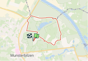
Randonnée Marche de 6,1 km à découvrir à Flandre, Limbourg, Bilzen. Cette randonnée est proposée par Benjamin27.
Description
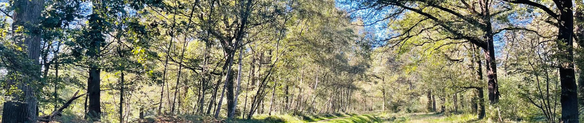
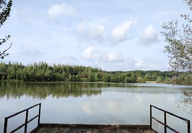
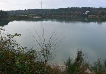
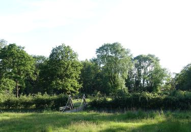
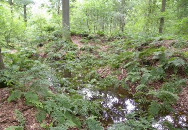
Tantôt le long d’un ruisseau, tantôt enfoncé au plus profond d’un bois, cette promenade isolée de tout est parfaite pour les personnes qui ont besoin de se retrouver et de profiter de la quiétude que la nature peut nous offrir.
👣 Distance : 6,1km - balisage triangle rouge.
🗺️ Carte / Fichier GPX en bio.
📍Départ : Parking sur Leroyplein à Munsterbilzen.
🚂 Gare de Bilzen 🚍DE LIJN 10 « Munsterbilzen - Centrum ».
Localisation
Commentaires
Randonnées à proximité
![Randonnée Marche Zutendaal - Promenade de Papendaalheide - Photo](https://media.geolcdn.com/t/375/260/4e56217a-c7d6-4b98-8c3a-5cd7f84ac60f.jpg&format=jpg&maxdim=2)
![Marche Marche](https://static1.geolcdn.com/sitytour/trail-icons/101.png)
Marche
![](/images/other/stat-length.png)
![](https://static1.geolcdn.com/siteimages/upload/files/16400158638029165_repeat_loop_refresh_sync_direction_icon.png)
![Randonnée A pied Zutendaal - Papendaalheide Groene rechthoek - Photo](https://media.geolcdn.com/t/375/260/61aba794-7888-4dc3-bb68-e186310dacfe.jpeg&format=jpg&maxdim=2)
![A pied A pied](https://static1.geolcdn.com/sitytour/trail-icons/100.png)
A pied
![](/images/other/stat-length.png)
![](https://static1.geolcdn.com/siteimages/upload/files/16400158638029165_repeat_loop_refresh_sync_direction_icon.png)
![Randonnée A pied Zutendaal - Lieteberg - Papendaalheide Rode driehoek - Photo](https://media.geolcdn.com/t/375/260/4351c275-94e5-4a21-8486-701fab6129e8.jpeg&format=jpg&maxdim=2)
![A pied A pied](https://static1.geolcdn.com/sitytour/trail-icons/100.png)
A pied
![](/images/other/stat-length.png)
![](https://static1.geolcdn.com/siteimages/upload/files/16400158638029165_repeat_loop_refresh_sync_direction_icon.png)
![Randonnée A pied Bilzen - Jonckholt Groene rechthoek - Photo](https://media.geolcdn.com/t/375/260/aa80814a-0379-40da-a67c-2dffd963d95b.jpeg&format=jpg&maxdim=2)
![A pied A pied](https://static1.geolcdn.com/sitytour/trail-icons/100.png)
A pied
![](/images/other/stat-length.png)
![](https://static1.geolcdn.com/siteimages/upload/files/16400158638029165_repeat_loop_refresh_sync_direction_icon.png)
![Randonnée A pied Bilzen - Jonckholt Blauwe ruit - Photo](https://media.geolcdn.com/t/375/260/aa80814a-0379-40da-a67c-2dffd963d95b.jpeg&format=jpg&maxdim=2)
![A pied A pied](https://static1.geolcdn.com/sitytour/trail-icons/100.png)
A pied
![](/images/other/stat-length.png)
![](https://static1.geolcdn.com/siteimages/upload/files/16400158638029165_repeat_loop_refresh_sync_direction_icon.png)
![Randonnée A pied Bilzen - Hoefaert Rode driehoek - Photo](https://media.geolcdn.com/t/375/260/5b2ce394-fffe-4e26-87f6-f3ba328634d3.jpeg&format=jpg&maxdim=2)
![A pied A pied](https://static1.geolcdn.com/sitytour/trail-icons/100.png)
A pied
![](/images/other/stat-length.png)
![](https://static1.geolcdn.com/siteimages/upload/files/16400158638029165_repeat_loop_refresh_sync_direction_icon.png)
![Randonnée A pied Zutendaal - Papendaalheide - Sledderlo Blauwe ruit - Photo](https://media.geolcdn.com/t/375/260/61aba794-7888-4dc3-bb68-e186310dacfe.jpeg&format=jpg&maxdim=2)
![A pied A pied](https://static1.geolcdn.com/sitytour/trail-icons/100.png)
A pied
![](/images/other/stat-length.png)
![](https://static1.geolcdn.com/siteimages/upload/files/16400158638029165_repeat_loop_refresh_sync_direction_icon.png)
![Randonnée A pied Bilzen - Munsterbos Blauwe ruit - Photo](https://media.geolcdn.com/t/375/260/45e22196-37f0-42d6-bd65-1f6a44ce93fe.jpeg&format=jpg&maxdim=2)
![A pied A pied](https://static1.geolcdn.com/sitytour/trail-icons/100.png)
A pied
![](/images/other/stat-length.png)
![](https://static1.geolcdn.com/siteimages/upload/files/16400158638029165_repeat_loop_refresh_sync_direction_icon.png)
![Randonnée A pied Bilzen - Munsterbos Rode driehoek - Photo](https://media.geolcdn.com/t/375/260/45e22196-37f0-42d6-bd65-1f6a44ce93fe.jpeg&format=jpg&maxdim=2)
![A pied A pied](https://static1.geolcdn.com/sitytour/trail-icons/100.png)
A pied
![](/images/other/stat-length.png)
![](https://static1.geolcdn.com/siteimages/upload/files/16400158638029165_repeat_loop_refresh_sync_direction_icon.png)