Randonnée Randonnée équestre Doische - sur les traces préhistoriques (5 pdl) - Photo

sur les traces préhistoriques (5 pdl)

 annecastelain
annecastelain

Utilisateur

© OpenStreetMap contributors
Longueur
Longueur
15,2 km
Altitude max
Altitude max
260 m
Dénivelé positif
Dénivelé positif
303 m
Km-Effort
Km-Effort  
19,1 km
Altitude min
Altitude min
122 m
Dénivelé négatif
Dénivelé négatif
271 m
Boucle
Boucle
Non
Date de création :
2023-09-23 12:47:47.146
Dernière modification :
2023-09-27 15:32:44.66

(0 Avis)

Randonnée équestre
Randonnée équestre
2h31
Difficulté : Facile

Scannez ce code QR pour ouvrir la randonnée dans l'application SityTrail

Application GPS de randonnée GRATUITE

Logo SityTrail SityTrail

IGN / Instituts géographiques

Télécharger SityTrail sur l'App Store Télécharger SityTrail sur Google Play

Logo SityTrail SityTrail World

Le monde est à vous

Télécharger SityTrail sur l'App Store Télécharger SityTrail sur Google Play Télécharger SityTrail sur Huawei AppGallery

À propos

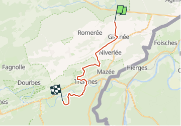
Randonnée Randonnée équestre de 15,2 km à découvrir à Wallonie, Namur, Doische. Cette randonnée est proposée par annecastelain.

Description

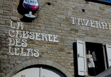
ravel 156,les tourneux-5680 doische-> chemin du bois, 5670 vierves sur viroin

Profil altimétrique

Points d'intérêt

Point d'intérêt Doische - la ferme du crestia - Photo
annecastelain
Point d'intérêt Viroinval - ferme chateau de dourbes - Photo
annecastelain
Point d'intérêt Viroinval - gîte le ramponneau - Photo
annecastelain
Point d'intérêt Viroinval - gîte le roi cerf - Photo
annecastelain
Point d'intérêt Viroinval - au coeur de la nature(booking) - Photo
annecastelain
Point d'intérêt Viroinval - chalet n°5(booking) - Photo
annecastelain
Point d'intérêt Viroinval - les gabelous(booking) - Photo
annecastelain
Point d'intérêt Doische - chalet pimpernel - Photo
annecastelain

Localisation

Pays :
Belgique
Région :
Wallonie
Département/Province :
Namur
Commune :
Doische
Localité :
Unknown
Départ:(UTM)
622094 ; 5556163 (31U) N.

Randonnées à proximité

Randonnée Marche Doische - RB-Na-11_Soulme - Photo
Marche
PRO

Marche

Moyen
(4)
Doische, Wallonie, Namur, Belgique
25 km | 31 km-effort
6h 40min
Oui
Randonnée Marche Viroinval - Mazée, sur le sentier des Douaniers - Photo
Marche
GUIDE
Desrumaux

Marche

Très facile
(1)
Viroinval, Wallonie, Namur, Belgique
7,6 km | 10,5 km-effort
4h 2min
Oui
Randonnée Marche Doische - RB-Na-11_Soulme_via-racc - Photo
Marche
PRO

Marche

Moyen
(5)
Doische, Wallonie, Namur, Belgique
19,7 km | 25 km-effort
5h 22min
Oui
Randonnée Marche Doische - De Gochenee vers Soulme par la vallee de l'Ermeton - Photo
Marche
GUIDE
Desrumaux

Marche

Moyen
(1)
Doische, Wallonie, Namur, Belgique
18,5 km | 24 km-effort
4h 40min
Oui
Randonnée Marche Doische - Promenade à Vodelée - Photo
Marche
GUIDE
Desrumaux

Marche

Facile
(1)
Doische, Wallonie, Namur, Belgique
9,3 km | 11,4 km-effort
2h 15min
Oui
Randonnée Marche Doische - Balade de Doische à Foisches - Photo
Marche
GUIDE
Desrumaux

Marche

Difficile
Doische, Wallonie, Namur, Belgique
9,9 km | 12,5 km-effort
2h 49min
Oui
Randonnée Marche Doische - De Vaucelles à Hierges par la montagne de le carrière - Photo
Marche
GUIDE
Desrumaux

Marche

Moyen
(1)
Doische, Wallonie, Namur, Belgique
6,7 km | 8,7 km-effort
1h 58min
Oui
Randonnée Marche Doische - Promenade de la Bonne-Fontaine   - Photo
Marche
GUIDE+

Marche

Moyen
(3)
Doische, Wallonie, Namur, Belgique
7,3 km | 9,4 km-effort
2h 7min
Oui
Randonnée Marche Doische - De Gochenée à Vodelée par la vallée de l'Hermeton - Photo
Marche
GUIDE
Desrumaux

Marche

Difficile
Doische, Wallonie, Namur, Belgique
10,7 km | 12,9 km-effort
3h 46min
Oui


Fermer
Mes abonnements