![](/images/other/stat-length.png)
![Randonnée Marche Ganzeville - Au coeur des 2 vallées - Photo](https://media.geolcdn.com/t/1900/400/ext.pjpeg?maxdim=2&url=https%3A%2F%2Fstatic1.geolcdn.com%2Fsiteimages%2Fupload%2Ffiles%2F1553511878bg_sport_marche.png)
Au coeur des 2 vallées
Jamyfredo
Utilisateur
![Longueur](/images/other/stat-length.png)
Longueur
11,2 km
![Altitude max](https://static1.geolcdn.com/siteimages/upload/files/1508320355ic_sort_altitude_max_24dp.png)
Altitude max
112 m
![Dénivelé positif](https://static1.geolcdn.com/siteimages/upload/files/1508320355ic_sort_den_pos_24dp.png)
Dénivelé positif
196 m
![Km-Effort](/images/other/stat-length.png)
Km-Effort
13,8 km
![Altitude min](https://static1.geolcdn.com/siteimages/upload/files/1508320355ic_sort_altitude_min_24dp.png)
Altitude min
11 m
![Dénivelé négatif](https://static1.geolcdn.com/siteimages/upload/files/1508320355ic_sort_den_neg_24dp.png)
Dénivelé négatif
197 m
![Boucle](https://static1.geolcdn.com/siteimages/upload/files/16400158638029165_repeat_loop_refresh_sync_direction_icon.png)
Boucle
Oui
Date de création :
2023-09-18 16:16:07.366
Dernière modification :
2023-09-18 16:19:05.305
![Marche](https://static1.geolcdn.com/sitytour/trail-icons/101.png)
2h25
Difficulté : Facile
![Scannez ce code QR pour ouvrir la randonnée dans l'application SityTrail](https://capi.geolives.com/qq0zvz2zws4bq2lad0pu/sitytour/trails/3810856/qr.png?size=200)
Application GPS de randonnée GRATUITE
À propos
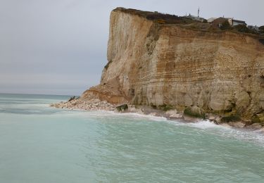
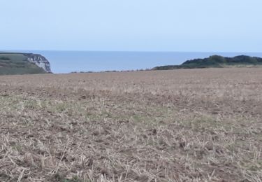
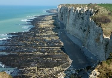
Randonnée Marche de 11,2 km à découvrir à Normandie, Seine-Maritime, Ganzeville. Cette randonnée est proposée par Jamyfredo.
Description
Diversités de paysages et d'atmosphères qu'offrent les proches alentours de Fécamp en passant dans la vallée de Ganzeville et de Valmont
Localisation
Pays :
France
Région :
Normandie
Département/Province :
Seine-Maritime
Commune :
Ganzeville
Localité :
Unknown
Départ:(Dec)
Départ:(UTM)
313494 ; 5512203 (31U) N.
Commentaires
Randonnées à proximité
![Randonnée Marche Fécamp - Nid Verdier - Val aux lièvres - Photo](https://media.geolcdn.com/t/375/260/ext.jpg?maxdim=2&url=https%3A%2F%2Fstatic1.geolcdn.com%2Fsiteimages%2Fupload%2Ffiles%2F1553511878bg_sport_marche.png)
![Marche Marche](https://static1.geolcdn.com/sitytour/trail-icons/101.png)
Nid Verdier - Val aux lièvres
Marche
Moyen
(1)
Fécamp,
Normandie,
Seine-Maritime,
France
![](/images/other/stat-length.png)
6,3 km | 7,8 km-effort
1h 42min
![](https://static1.geolcdn.com/siteimages/upload/files/16400158638029165_repeat_loop_refresh_sync_direction_icon.png)
Oui
![Randonnée Marche Fécamp - fecamp - Photo](https://media.geolcdn.com/t/375/260/d0e6349d-5429-4f08-9deb-c4d6ba33fa26.jpg&format=jpg&maxdim=2)
![Marche Marche](https://static1.geolcdn.com/sitytour/trail-icons/101.png)
![Randonnée Marche Fécamp - la capelle a Fécamp - Photo](https://media.geolcdn.com/t/375/260/1b7b4132-ad2b-4597-be7b-ed63911e98b5.jpg&format=jpg&maxdim=2)
![Marche Marche](https://static1.geolcdn.com/sitytour/trail-icons/101.png)
la capelle a Fécamp
Marche
Facile
Fécamp,
Normandie,
Seine-Maritime,
France
![](/images/other/stat-length.png)
8,5 km | 10,6 km-effort
1h 57min
![](https://static1.geolcdn.com/siteimages/upload/files/16400158638029165_repeat_loop_refresh_sync_direction_icon.png)
Non
![Randonnée Autre activité Saint-Léonard - grainval -yport puis tour dans yport vers casino - Photo](https://media.geolcdn.com/t/375/260/ext.jpg?maxdim=2&url=https%3A%2F%2Fservices.sitytrail.com%2FGeolivesWS%2FDownloadMedia.ashx%3FTrailID%3D1028875%26Media%3Dfix__20180826113810.jpg)
![Autre activité Autre activité](https://static1.geolcdn.com/sitytour/trail-icons/900.png)
grainval -yport puis tour dans yport vers casino
Autre activité
Très facile
Saint-Léonard,
Normandie,
Seine-Maritime,
France
![](/images/other/stat-length.png)
5,2 km | 6,8 km-effort
49min
![](https://static1.geolcdn.com/siteimages/upload/files/16400158638029165_repeat_loop_refresh_sync_direction_icon.png)
Non
![Randonnée Moteur Fécamp - Fécamp-Rouen 15.10.17 - Photo](https://media.geolcdn.com/t/375/260/ext.jpg?maxdim=2&url=https%3A%2F%2Fservices.sitytrail.com%2FGeolivesWS%2FDownloadMedia.ashx%3FTrailID%3D849051%26Media%3Dfix__20171015182604.jpg)
![Moteur Moteur](https://static1.geolcdn.com/sitytour/trail-icons/400.png)
Fécamp-Rouen 15.10.17
Moteur
Très facile
Fécamp,
Normandie,
Seine-Maritime,
France
![](/images/other/stat-length.png)
205 km | 234 km-effort
7h 4min
![](https://static1.geolcdn.com/siteimages/upload/files/16400158638029165_repeat_loop_refresh_sync_direction_icon.png)
Non
![Randonnée Marche Fécamp - Étretat jour 2 - Photo](https://media.geolcdn.com/t/375/260/ext.jpg?maxdim=2&url=https%3A%2F%2Fservices.sitytrail.com%2FGeolivesWS%2FDownloadMedia.ashx%3FTrailID%3D721389%26Media%3Dfix__20170326152128.jpg)
![Marche Marche](https://static1.geolcdn.com/sitytour/trail-icons/101.png)
Étretat jour 2
Marche
Très facile
Fécamp,
Normandie,
Seine-Maritime,
France
![](/images/other/stat-length.png)
17,6 km | 23 km-effort
7h 51min
![](https://static1.geolcdn.com/siteimages/upload/files/16400158638029165_repeat_loop_refresh_sync_direction_icon.png)
Non
![Randonnée Marche Fécamp - Fécamp La cote de la Vierge - Photo](https://media.geolcdn.com/t/375/260/ext.jpg?maxdim=2&url=https%3A%2F%2Fstatic1.geolcdn.com%2Fsiteimages%2Fupload%2Ffiles%2F1553511878bg_sport_marche.png)
![Marche Marche](https://static1.geolcdn.com/sitytour/trail-icons/101.png)
Fécamp La cote de la Vierge
Marche
Difficile
(1)
Fécamp,
Normandie,
Seine-Maritime,
France
![](/images/other/stat-length.png)
12,9 km | 15,2 km-effort
3h 27min
![](https://static1.geolcdn.com/siteimages/upload/files/16400158638029165_repeat_loop_refresh_sync_direction_icon.png)
Oui
![Randonnée Marche Saint-Léonard - Fécamp Sur les pas des ramendeuses - Photo](https://media.geolcdn.com/t/375/260/ext.jpg?maxdim=2&url=https%3A%2F%2Fstatic1.geolcdn.com%2Fsiteimages%2Fupload%2Ffiles%2F1553511878bg_sport_marche.png)
![Marche Marche](https://static1.geolcdn.com/sitytour/trail-icons/101.png)
Fécamp Sur les pas des ramendeuses
Marche
Difficile
Saint-Léonard,
Normandie,
Seine-Maritime,
France
![](/images/other/stat-length.png)
13,6 km | 17,2 km-effort
3h 53min
![](https://static1.geolcdn.com/siteimages/upload/files/16400158638029165_repeat_loop_refresh_sync_direction_icon.png)
Oui
![Randonnée Marche Bec-de-Mortagne - bec de mortagne - Photo](https://media.geolcdn.com/t/375/260/ext.jpg?maxdim=2&url=https%3A%2F%2Fstatic1.geolcdn.com%2Fsiteimages%2Fupload%2Ffiles%2F1553511878bg_sport_marche.png)
![Marche Marche](https://static1.geolcdn.com/sitytour/trail-icons/101.png)
bec de mortagne
Marche
Moyen
Bec-de-Mortagne,
Normandie,
Seine-Maritime,
France
![](/images/other/stat-length.png)
12,7 km | 14,8 km-effort
2h 52min
![](https://static1.geolcdn.com/siteimages/upload/files/16400158638029165_repeat_loop_refresh_sync_direction_icon.png)
Oui