![](/images/other/stat-length.png)
![Randonnée Marche Bastogne - Trail du Souvenir - Bastogne - 20 km - Photo](https://media.geolcdn.com/t/1900/400/ext.pjpeg?maxdim=2&url=https%3A%2F%2Fstatic1.geolcdn.com%2Fsiteimages%2Fupload%2Ffiles%2F1553511878bg_sport_marche.png)
Trail du Souvenir - Bastogne - 20 km
m.devil
Utilisateur
![Longueur](/images/other/stat-length.png)
Longueur
20 km
![Altitude max](https://static1.geolcdn.com/siteimages/upload/files/1508320355ic_sort_altitude_max_24dp.png)
Altitude max
557 m
![Dénivelé positif](https://static1.geolcdn.com/siteimages/upload/files/1508320355ic_sort_den_pos_24dp.png)
Dénivelé positif
289 m
![Km-Effort](/images/other/stat-length.png)
Km-Effort
24 km
![Altitude min](https://static1.geolcdn.com/siteimages/upload/files/1508320355ic_sort_altitude_min_24dp.png)
Altitude min
489 m
![Dénivelé négatif](https://static1.geolcdn.com/siteimages/upload/files/1508320355ic_sort_den_neg_24dp.png)
Dénivelé négatif
312 m
![Boucle](https://static1.geolcdn.com/siteimages/upload/files/16400158638029165_repeat_loop_refresh_sync_direction_icon.png)
Boucle
Non
Date de création :
2023-09-16 08:34:48.537
Dernière modification :
2023-09-16 08:58:48.21
![Marche](https://static1.geolcdn.com/sitytour/trail-icons/101.png)
5h30
Difficulté : Difficile
![Scannez ce code QR pour ouvrir la randonnée dans l'application SityTrail](https://capi.geolives.com/qq0zvz2zws4bq2lad0pu/sitytour/trails/3807994/qr.png?size=200)
Application GPS de randonnée GRATUITE
À propos
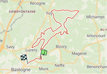
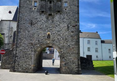
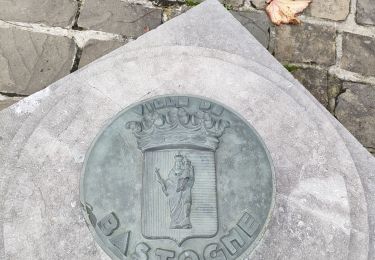
Randonnée Marche de 20 km à découvrir à Wallonie, Luxembourg, Bastogne. Cette randonnée est proposée par m.devil.
Description
Randonnée tracée à partir du parking du Mardasson et retour au centre sportif Porte de Trêves. La marche organisée le même jour (21 km) part et revient au Centre Sportif par le même chemin.
Localisation
Pays :
Belgique
Région :
Wallonie
Département/Province :
Luxembourg
Commune :
Bastogne
Localité :
Unknown
Départ:(Dec)
Départ:(UTM)
696294 ; 5543351 (31U) N.
Commentaires
Randonnées à proximité
![Randonnée Marche Bastogne - RF-Lu-07 - Entre prairies aux bisons et](https://media.geolcdn.com/t/375/260/ext.jpg?maxdim=2&url=https%3A%2F%2Fstatic1.geolcdn.com%2Fsiteimages%2Fupload%2Ffiles%2F1553511878bg_sport_marche.png)
![Marche Marche](https://static1.geolcdn.com/sitytour/trail-icons/101.png)
RF-Lu-07 - Entre prairies aux bisons et "chemin des Pèlerins" : Recogne
Marche
Très facile
(2)
Bastogne,
Wallonie,
Luxembourg,
Belgique
![](/images/other/stat-length.png)
11,7 km | 13,9 km-effort
3h 4min
![](https://static1.geolcdn.com/siteimages/upload/files/16400158638029165_repeat_loop_refresh_sync_direction_icon.png)
Oui
![Randonnée A pied Bastogne - Promenade de Sans-souci - Photo](https://media.geolcdn.com/t/375/260/7d0be711-2b6c-4626-95af-6f44538f00ad.jpeg&format=jpg&maxdim=2)
![A pied A pied](https://static1.geolcdn.com/sitytour/trail-icons/100.png)
Promenade de Sans-souci
A pied
Facile
Bastogne,
Wallonie,
Luxembourg,
Belgique
![](/images/other/stat-length.png)
10 km | 11,7 km-effort
2h 40min
![](https://static1.geolcdn.com/siteimages/upload/files/16400158638029165_repeat_loop_refresh_sync_direction_icon.png)
Oui
![Randonnée A pied Bastogne - Promenade du chemin des Pélerins - Photo](https://media.geolcdn.com/t/375/260/2e9e462c-7e4b-4e66-b4b8-7cb92983120d.jpeg&format=jpg&maxdim=2)
![A pied A pied](https://static1.geolcdn.com/sitytour/trail-icons/100.png)
Promenade du chemin des Pélerins
A pied
Facile
(1)
Bastogne,
Wallonie,
Luxembourg,
Belgique
![](/images/other/stat-length.png)
7,9 km | 9,6 km-effort
2h 10min
![](https://static1.geolcdn.com/siteimages/upload/files/16400158638029165_repeat_loop_refresh_sync_direction_icon.png)
Oui
![Randonnée Marche Bastogne - Bastogne - MESA 2021 - Photo](https://media.geolcdn.com/t/375/260/7f6f41fe-3993-4cdf-90c5-d536a8644baf.jpg&format=jpg&maxdim=2)
![Marche Marche](https://static1.geolcdn.com/sitytour/trail-icons/101.png)
Bastogne - MESA 2021
Marche
Facile
Bastogne,
Wallonie,
Luxembourg,
Belgique
![](/images/other/stat-length.png)
16,3 km | 19,6 km-effort
3h 32min
![](https://static1.geolcdn.com/siteimages/upload/files/16400158638029165_repeat_loop_refresh_sync_direction_icon.png)
Oui
![Randonnée Marche Bastogne - Bastogne Mesa 280624 - Photo](https://media.geolcdn.com/t/375/260/21892c2e-ecf3-4b1b-9fd3-65a01c582f5a.jpg&format=jpg&maxdim=2)
![Marche Marche](https://static1.geolcdn.com/sitytour/trail-icons/101.png)
Bastogne Mesa 280624
Marche
Difficile
Bastogne,
Wallonie,
Luxembourg,
Belgique
![](/images/other/stat-length.png)
31 km | 38 km-effort
7h 30min
![](https://static1.geolcdn.com/siteimages/upload/files/16400158638029165_repeat_loop_refresh_sync_direction_icon.png)
Non
![Randonnée Marche Bastogne - route gen. patton in bastogne - Photo](https://media.geolcdn.com/t/375/260/08ba5daf-d3ce-4b66-8cef-496ca4dcfc13.jpg&format=jpg&maxdim=2)
![Marche Marche](https://static1.geolcdn.com/sitytour/trail-icons/101.png)
route gen. patton in bastogne
Marche
Facile
Bastogne,
Wallonie,
Luxembourg,
Belgique
![](/images/other/stat-length.png)
4,7 km | 5,3 km-effort
1h 33min
![](https://static1.geolcdn.com/siteimages/upload/files/16400158638029165_repeat_loop_refresh_sync_direction_icon.png)
Oui
![Randonnée A pied Bastogne - Promenade du Bois de la Paix - Photo](https://media.geolcdn.com/t/375/260/ext.jpg?maxdim=2&url=https%3A%2F%2Fpivotmedia.tourismewallonie.be%2FOTH-A0-005K-152P%2FOTH-A0-005K-152P.jpg)
![A pied A pied](https://static1.geolcdn.com/sitytour/trail-icons/100.png)
Promenade du Bois de la Paix
A pied
Facile
Bastogne,
Wallonie,
Luxembourg,
Belgique
![](/images/other/stat-length.png)
10,1 km | 11,9 km-effort
2h 41min
![](https://static1.geolcdn.com/siteimages/upload/files/16400158638029165_repeat_loop_refresh_sync_direction_icon.png)
Oui
![Randonnée A pied Bastogne - Promenade du chemin des Pélerins - Photo](https://media.geolcdn.com/t/375/260/ext.jpg?maxdim=2&url=https%3A%2F%2Fpivotmedia.tourismewallonie.be%2FOTH-A0-005K-14UP%2FOTH-A0-005K-14UP.jpg)
![A pied A pied](https://static1.geolcdn.com/sitytour/trail-icons/100.png)
Promenade du chemin des Pélerins
A pied
Facile
Bastogne,
Wallonie,
Luxembourg,
Belgique
![](/images/other/stat-length.png)
8 km | 9,7 km-effort
2h 12min
![](https://static1.geolcdn.com/siteimages/upload/files/16400158638029165_repeat_loop_refresh_sync_direction_icon.png)
Oui
![Randonnée A pied Bastogne - Promenade de Sans-Souci - Photo](https://media.geolcdn.com/t/375/260/ext.jpg?maxdim=2&url=https%3A%2F%2Fpivotmedia.tourismewallonie.be%2FOTH-A0-005K-14JQ%2FOTH-A0-005K-14JQ.jpg)
![A pied A pied](https://static1.geolcdn.com/sitytour/trail-icons/100.png)
Promenade de Sans-Souci
A pied
Facile
Bastogne,
Wallonie,
Luxembourg,
Belgique
![](/images/other/stat-length.png)
10 km | 11,7 km-effort
2h 39min
![](https://static1.geolcdn.com/siteimages/upload/files/16400158638029165_repeat_loop_refresh_sync_direction_icon.png)
Oui