![](/images/other/stat-length.png)
![Randonnée Cyclotourisme Givet - Route Verte EV03 Givet - Charleville-Mézières - Photo](https://media.geolcdn.com/t/1900/400/c0c65395-ae86-41ee-857d-b0ebbeff24ed.png&format=pjpeg&maxdim=2)
Route Verte EV03 Givet - Charleville-Mézières
m.devil
Utilisateur
![Longueur](/images/other/stat-length.png)
Longueur
87 km
![Altitude max](https://static1.geolcdn.com/siteimages/upload/files/1508320355ic_sort_altitude_max_24dp.png)
Altitude max
181 m
![Dénivelé positif](https://static1.geolcdn.com/siteimages/upload/files/1508320355ic_sort_den_pos_24dp.png)
Dénivelé positif
1055 m
![Km-Effort](/images/other/stat-length.png)
Km-Effort
101 km
![Altitude min](https://static1.geolcdn.com/siteimages/upload/files/1508320355ic_sort_altitude_min_24dp.png)
Altitude min
91 m
![Dénivelé négatif](https://static1.geolcdn.com/siteimages/upload/files/1508320355ic_sort_den_neg_24dp.png)
Dénivelé négatif
1000 m
![Boucle](https://static1.geolcdn.com/siteimages/upload/files/16400158638029165_repeat_loop_refresh_sync_direction_icon.png)
Boucle
Non
Date de création :
2023-09-08 06:01:41.68
Dernière modification :
2023-09-16 09:58:24.605
![Cyclotourisme](https://static1.geolcdn.com/sitytour/trail-icons/204.png)
--
Difficulté : Très difficile
![Scannez ce code QR pour ouvrir la randonnée dans l'application SityTrail](https://capi.geolives.com/qq0zvz2zws4bq2lad0pu/sitytour/trails/3799125/qr.png?size=200)
Application GPS de randonnée GRATUITE
À propos
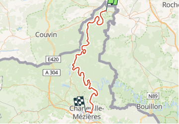
Randonnée Cyclotourisme de 87 km à découvrir à Grand Est, Ardennes, Givet. Cette randonnée est proposée par m.devil.
Description
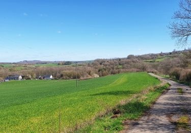
Route cyclable de grande qualité.
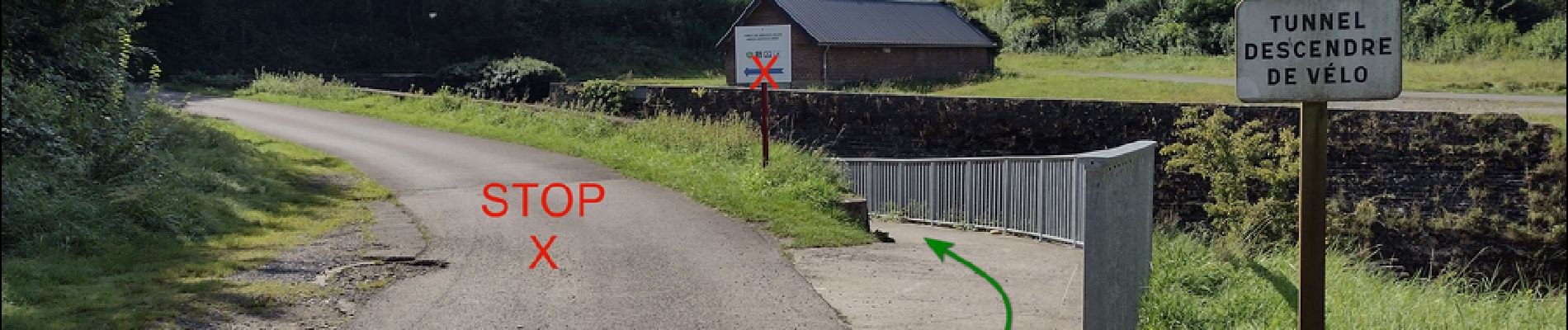
Attention à ne pas rater le tunnel du chemin de fer à l'entré de Revin!
NE PAS suivre la flèche bleue, mais bien le panneau
"Tunnel - Descendre de vélo".
Cf photo
Arrivée Place du Théâtre - restaurant / chambres d'hôtes "La papillote"
Localisation
Pays :
France
Région :
Grand Est
Département/Province :
Ardennes
Commune :
Givet
Localité :
Unknown
Départ:(Dec)
Départ:(UTM)
630583 ; 5555226 (31U) N.
Commentaires
Randonnées à proximité
![Randonnée Marche Givet - Balade à Givet - Photo](https://media.geolcdn.com/t/375/260/ext.jpg?maxdim=2&url=https%3A%2F%2Fservices.sitytrail.com%2FGeolivesWS%2FDownloadMedia.ashx%3FTrailID%3D110616%26Media%3D6179_5.jpg)
![Marche Marche](https://static1.geolcdn.com/sitytour/trail-icons/101.png)
![Randonnée Marche Givet - Promenade sur les remparts du Mont d'Haurs - Photo](https://media.geolcdn.com/t/375/260/ext.jpg?maxdim=2&url=https%3A%2F%2Fservices.sitytrail.com%2FGeolivesWS%2FDownloadMedia.ashx%3FTrailID%3D108905%26Media%3D2570_6.jpg)
![Marche Marche](https://static1.geolcdn.com/sitytour/trail-icons/101.png)
Promenade sur les remparts du Mont d'Haurs
Marche
Moyen
(3)
Givet,
Grand Est,
Ardennes,
France
![](/images/other/stat-length.png)
5,1 km | 6,7 km-effort
2h 0min
![](https://static1.geolcdn.com/siteimages/upload/files/16400158638029165_repeat_loop_refresh_sync_direction_icon.png)
Oui
![Randonnée Marche Hastière - Hastiere, Entre mont et vallée - Photo](https://media.geolcdn.com/t/375/260/068d5622-8276-4255-80ea-e863a3df9f37.jpg&format=jpg&maxdim=2)
![Marche Marche](https://static1.geolcdn.com/sitytour/trail-icons/101.png)
Hastiere, Entre mont et vallée
Marche
Moyen
(2)
Hastière,
Wallonie,
Namur,
Belgique
![](/images/other/stat-length.png)
11,2 km | 14,3 km-effort
2h 5min
![](https://static1.geolcdn.com/siteimages/upload/files/16400158638029165_repeat_loop_refresh_sync_direction_icon.png)
Oui
![Randonnée Marche Rancennes - De Rancennes à Charnois par les Rochers du Petit Chooz - Photo](https://media.geolcdn.com/t/375/260/ext.jpg?maxdim=2&url=https%3A%2F%2Fstatic1.geolcdn.com%2Fsiteimages%2Fupload%2Ffiles%2F1553511878bg_sport_marche.png)
![Marche Marche](https://static1.geolcdn.com/sitytour/trail-icons/101.png)
De Rancennes à Charnois par les Rochers du Petit Chooz
Marche
Facile
(1)
Rancennes,
Grand Est,
Ardennes,
France
![](/images/other/stat-length.png)
10,6 km | 14,6 km-effort
2h 30min
![](https://static1.geolcdn.com/siteimages/upload/files/16400158638029165_repeat_loop_refresh_sync_direction_icon.png)
Oui
![Randonnée Marche Beauraing - Balade de Dion à Winenne - Beauraing - Photo](https://media.geolcdn.com/t/375/260/5c1dc6e2-7e96-43cd-a912-ceabbaabe8bc.jpeg&format=jpg&maxdim=2)
![Marche Marche](https://static1.geolcdn.com/sitytour/trail-icons/101.png)
Balade de Dion à Winenne - Beauraing
Marche
Moyen
(2)
Beauraing,
Wallonie,
Namur,
Belgique
![](/images/other/stat-length.png)
6,5 km | 8,5 km-effort
1h 55min
![](https://static1.geolcdn.com/siteimages/upload/files/16400158638029165_repeat_loop_refresh_sync_direction_icon.png)
Oui
![Randonnée Marche Beauraing - Balade à Winenne - Beauraing - Photo](https://media.geolcdn.com/t/375/260/8bfd43ea-288d-45ae-81cb-56021fe3f6e3.jpeg&format=jpg&maxdim=2)
![Marche Marche](https://static1.geolcdn.com/sitytour/trail-icons/101.png)
Balade à Winenne - Beauraing
Marche
Difficile
Beauraing,
Wallonie,
Namur,
Belgique
![](/images/other/stat-length.png)
11,7 km | 14,7 km-effort
3h 20min
![](https://static1.geolcdn.com/siteimages/upload/files/16400158638029165_repeat_loop_refresh_sync_direction_icon.png)
Oui
![Randonnée Marche Houyet - Marche Adeps à Mesnil-Saint-Blaise - Photo](https://media.geolcdn.com/t/375/260/6e90d8be-93ef-4b26-838b-b9d31637f07d.jpeg&format=jpg&maxdim=2)
![Marche Marche](https://static1.geolcdn.com/sitytour/trail-icons/101.png)
Marche Adeps à Mesnil-Saint-Blaise
Marche
Moyen
Houyet,
Wallonie,
Namur,
Belgique
![](/images/other/stat-length.png)
9,8 km | 11,4 km-effort
2h 35min
![](https://static1.geolcdn.com/siteimages/upload/files/16400158638029165_repeat_loop_refresh_sync_direction_icon.png)
Oui
![Randonnée Marche Hastière - Promenade 10 - Le Sicou (O.T. Hastière) - Photo](https://media.geolcdn.com/t/375/260/ext.jpg?maxdim=2&url=https%3A%2F%2Fstatic1.geolcdn.com%2Fsiteimages%2Fupload%2Ffiles%2F1553511878bg_sport_marche.png)
![Marche Marche](https://static1.geolcdn.com/sitytour/trail-icons/101.png)
Promenade 10 - Le Sicou (O.T. Hastière)
Marche
Facile
(2)
Hastière,
Wallonie,
Namur,
Belgique
![](/images/other/stat-length.png)
6,9 km | 9,2 km-effort
1h 57min
![](https://static1.geolcdn.com/siteimages/upload/files/16400158638029165_repeat_loop_refresh_sync_direction_icon.png)
Oui
![Randonnée Marche Beauraing - WINENNE ( BEAURAING) _ Marche Fédérales _ NA _ 8/07/2023 - Photo](https://media.geolcdn.com/t/375/260/eb96292b-4717-48a0-89be-098a3bf2f9f3.jpg&format=jpg&maxdim=2)
![Marche Marche](https://static1.geolcdn.com/sitytour/trail-icons/101.png)
WINENNE ( BEAURAING) _ Marche Fédérales _ NA _ 8/07/2023
Marche
Difficile
Beauraing,
Wallonie,
Namur,
Belgique
![](/images/other/stat-length.png)
20 km | 26 km-effort
4h 45min
![](https://static1.geolcdn.com/siteimages/upload/files/16400158638029165_repeat_loop_refresh_sync_direction_icon.png)
Oui