![](/images/other/stat-length.png)
![Randonnée Marche Vinadio - Bagni Vinadio J1 à Refuge Mogliorero par P26 - Photo](https://media.geolcdn.com/t/1900/400/ext.pjpeg?maxdim=2&url=https%3A%2F%2Fstatic1.geolcdn.com%2Fsiteimages%2Fupload%2Ffiles%2F1553511878bg_sport_marche.png)
Bagni Vinadio J1 à Refuge Mogliorero par P26
MAD-CVW
Utilisateur
![Longueur](/images/other/stat-length.png)
![Altitude max](https://static1.geolcdn.com/siteimages/upload/files/1508320355ic_sort_altitude_max_24dp.png)
![Dénivelé positif](https://static1.geolcdn.com/siteimages/upload/files/1508320355ic_sort_den_pos_24dp.png)
![Km-Effort](/images/other/stat-length.png)
![Altitude min](https://static1.geolcdn.com/siteimages/upload/files/1508320355ic_sort_altitude_min_24dp.png)
![Dénivelé négatif](https://static1.geolcdn.com/siteimages/upload/files/1508320355ic_sort_den_neg_24dp.png)
![Boucle](https://static1.geolcdn.com/siteimages/upload/files/16400158638029165_repeat_loop_refresh_sync_direction_icon.png)
![Marche](https://static1.geolcdn.com/sitytour/trail-icons/101.png)
5h11
Difficulté : Très difficile
![Scannez ce code QR pour ouvrir la randonnée dans l'application SityTrail](https://capi.geolives.com/qq0zvz2zws4bq2lad0pu/sitytour/trails/3795159/qr.png?size=200)
Application GPS de randonnée GRATUITE
À propos
Randonnée Marche de 14,5 km à découvrir à Piémont, Coni, Vinadio. Cette randonnée est proposée par MAD-CVW.
Description
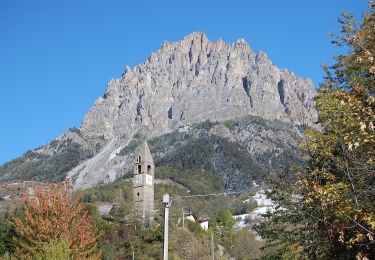
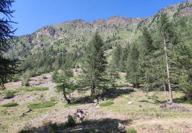
départ de Bagni en montant l'itinéraire P26 balisé rouge-blanc, a droite de l'église sur beau sentier prenant rapidement de l'altitude. passage dans le village de Besmorello aux maisons typiques, puis le sentier progresse par des prairies jusqu'au hameau de Luca a 1542m. Sculptures en tôle de Loulou.
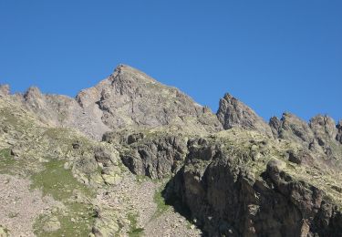
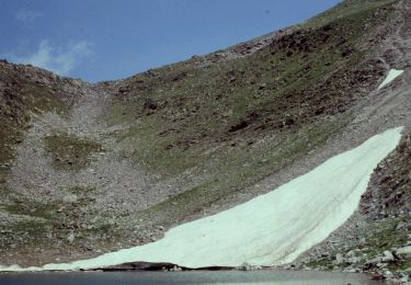
Prendre le chemin à gauche pour monter par la rive droite du torrent Ischiator et rejoindre le sentier vers le refuge en laissant le chemin carrossable sur la droite. Traverser un pont, le sentier monte rive gauche jusqu'à une très belle cascade a 1800m, puis monté agréable jusqu'au bas du refuge
Retour par même chemin avec variante par Strada rive gauche jusqu'à Besmorello, puis sentier descendant à Bagni.
Localisation
Commentaires
Randonnées à proximité
![Randonnée A pied Vinadio - Alte Valli - Tappa 02 - Photo](https://media.geolcdn.com/t/375/260/c740d10d-1035-4c17-b746-4abae2faca8a.jpeg&format=jpg&maxdim=2)
![A pied A pied](https://static1.geolcdn.com/sitytour/trail-icons/100.png)
A pied
![](/images/other/stat-length.png)
![](https://static1.geolcdn.com/siteimages/upload/files/16400158638029165_repeat_loop_refresh_sync_direction_icon.png)
![Randonnée A pied Vinadio - (SI E14) Vinadio Frazione Strepeis - Sambuco - Photo](https://media.geolcdn.com/t/375/260/ac5e8239-e7ed-43bc-86ad-324f2c2e7376.jpeg&format=jpg&maxdim=2)
![A pied A pied](https://static1.geolcdn.com/sitytour/trail-icons/100.png)
A pied
![](/images/other/stat-length.png)
![](https://static1.geolcdn.com/siteimages/upload/files/16400158638029165_repeat_loop_refresh_sync_direction_icon.png)
![Randonnée A pied Vinadio - San Bernolfo-Corborant - Photo](https://media.geolcdn.com/t/375/260/d482fac5-441b-457e-9b24-5a828305619b.jpeg&format=jpg&maxdim=2)
![A pied A pied](https://static1.geolcdn.com/sitytour/trail-icons/100.png)
A pied
![](/images/other/stat-length.png)
![](https://static1.geolcdn.com/siteimages/upload/files/16400158638029165_repeat_loop_refresh_sync_direction_icon.png)
![Randonnée Marche Vinadio - Étape 4 Refuge Alexandris Foche / Isola 2000 - Photo](https://media.geolcdn.com/t/375/260/859c6382-0d81-454d-80a8-0fe96066cf42.jpg&format=jpg&maxdim=2)
![Marche Marche](https://static1.geolcdn.com/sitytour/trail-icons/101.png)
Marche
![](/images/other/stat-length.png)
![](https://static1.geolcdn.com/siteimages/upload/files/16400158638029165_repeat_loop_refresh_sync_direction_icon.png)
![Randonnée A pied Vinadio - IT-P49 - Photo](https://media.geolcdn.com/t/375/260/2964e30b-263b-42c3-aa1c-ecaafebd0df1.jpeg&format=jpg&maxdim=2)
![A pied A pied](https://static1.geolcdn.com/sitytour/trail-icons/100.png)
![Randonnée A pied Pietraporzio - IT-P48 - Photo](https://media.geolcdn.com/t/375/260/c740d10d-1035-4c17-b746-4abae2faca8a.jpeg&format=jpg&maxdim=2)
![A pied A pied](https://static1.geolcdn.com/sitytour/trail-icons/100.png)
![Randonnée A pied Vinadio - Alte Valli - Tappa 01 - Photo](https://media.geolcdn.com/t/375/260/2964e30b-263b-42c3-aa1c-ecaafebd0df1.jpeg&format=jpg&maxdim=2)
![A pied A pied](https://static1.geolcdn.com/sitytour/trail-icons/100.png)
A pied
![](/images/other/stat-length.png)
![](https://static1.geolcdn.com/siteimages/upload/files/16400158638029165_repeat_loop_refresh_sync_direction_icon.png)
![Randonnée A pied Vinadio - San Bernolfo-Testa dell'Autaret - Photo](https://media.geolcdn.com/t/375/260/2a1b2926-4bfb-46fc-a4ad-6cffdfc90984.jpeg&format=jpg&maxdim=2)
![A pied A pied](https://static1.geolcdn.com/sitytour/trail-icons/100.png)
A pied
![](/images/other/stat-length.png)
![](https://static1.geolcdn.com/siteimages/upload/files/16400158638029165_repeat_loop_refresh_sync_direction_icon.png)
![Randonnée Marche Vinadio - J3-Vallon Tesina - Passo Sometta - Vallon Sauma - Photo](https://media.geolcdn.com/t/375/260/ext.jpg?maxdim=2&url=https%3A%2F%2Fstatic1.geolcdn.com%2Fsiteimages%2Fupload%2Ffiles%2F1553511878bg_sport_marche.png)
![Marche Marche](https://static1.geolcdn.com/sitytour/trail-icons/101.png)
Marche
![](/images/other/stat-length.png)
![](https://static1.geolcdn.com/siteimages/upload/files/16400158638029165_repeat_loop_refresh_sync_direction_icon.png)