![](/images/other/stat-length.png)
![Randonnée Marche Rosans - Le Fourchat - Photo](https://media.geolcdn.com/t/1900/400/7f174db1-94bf-4048-baf9-e56696ece47f.jpg&format=pjpeg&maxdim=2)
Le Fourchat
Marco05
Utilisateur GUIDE
![Longueur](/images/other/stat-length.png)
Longueur
12,1 km
![Altitude max](https://static1.geolcdn.com/siteimages/upload/files/1508320355ic_sort_altitude_max_24dp.png)
Altitude max
1538 m
![Dénivelé positif](https://static1.geolcdn.com/siteimages/upload/files/1508320355ic_sort_den_pos_24dp.png)
Dénivelé positif
864 m
![Km-Effort](/images/other/stat-length.png)
Km-Effort
24 km
![Altitude min](https://static1.geolcdn.com/siteimages/upload/files/1508320355ic_sort_altitude_min_24dp.png)
Altitude min
714 m
![Dénivelé négatif](https://static1.geolcdn.com/siteimages/upload/files/1508320355ic_sort_den_neg_24dp.png)
Dénivelé négatif
864 m
![Boucle](https://static1.geolcdn.com/siteimages/upload/files/16400158638029165_repeat_loop_refresh_sync_direction_icon.png)
Boucle
Oui
Date de création :
2023-08-28 13:53:58.986
Dernière modification :
2023-08-30 07:07:01.908
![Marche](https://static1.geolcdn.com/sitytour/trail-icons/101.png)
5h21
Difficulté : Difficile
![Scannez ce code QR pour ouvrir la randonnée dans l'application SityTrail](https://capi.geolives.com/qq0zvz2zws4bq2lad0pu/sitytour/trails/3787229/qr.png?size=200)
Application GPS de randonnée GRATUITE
À propos
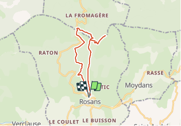
Randonnée Marche de 12,1 km à découvrir à Provence-Alpes-Côte d'Azur, Hautes-Alpes, Rosans. Cette randonnée est proposée par Marco05.
Description
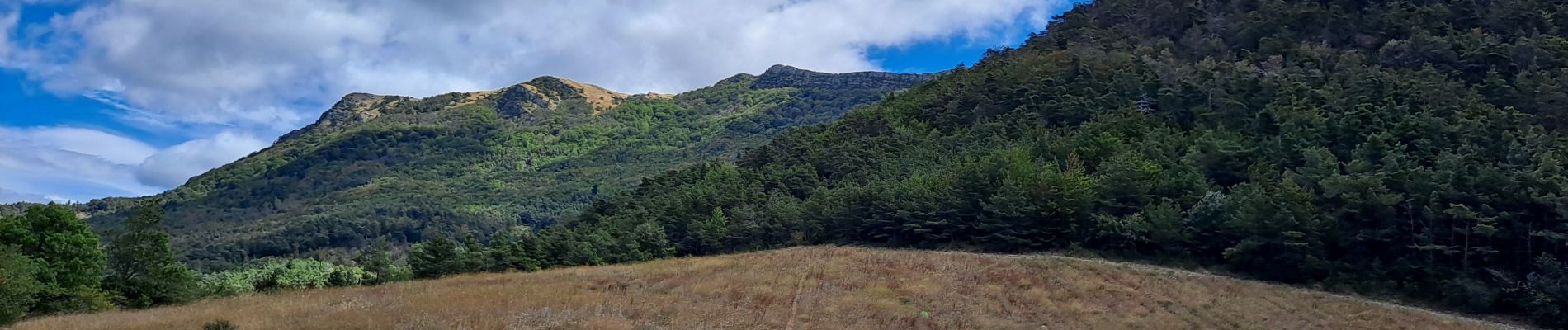
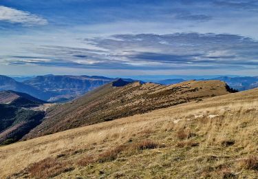
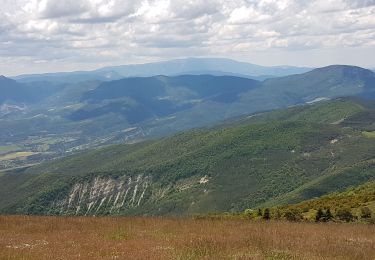
Un beau sommet au nord de Rosans.
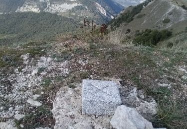
L'arête finale est un peu technique et un peu exposé côté gauche.
Prudence en cas de grand vent.
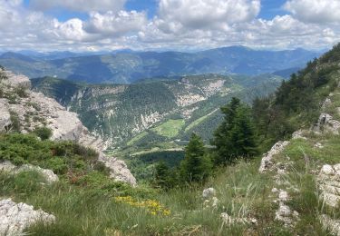
Au sommet le point de vue est splendide.
Demande une bonne condition physique.
Localisation
Pays :
France
Région :
Provence-Alpes-Côte d'Azur
Département/Province :
Hautes-Alpes
Commune :
Rosans
Localité :
Unknown
Départ:(Dec)
Départ:(UTM)
696771 ; 4918519 (31T) N.
Commentaires
Randonnées à proximité
![Randonnée Marche nordique Rosans - Crêtes du raton à partir du col de Pommerol - Photo](https://media.geolcdn.com/t/375/260/ce74893b-bcd8-461a-8afe-7c5344df54b3.jpg&format=jpg&maxdim=2)
![Marche nordique Marche nordique](https://static1.geolcdn.com/sitytour/trail-icons/102.png)
Crêtes du raton à partir du col de Pommerol
Marche nordique
Difficile
Rosans,
Provence-Alpes-Côte d'Azur,
Hautes-Alpes,
France
![](/images/other/stat-length.png)
5,8 km | 10,9 km-effort
3h 14min
![](https://static1.geolcdn.com/siteimages/upload/files/16400158638029165_repeat_loop_refresh_sync_direction_icon.png)
Oui
![Randonnée Marche Saint-André-de-Rosans - 05 risou - Photo](https://media.geolcdn.com/t/375/260/886b94ce-dd23-4d47-93fa-da54bf563cfa.jpg&format=jpg&maxdim=2)
![Marche Marche](https://static1.geolcdn.com/sitytour/trail-icons/101.png)
05 risou
Marche
Moyen
Saint-André-de-Rosans,
Provence-Alpes-Côte d'Azur,
Hautes-Alpes,
France
![](/images/other/stat-length.png)
15,4 km | 25 km-effort
7h 16min
![](https://static1.geolcdn.com/siteimages/upload/files/16400158638029165_repeat_loop_refresh_sync_direction_icon.png)
Non
![Randonnée Marche Rosans - Crête de Raton Via Raton - Photo](https://media.geolcdn.com/t/375/260/3e9ccc6f-4f06-44dd-9d37-5eaabb2c9ea0.jpg&format=jpg&maxdim=2)
![Marche Marche](https://static1.geolcdn.com/sitytour/trail-icons/101.png)
Crête de Raton Via Raton
Marche
Très difficile
Rosans,
Provence-Alpes-Côte d'Azur,
Hautes-Alpes,
France
![](/images/other/stat-length.png)
12,6 km | 23 km-effort
5h 13min
![](https://static1.geolcdn.com/siteimages/upload/files/16400158638029165_repeat_loop_refresh_sync_direction_icon.png)
Oui
![Randonnée Marche Rosans - 7km Fourchat AR par chemin du facteur (partie) - Photo](https://media.geolcdn.com/t/375/260/18cea4ea-f64c-464e-b93c-f5601bfe95d1.jpg&format=jpg&maxdim=2)
![Marche Marche](https://static1.geolcdn.com/sitytour/trail-icons/101.png)
7km Fourchat AR par chemin du facteur (partie)
Marche
Difficile
Rosans,
Provence-Alpes-Côte d'Azur,
Hautes-Alpes,
France
![](/images/other/stat-length.png)
6,8 km | 13,2 km-effort
3h 30min
![](https://static1.geolcdn.com/siteimages/upload/files/16400158638029165_repeat_loop_refresh_sync_direction_icon.png)
Oui
![Randonnée Marche Rosans - Le Fourchat par le col de Pommerol - Photo](https://media.geolcdn.com/t/375/260/cfab902e-83fa-4d54-aaa2-8926b38ea959.jpg&format=jpg&maxdim=2)
![Marche Marche](https://static1.geolcdn.com/sitytour/trail-icons/101.png)
Le Fourchat par le col de Pommerol
Marche
Moyen
Rosans,
Provence-Alpes-Côte d'Azur,
Hautes-Alpes,
France
![](/images/other/stat-length.png)
2,6 km | 7,3 km-effort
57min
![](https://static1.geolcdn.com/siteimages/upload/files/16400158638029165_repeat_loop_refresh_sync_direction_icon.png)
Non
![Randonnée Marche Rosans - Montagne de Raton au départ du col de Pommerol ou de la Fromagère - Photo](https://media.geolcdn.com/t/375/260/88563a29-0d69-4d1d-a9a8-ed2b63e53039.jpg&format=jpg&maxdim=2)
![Marche Marche](https://static1.geolcdn.com/sitytour/trail-icons/101.png)
Montagne de Raton au départ du col de Pommerol ou de la Fromagère
Marche
Moyen
(1)
Rosans,
Provence-Alpes-Côte d'Azur,
Hautes-Alpes,
France
![](/images/other/stat-length.png)
6,8 km | 12,1 km-effort
7h 29min
![](https://static1.geolcdn.com/siteimages/upload/files/16400158638029165_repeat_loop_refresh_sync_direction_icon.png)
Oui
![Randonnée Marche Rosans - POMMEROL - LA MONTAGNE DE RATON - Photo](https://media.geolcdn.com/t/375/260/904beef7-15df-4454-b310-e33a491109ff.jpg&format=jpg&maxdim=2)
![Marche Marche](https://static1.geolcdn.com/sitytour/trail-icons/101.png)
POMMEROL - LA MONTAGNE DE RATON
Marche
Difficile
Rosans,
Provence-Alpes-Côte d'Azur,
Hautes-Alpes,
France
![](/images/other/stat-length.png)
7,1 km | 12,4 km-effort
6h 49min
![](https://static1.geolcdn.com/siteimages/upload/files/16400158638029165_repeat_loop_refresh_sync_direction_icon.png)
Oui
![Randonnée Marche Saint-André-de-Rosans - SAINT ANDRE DE ROSANS - SERRE DE BOUT - Photo](https://media.geolcdn.com/t/375/260/73bdb372-6b96-4f24-8ee0-8d047a0b55f7.jpg&format=jpg&maxdim=2)
![Marche Marche](https://static1.geolcdn.com/sitytour/trail-icons/101.png)
SAINT ANDRE DE ROSANS - SERRE DE BOUT
Marche
Facile
Saint-André-de-Rosans,
Provence-Alpes-Côte d'Azur,
Hautes-Alpes,
France
![](/images/other/stat-length.png)
9,7 km | 13,6 km-effort
7h 48min
![](https://static1.geolcdn.com/siteimages/upload/files/16400158638029165_repeat_loop_refresh_sync_direction_icon.png)
Oui
![Randonnée V.T.T. Rosans - HA J2 long - Photo](https://media.geolcdn.com/t/375/260/ext.jpg?maxdim=2&url=https%3A%2F%2Fstatic1.geolcdn.com%2Fsiteimages%2Fupload%2Ffiles%2F1524743154velo.jpg)
![V.T.T. V.T.T.](https://static1.geolcdn.com/sitytour/trail-icons/202.png)
HA J2 long
V.T.T.
Très facile
(2)
Rosans,
Provence-Alpes-Côte d'Azur,
Hautes-Alpes,
France
![](/images/other/stat-length.png)
48 km | 65 km-effort
4h 12min
![](https://static1.geolcdn.com/siteimages/upload/files/16400158638029165_repeat_loop_refresh_sync_direction_icon.png)
Non