Randonnée V.T.T. Vennecy - 20230827 vtt - Photo
 benquad45
benquad45

Utilisateur

© OpenStreetMap contributors
Longueur
Longueur
30 km
Altitude max
Altitude max
153 m
Dénivelé positif
Dénivelé positif
198 m
Km-Effort
Km-Effort  
32 km
Altitude min
Altitude min
103 m
Dénivelé négatif
Dénivelé négatif
198 m
Boucle
Boucle
Oui
Date de création :
2023-08-27 06:52:24.0
Dernière modification :
2023-08-27 08:46:28.91

(0 Avis)

V.T.T.
V.T.T.
1h53
Difficulté : Facile

Scannez ce code QR pour ouvrir la randonnée dans l'application SityTrail

Application GPS de randonnée GRATUITE

Logo SityTrail SityTrail

IGN / Instituts géographiques

Télécharger SityTrail sur l'App Store Télécharger SityTrail sur Google Play

Logo SityTrail SityTrail World

Le monde est à vous

Télécharger SityTrail sur l'App Store Télécharger SityTrail sur Google Play Télécharger SityTrail sur Huawei AppGallery

À propos

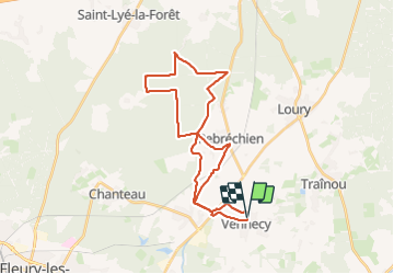
Randonnée V.T.T. de 30 km à découvrir à Centre-Val de Loire, Loiret, Vennecy. Cette randonnée est proposée par benquad45.

Profil altimétrique

Localisation

Pays :
France
Région :
Centre-Val de Loire
Département/Province :
Loiret
Commune :
Vennecy
Localité :
Unknown
Départ:(Dec)
Départ:(UTM)
429486 ; 5311870 (31T) N.

Randonnées à proximité

Randonnée V.T.T. Saint-Jean-de-Braye - Du château de Charbonnière au château de Chamerolles - Photo
V.T.T.
tracegps

V.T.T.

Moyen
Saint-Jean-de-Braye, Centre-Val de Loire, Loiret, France
36 km | 40 km-effort
3h 0min
Non
Randonnée Marche Vennecy - Chemins d'autrefois - Vennecy  - Photo
Marche
tracegps

Marche

Moyen
Vennecy, Centre-Val de Loire, Loiret, France
11,1 km | 11,8 km-effort
2h 45min
Oui
Randonnée sport Donnery - Sob 6 Donnery clery.  - Photo
sport
Glurps

sport

Très facile
Donnery, Centre-Val de Loire, Loiret, France
35 km | 38 km-effort
Inconnu
Non
Randonnée A pied Marigny-les-Usages - PR de la Forêt - Photo
A pied
GUIDE+

A pied

Facile
Marigny-les-Usages, Centre-Val de Loire, Loiret, France
6,7 km | 7,5 km-effort
1h 41min
Oui
Randonnée A pied Marigny-les-Usages - PR des Champs - Photo
A pied
GUIDE+

A pied

Facile
Marigny-les-Usages, Centre-Val de Loire, Loiret, France
6,9 km | 7,5 km-effort
1h 41min
Oui
Randonnée Marche Saint-Jean-de-Braye - Charbonnière 2 - Photo
Marche
JiDi

Marche

Saint-Jean-de-Braye, Centre-Val de Loire, Loiret, France
4,5 km | 5 km-effort
1h 4min
Oui
Randonnée V.T.C. Vennecy - 20230120 Forêt et Canal - Photo
V.T.C.
benquad45

V.T.C.

Vennecy, Centre-Val de Loire, Loiret, France
53 km | 58 km-effort
3h 16min
Oui
Randonnée V.T.T. Vennecy - 20231111 vtt elec - Photo
V.T.T.
benquad45

V.T.T.

Facile
Vennecy, Centre-Val de Loire, Loiret, France
29 km | 32 km-effort
1h 43min
Oui
Randonnée Marche Saint-Jean-de-Braye - château de la charbonniere - Photo
Marche
wajdi charguia

Marche

Moyen
Saint-Jean-de-Braye, Centre-Val de Loire, Loiret, France
7,6 km | 8,4 km-effort
1h 54min
Oui


Fermer
Mes abonnements