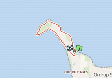
![](/images/other/stat-length.png)
Danemark: Tour de l'Ordrup Naes
jlrayon
Utilisateur
![Longueur](/images/other/stat-length.png)
Longueur
4,3 km
![Altitude max](https://static1.geolcdn.com/siteimages/upload/files/1508320355ic_sort_altitude_max_24dp.png)
Altitude max
14 m
![Dénivelé positif](https://static1.geolcdn.com/siteimages/upload/files/1508320355ic_sort_den_pos_24dp.png)
Dénivelé positif
24 m
![Km-Effort](/images/other/stat-length.png)
Km-Effort
4,6 km
![Altitude min](https://static1.geolcdn.com/siteimages/upload/files/1508320355ic_sort_altitude_min_24dp.png)
Altitude min
0 m
![Dénivelé négatif](https://static1.geolcdn.com/siteimages/upload/files/1508320355ic_sort_den_neg_24dp.png)
Dénivelé négatif
26 m
![Boucle](https://static1.geolcdn.com/siteimages/upload/files/16400158638029165_repeat_loop_refresh_sync_direction_icon.png)
Boucle
Oui
Date de création :
2023-08-17 12:36:58.795
Dernière modification :
2023-08-22 17:24:39.784
![Marche](https://static1.geolcdn.com/sitytour/trail-icons/101.png)
1h02
Difficulté : Facile
![Scannez ce code QR pour ouvrir la randonnée dans l'application SityTrail](https://capi.geolives.com/qq0zvz2zws4bq2lad0pu/sitytour/trails/3775303/qr.png?size=200)
Application GPS de randonnée GRATUITE
À propos
Randonnée Marche de 4,3 km à découvrir à Region Sjælland. Cette randonnée est proposée par jlrayon.
Description
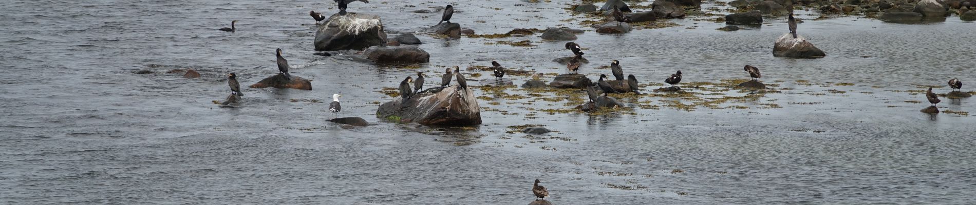
Superbe petite randonnée dans un paysage de bout du monde, moutons, oiseaux migrateurs, avec un peu de chance vous pourrez apercevoir l'eider sauvage du Danemark qui à donné son nom et son duvet à l'édredon.
Localisation
Pays :
Danemark
Région :
Region Sjælland
Département/Province :
Unknown
Commune :
Unknown
Localité :
Unknown
Départ:(Dec)
Départ:(UTM)
648834 ; 6190208 (32U) N.
Commentaires
Randonnées à proximité
![Randonnée A pied - 360 graders udsigt - Photo](https://media.geolcdn.com/t/375/260/14e3955d-4f40-4e8f-a669-441034b16c5e.jpeg&format=jpg&maxdim=2)
![A pied A pied](https://static1.geolcdn.com/sitytour/trail-icons/100.png)
![Randonnée A pied - Ordrup næs - Korup skov - Photo](https://media.geolcdn.com/t/375/260/5002f6d1-545e-4871-b4eb-3ca183389bb1.jpeg&format=jpg&maxdim=2)
![A pied A pied](https://static1.geolcdn.com/sitytour/trail-icons/100.png)
Ordrup næs - Korup skov
A pied
Facile
,
Region Sjælland,
,
Danemark
![](/images/other/stat-length.png)
6,9 km | 7,6 km-effort
1h 44min
![](https://static1.geolcdn.com/siteimages/upload/files/16400158638029165_repeat_loop_refresh_sync_direction_icon.png)
Non
![Randonnée Marche - Ordrup tour de la forêt - Photo](https://media.geolcdn.com/t/375/260/ext.jpg?maxdim=2&url=https%3A%2F%2Fstatic1.geolcdn.com%2Fsiteimages%2Fupload%2Ffiles%2F1553511878bg_sport_marche.png)
![Marche Marche](https://static1.geolcdn.com/sitytour/trail-icons/101.png)
Ordrup tour de la forêt
Marche
Facile
,
Region Sjælland,
,
Danemark
![](/images/other/stat-length.png)
4,5 km | 4,9 km-effort
1h 7min
![](https://static1.geolcdn.com/siteimages/upload/files/16400158638029165_repeat_loop_refresh_sync_direction_icon.png)
Oui
![Randonnée Marche - Ordrup : vallée de l'aventure - Photo](https://media.geolcdn.com/t/375/260/ext.jpg?maxdim=2&url=https%3A%2F%2Fstatic1.geolcdn.com%2Fsiteimages%2Fupload%2Ffiles%2F1553511878bg_sport_marche.png)
![Marche Marche](https://static1.geolcdn.com/sitytour/trail-icons/101.png)
Ordrup : vallée de l'aventure
Marche
Facile
,
Region Sjælland,
,
Danemark
![](/images/other/stat-length.png)
4,8 km | 5,2 km-effort
3h 30min
![](https://static1.geolcdn.com/siteimages/upload/files/16400158638029165_repeat_loop_refresh_sync_direction_icon.png)
Oui