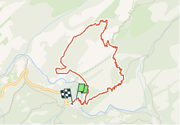
![](/images/other/stat-length.png)
![Randonnée Marche Calenzana - Boucle finocchi - Photo](https://media.geolcdn.com/t/1900/400/ext.pjpeg?maxdim=2&url=https%3A%2F%2Fstatic1.geolcdn.com%2Fsiteimages%2Fupload%2Ffiles%2F1553511878bg_sport_marche.png)
Boucle finocchi
colasmar
Utilisateur
![Longueur](/images/other/stat-length.png)
![Altitude max](https://static1.geolcdn.com/siteimages/upload/files/1508320355ic_sort_altitude_max_24dp.png)
![Dénivelé positif](https://static1.geolcdn.com/siteimages/upload/files/1508320355ic_sort_den_pos_24dp.png)
![Km-Effort](/images/other/stat-length.png)
![Altitude min](https://static1.geolcdn.com/siteimages/upload/files/1508320355ic_sort_altitude_min_24dp.png)
![Dénivelé négatif](https://static1.geolcdn.com/siteimages/upload/files/1508320355ic_sort_den_neg_24dp.png)
![Boucle](https://static1.geolcdn.com/siteimages/upload/files/16400158638029165_repeat_loop_refresh_sync_direction_icon.png)
![Marche](https://static1.geolcdn.com/sitytour/trail-icons/101.png)
2h47
Difficulté : Difficile
![Scannez ce code QR pour ouvrir la randonnée dans l'application SityTrail](https://capi.geolives.com/qq0zvz2zws4bq2lad0pu/sitytour/trails/3775170/qr.png?size=200)
Application GPS de randonnée GRATUITE
À propos
Randonnée Marche de 5,9 km à découvrir à Corse, Haute-Corse, Calenzana. Cette randonnée est proposée par colasmar.
Description
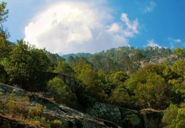
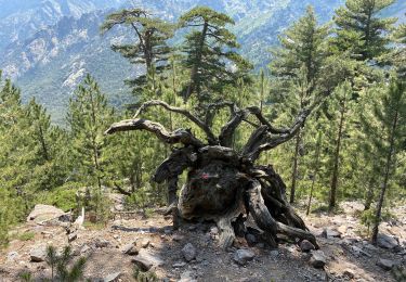
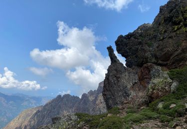
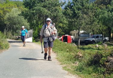
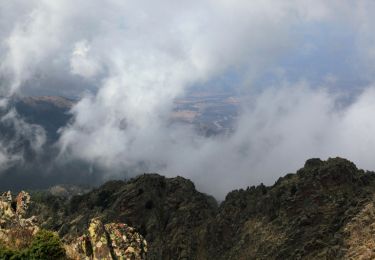
Courte mais assez physique surtout si on part trop tard car c’est une bonne partie en plein soleil. Enfin si on fait la boucle en sens horaire. D’ailleurs dans ce sens la montée est vraiment raide. Mais si on le prend en sens inverse la descente sera peut être pire car nous sommes sur des sentiers de pierres et de cailloux qui roulent. Attention à avoir de très bonne chaussures qui accrochent. Sinon, il y a peu de chose à voir si on apprécier le chemin et la vue sur la vallée et la plaine au loin.
Localisation
Commentaires
Randonnées à proximité
![Randonnée Marche Calenzana - Mare e Monti - De Bonifatu à Tuarelli - Photo](https://media.geolcdn.com/t/375/260/ext.jpg?maxdim=2&url=https%3A%2F%2Fservices.sitytrail.com%2FGeolivesWS%2FDownloadMedia.ashx%3FTrailID%3D109774%26Media%3D4704_1.jpg)
![Marche Marche](https://static1.geolcdn.com/sitytour/trail-icons/101.png)
Marche
![](/images/other/stat-length.png)
![](https://static1.geolcdn.com/siteimages/upload/files/16400158638029165_repeat_loop_refresh_sync_direction_icon.png)
![Randonnée Marche Calenzana - Frankrijk - Calvi - Cirque de Bonifatu - Corsica - Photo](https://media.geolcdn.com/t/375/260/ext.jpg?maxdim=2&url=https%3A%2F%2Fstatic1.geolcdn.com%2Fsiteimages%2Fupload%2Ffiles%2F1553511878bg_sport_marche.png)
![Marche Marche](https://static1.geolcdn.com/sitytour/trail-icons/101.png)
Marche
![](/images/other/stat-length.png)
![](https://static1.geolcdn.com/siteimages/upload/files/16400158638029165_repeat_loop_refresh_sync_direction_icon.png)
![Randonnée Marche Calenzana - Gr20 Caruzzo Ascorbique - Photo](https://media.geolcdn.com/t/375/260/283be13d-2a81-40ab-b602-c3c97bf8108c.jpg&format=jpg&maxdim=2)
![Marche Marche](https://static1.geolcdn.com/sitytour/trail-icons/101.png)
Marche
![](/images/other/stat-length.png)
![](https://static1.geolcdn.com/siteimages/upload/files/16400158638029165_repeat_loop_refresh_sync_direction_icon.png)
![Randonnée Marche Calenzana - Ortu di u piobbu. Carozzu - Photo](https://media.geolcdn.com/t/375/260/89350b82-74c0-4665-8cba-390c49fa51b8.jpg&format=jpg&maxdim=2)
![Marche Marche](https://static1.geolcdn.com/sitytour/trail-icons/101.png)
Marche
![](/images/other/stat-length.png)
![](https://static1.geolcdn.com/siteimages/upload/files/16400158638029165_repeat_loop_refresh_sync_direction_icon.png)
![Randonnée Marche Calenzana - Bonifatu Tureli - Photo](https://media.geolcdn.com/t/375/260/43d6c65f-9dda-4c36-a7b0-78874af4ae55.jpg&format=jpg&maxdim=2)
![Marche Marche](https://static1.geolcdn.com/sitytour/trail-icons/101.png)
Marche
![](/images/other/stat-length.png)
![](https://static1.geolcdn.com/siteimages/upload/files/16400158638029165_repeat_loop_refresh_sync_direction_icon.png)
![Randonnée A pied Calenzana - Chemin de Pinzu a Stramba - Refuge D'Ortu di u Piobbu - Photo](https://media.geolcdn.com/t/375/260/c6dc7dc8-9826-4269-a7c8-c8fe1fcbebcd.jpeg&format=jpg&maxdim=2)
![A pied A pied](https://static1.geolcdn.com/sitytour/trail-icons/100.png)
A pied
![](/images/other/stat-length.png)
![](https://static1.geolcdn.com/siteimages/upload/files/16400158638029165_repeat_loop_refresh_sync_direction_icon.png)
![Randonnée A pied Calenzana - Chemin de Melaghja - Refuge D'Ortu di u Piobbu - Photo](https://media.geolcdn.com/t/375/260/78f02bd9-fff6-492b-90db-c5af90353527.jpeg&format=jpg&maxdim=2)
![A pied A pied](https://static1.geolcdn.com/sitytour/trail-icons/100.png)
A pied
![](/images/other/stat-length.png)
![](https://static1.geolcdn.com/siteimages/upload/files/16400158638029165_repeat_loop_refresh_sync_direction_icon.png)
![Randonnée Marche Calenzana - Bonifatu Carozzu Bocca Ignominata Spasimata - Photo](https://media.geolcdn.com/t/375/260/1e5cf81e-10fb-492e-a4d1-67efd1a344e6.jpg&format=jpg&maxdim=2)
![Marche Marche](https://static1.geolcdn.com/sitytour/trail-icons/101.png)
Marche
![](/images/other/stat-length.png)
![](https://static1.geolcdn.com/siteimages/upload/files/16400158638029165_repeat_loop_refresh_sync_direction_icon.png)
![Randonnée Marche Calenzana - La boucle du Ceppu - Bonifatu - Photo](https://media.geolcdn.com/t/375/260/ext.jpg?maxdim=2&url=https%3A%2F%2Fservices.sitytrail.com%2FGeolivesWS%2FDownloadMedia.ashx%3FTrailID%3D107329%26Media%3D12219_6.jpg)
![Marche Marche](https://static1.geolcdn.com/sitytour/trail-icons/101.png)
Marche
![](/images/other/stat-length.png)
![](https://static1.geolcdn.com/siteimages/upload/files/16400158638029165_repeat_loop_refresh_sync_direction_icon.png)