![](/images/other/stat-length.png)
![Randonnée Marche Civrieux-d'Azergues - A_CIVRIEUX D'AZERGUES 69380 Dommartin - Bruyère Marand - Photo](https://media.geolcdn.com/t/1900/400/ext.pjpeg?maxdim=2&url=https%3A%2F%2Fstatic1.geolcdn.com%2Fsiteimages%2Fupload%2Ffiles%2F1553511878bg_sport_marche.png)
A_CIVRIEUX D'AZERGUES 69380 Dommartin - Bruyère Marand
ANDREJAC
Utilisateur
![Longueur](/images/other/stat-length.png)
Longueur
9,7 km
![Altitude max](https://static1.geolcdn.com/siteimages/upload/files/1508320355ic_sort_altitude_max_24dp.png)
Altitude max
298 m
![Dénivelé positif](https://static1.geolcdn.com/siteimages/upload/files/1508320355ic_sort_den_pos_24dp.png)
Dénivelé positif
160 m
![Km-Effort](/images/other/stat-length.png)
Km-Effort
11,9 km
![Altitude min](https://static1.geolcdn.com/siteimages/upload/files/1508320355ic_sort_altitude_min_24dp.png)
Altitude min
194 m
![Dénivelé négatif](https://static1.geolcdn.com/siteimages/upload/files/1508320355ic_sort_den_neg_24dp.png)
Dénivelé négatif
161 m
![Boucle](https://static1.geolcdn.com/siteimages/upload/files/16400158638029165_repeat_loop_refresh_sync_direction_icon.png)
Boucle
Oui
Date de création :
2015-02-24 00:00:00.0
Dernière modification :
2015-02-24 00:00:00.0
![Marche](https://static1.geolcdn.com/sitytour/trail-icons/101.png)
3h00
Difficulté : Facile
![Scannez ce code QR pour ouvrir la randonnée dans l'application SityTrail](https://capi.geolives.com/qq0zvz2zws4bq2lad0pu/sitytour/trails/376793/qr.png?size=200)
Application GPS de randonnée GRATUITE
À propos
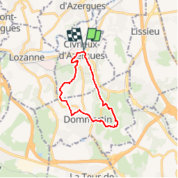
Randonnée Marche de 9,7 km à découvrir à Auvergne-Rhône-Alpes, Rhône, Civrieux-d'Azergues. Cette randonnée est proposée par ANDREJAC.
Description
Départ et retour parking de la mairie. Vers le Besson, la Bergeonnière, Dommartin (le Prost), les Bois Communaux, le Grand Taillis, Chardon Marand, Marand, le Rontet, mairie.
Localisation
Pays :
France
Région :
Auvergne-Rhône-Alpes
Département/Province :
Rhône
Commune :
Civrieux-d'Azergues
Localité :
Unknown
Départ:(Dec)
Départ:(UTM)
632916 ; 5079749 (31T) N.
Commentaires
Randonnées à proximité
![Randonnée V.T.T. Lozanne - La 5ème Vélozannaise (2014-VTT-45km) - Lozanne - Photo](https://media.geolcdn.com/t/375/260/ext.jpg?maxdim=2&url=https%3A%2F%2Fservices.sitytrail.com%2FGeolivesWS%2FDownloadMedia.ashx%3FTrailID%3D318042%26Media%3D17513_6.jpg)
![V.T.T. V.T.T.](https://static1.geolcdn.com/sitytour/trail-icons/202.png)
La 5ème Vélozannaise (2014-VTT-45km) - Lozanne
V.T.T.
Difficile
(1)
Lozanne,
Auvergne-Rhône-Alpes,
Rhône,
France
![](/images/other/stat-length.png)
45 km | 59 km-effort
3h 45min
![](https://static1.geolcdn.com/siteimages/upload/files/16400158638029165_repeat_loop_refresh_sync_direction_icon.png)
Oui
![Randonnée Marche Lentilly - Santier des vaches LENTILLY - Photo](https://media.geolcdn.com/t/375/260/571590e7-6ce0-4ff1-b403-0f445cf01256.jpg&format=jpg&maxdim=2)
![Marche Marche](https://static1.geolcdn.com/sitytour/trail-icons/101.png)
Santier des vaches LENTILLY
Marche
Très facile
(1)
Lentilly,
Auvergne-Rhône-Alpes,
Rhône,
France
![](/images/other/stat-length.png)
3,2 km | 4,1 km-effort
51min
![](https://static1.geolcdn.com/siteimages/upload/files/16400158638029165_repeat_loop_refresh_sync_direction_icon.png)
Oui
![Randonnée Course à pied Limonest - Monts d'Or - Limonest - Photo](https://media.geolcdn.com/t/375/260/ext.jpg?maxdim=2&url=https%3A%2F%2Fservices.sitytrail.com%2FGeolivesWS%2FDownloadMedia.ashx%3FTrailID%3D118776%26Media%3D12977_1.jpg)
![Course à pied Course à pied](https://static1.geolcdn.com/sitytour/trail-icons/103.png)
Monts d'Or - Limonest
Course à pied
Moyen
(2)
Limonest,
Auvergne-Rhône-Alpes,
Métropole de Lyon,
France
![](/images/other/stat-length.png)
21 km | 32 km-effort
2h 0min
![](https://static1.geolcdn.com/siteimages/upload/files/16400158638029165_repeat_loop_refresh_sync_direction_icon.png)
Oui
![Randonnée Randonnée équestre Chasselay - chasselay florian alain - Photo](https://media.geolcdn.com/t/375/260/ext.jpg?maxdim=2&url=https%3A%2F%2Fstatic1.geolcdn.com%2Fsiteimages%2Fupload%2Ffiles%2F1524743154cheval.jpg)
![Randonnée équestre Randonnée équestre](https://static1.geolcdn.com/sitytour/trail-icons/301.png)
chasselay florian alain
Randonnée équestre
Facile
(1)
Chasselay,
Auvergne-Rhône-Alpes,
Rhône,
France
![](/images/other/stat-length.png)
13,3 km | 17,3 km-effort
2h 16min
![](https://static1.geolcdn.com/siteimages/upload/files/16400158638029165_repeat_loop_refresh_sync_direction_icon.png)
Oui
![Randonnée A pied Saint-Jean-des-Vignes - De Bagnols à Lozanne - Photo](https://media.geolcdn.com/t/375/260/0483cf43-fc67-45ae-bc2f-363ddcb48e98.jpeg&format=jpg&maxdim=2)
![A pied A pied](https://static1.geolcdn.com/sitytour/trail-icons/100.png)
De Bagnols à Lozanne
A pied
Facile
Saint-Jean-des-Vignes,
Auvergne-Rhône-Alpes,
Rhône,
France
![](/images/other/stat-length.png)
4 km | 5 km-effort
1h 7min
![](https://static1.geolcdn.com/siteimages/upload/files/16400158638029165_repeat_loop_refresh_sync_direction_icon.png)
Non
![Randonnée A pied Lozanne - De Lozanne à Marcy - Photo](https://media.geolcdn.com/t/375/260/08fe2957-d9d7-452a-b8d4-1f5434bd4ed8.jpeg&format=jpg&maxdim=2)
![A pied A pied](https://static1.geolcdn.com/sitytour/trail-icons/100.png)
De Lozanne à Marcy
A pied
Facile
Lozanne,
Auvergne-Rhône-Alpes,
Rhône,
France
![](/images/other/stat-length.png)
12,2 km | 15,6 km-effort
3h 32min
![](https://static1.geolcdn.com/siteimages/upload/files/16400158638029165_repeat_loop_refresh_sync_direction_icon.png)
Non
![Randonnée Marche Dommartin - A_DOMMARTIN 69380 Civrieux - Marand - Photo](https://media.geolcdn.com/t/375/260/ext.jpg?maxdim=2&url=https%3A%2F%2Fstatic1.geolcdn.com%2Fsiteimages%2Fupload%2Ffiles%2F1553511878bg_sport_marche.png)
![Marche Marche](https://static1.geolcdn.com/sitytour/trail-icons/101.png)
A_DOMMARTIN 69380 Civrieux - Marand
Marche
Facile
(1)
Dommartin,
Auvergne-Rhône-Alpes,
Rhône,
France
![](/images/other/stat-length.png)
10,1 km | 12,2 km-effort
3h 0min
![](https://static1.geolcdn.com/siteimages/upload/files/16400158638029165_repeat_loop_refresh_sync_direction_icon.png)
Oui
![Randonnée Marche Saint-Jean-des-Vignes - A_ST JEAN DES VIGNES 69380 Pierre Folle - Fontainebleau - Photo](https://media.geolcdn.com/t/375/260/ext.jpg?maxdim=2&url=https%3A%2F%2Fstatic1.geolcdn.com%2Fsiteimages%2Fupload%2Ffiles%2F1553511878bg_sport_marche.png)
![Marche Marche](https://static1.geolcdn.com/sitytour/trail-icons/101.png)
A_ST JEAN DES VIGNES 69380 Pierre Folle - Fontainebleau
Marche
Facile
(1)
Saint-Jean-des-Vignes,
Auvergne-Rhône-Alpes,
Rhône,
France
![](/images/other/stat-length.png)
8 km | 11 km-effort
3h 0min
![](https://static1.geolcdn.com/siteimages/upload/files/16400158638029165_repeat_loop_refresh_sync_direction_icon.png)
Oui
![Randonnée Marche Morancé - morance - Photo](https://media.geolcdn.com/t/375/260/ext.jpg?maxdim=2&url=https%3A%2F%2Fstatic1.geolcdn.com%2Fsiteimages%2Fupload%2Ffiles%2F1553511878bg_sport_marche.png)
![Marche Marche](https://static1.geolcdn.com/sitytour/trail-icons/101.png)
morance
Marche
Très facile
(1)
Morancé,
Auvergne-Rhône-Alpes,
Rhône,
France
![](/images/other/stat-length.png)
7,9 km | 9,7 km-effort
1h 46min
![](https://static1.geolcdn.com/siteimages/upload/files/16400158638029165_repeat_loop_refresh_sync_direction_icon.png)
Oui