![](/images/other/stat-length.png)
![Randonnée Marche Orcières - Roc Diolon par le col de Freissinières - Photo](https://media.geolcdn.com/t/1900/400/5a167a74-49bc-4637-b777-9bd30e412110.jpg&format=pjpeg&maxdim=2)
Roc Diolon par le col de Freissinières
R@ph
Utilisateur GUIDE
![Longueur](/images/other/stat-length.png)
![Altitude max](https://static1.geolcdn.com/siteimages/upload/files/1508320355ic_sort_altitude_max_24dp.png)
![Dénivelé positif](https://static1.geolcdn.com/siteimages/upload/files/1508320355ic_sort_den_pos_24dp.png)
![Km-Effort](/images/other/stat-length.png)
![Altitude min](https://static1.geolcdn.com/siteimages/upload/files/1508320355ic_sort_altitude_min_24dp.png)
![Dénivelé négatif](https://static1.geolcdn.com/siteimages/upload/files/1508320355ic_sort_den_neg_24dp.png)
![Boucle](https://static1.geolcdn.com/siteimages/upload/files/16400158638029165_repeat_loop_refresh_sync_direction_icon.png)
![Marche](https://static1.geolcdn.com/sitytour/trail-icons/101.png)
7h21
Difficulté : Très difficile
![Scannez ce code QR pour ouvrir la randonnée dans l'application SityTrail](https://capi.geolives.com/qq0zvz2zws4bq2lad0pu/sitytour/trails/3767929/qr.png?size=200)
Application GPS de randonnée GRATUITE
À propos
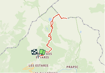
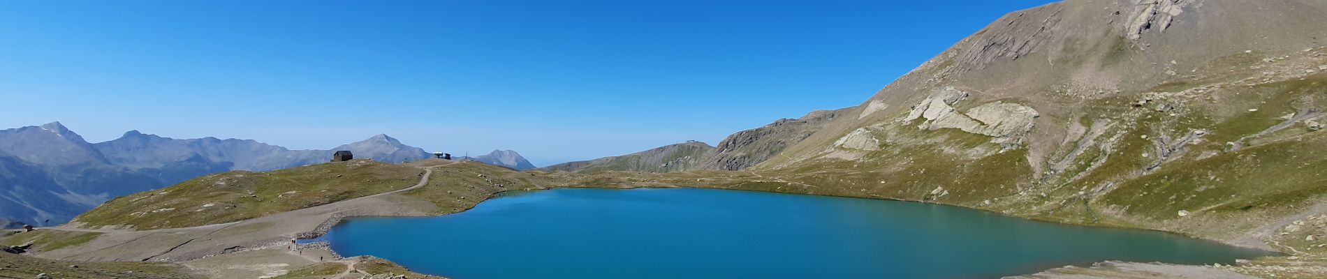
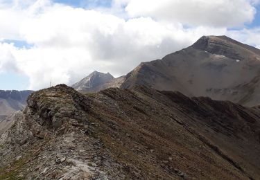
Randonnée Marche de 16,3 km à découvrir à Provence-Alpes-Côte d'Azur, Hautes-Alpes, Orcières. Cette randonnée est proposée par R@ph.
Description
Au départ de la station de Merlette, une randonnée qui passe par les Lacs, Jujal, Sirènes, Jumeaux et grand Estaris, ensuite direction le col de Freissinières puis montée jusqu'au Roc Diolon à 3071 m.
Il s'agit d'une très belle randonnée, sans difficulté technique qui offre au sommet un panorama à 360° magnifique.
Localisation
Commentaires
Randonnées à proximité
![Randonnée Marche Orcières - Le Forest des marches - Photo](https://media.geolcdn.com/t/375/260/1bbb2305-7ec0-44b0-abf9-1e50226e1407.jpg&format=jpg&maxdim=2)
![Marche Marche](https://static1.geolcdn.com/sitytour/trail-icons/101.png)
Marche
![](/images/other/stat-length.png)
![](https://static1.geolcdn.com/siteimages/upload/files/16400158638029165_repeat_loop_refresh_sync_direction_icon.png)
![Randonnée Marche Orcières - R45 Marmottes a Prapic - Photo](https://media.geolcdn.com/t/375/260/9e9dbd3a-1b41-4834-8fb6-1b5270d2390e.jpg&format=jpg&maxdim=2)
![Marche Marche](https://static1.geolcdn.com/sitytour/trail-icons/101.png)
Marche
![](/images/other/stat-length.png)
![](https://static1.geolcdn.com/siteimages/upload/files/16400158638029165_repeat_loop_refresh_sync_direction_icon.png)
![Randonnée Marche Orcières - Orcieres (Hautes Alpes) - Photo](https://media.geolcdn.com/t/375/260/8cda8352-22b8-4c39-b048-400b3169e428.jpg&format=jpg&maxdim=2)
![Marche Marche](https://static1.geolcdn.com/sitytour/trail-icons/101.png)
Marche
![](/images/other/stat-length.png)
![](https://static1.geolcdn.com/siteimages/upload/files/16400158638029165_repeat_loop_refresh_sync_direction_icon.png)
![Randonnée Ski de randonnée Orcières - L'homme de Prapic - Photo](https://media.geolcdn.com/t/375/260/728ac5de-7771-4482-8258-55cd8c2ebd98.jpg&format=jpg&maxdim=2)
![Ski de randonnée Ski de randonnée](https://static1.geolcdn.com/sitytour/trail-icons/503.png)
Ski de randonnée
![](/images/other/stat-length.png)
![](https://static1.geolcdn.com/siteimages/upload/files/16400158638029165_repeat_loop_refresh_sync_direction_icon.png)
![Marche Marche](https://static1.geolcdn.com/sitytour/trail-icons/101.png)
Marche
![](/images/other/stat-length.png)
![](https://static1.geolcdn.com/siteimages/upload/files/16400158638029165_repeat_loop_refresh_sync_direction_icon.png)
![Randonnée Marche Orcières - Lac des Pisses - Photo](https://media.geolcdn.com/t/375/260/72d69359-d69b-4e79-86c6-e3022c079ec2.jpg&format=jpg&maxdim=2)
![Marche Marche](https://static1.geolcdn.com/sitytour/trail-icons/101.png)
Marche
![](/images/other/stat-length.png)
![](https://static1.geolcdn.com/siteimages/upload/files/16400158638029165_repeat_loop_refresh_sync_direction_icon.png)
![Randonnée Ski de randonnée Orcières - objectif Rocher blanc mais trop long donc direction chapeau rouge - Photo](https://media.geolcdn.com/t/375/260/7cce85a4-567c-43a2-8949-4f1bb1d57721.jpg&format=jpg&maxdim=2)
![Ski de randonnée Ski de randonnée](https://static1.geolcdn.com/sitytour/trail-icons/503.png)
Ski de randonnée
![](/images/other/stat-length.png)
![](https://static1.geolcdn.com/siteimages/upload/files/16400158638029165_repeat_loop_refresh_sync_direction_icon.png)
![Randonnée Ski de randonnée Orcières - Le chapeau rouge - Photo](https://media.geolcdn.com/t/375/260/4359da6c-2220-46c4-9d30-4f44fc07feb5.jpg&format=jpg&maxdim=2)
![Ski de randonnée Ski de randonnée](https://static1.geolcdn.com/sitytour/trail-icons/503.png)
Ski de randonnée
![](/images/other/stat-length.png)
![](https://static1.geolcdn.com/siteimages/upload/files/16400158638029165_repeat_loop_refresh_sync_direction_icon.png)
![Randonnée Marche Orcières - Col des Tourettes - Croix Lorraine - Photo](https://media.geolcdn.com/t/375/260/af57e72a-0044-4f3d-888f-9184aa14c00c.jpg&format=jpg&maxdim=2)
![Marche Marche](https://static1.geolcdn.com/sitytour/trail-icons/101.png)
Marche
![](/images/other/stat-length.png)
![](https://static1.geolcdn.com/siteimages/upload/files/16400158638029165_repeat_loop_refresh_sync_direction_icon.png)