![](/images/other/stat-length.png)
![Randonnée Vélo électrique Gand - Door de Scheldevallei - Photo](https://media.geolcdn.com/t/1900/400/ext.pjpeg?maxdim=2&url=https%3A%2F%2Fstatic1.geolcdn.com%2Fsiteimages%2Fupload%2Ffiles%2F1524743154velo.jpg)
Door de Scheldevallei
bometdehamer
Utilisateur
![Longueur](/images/other/stat-length.png)
Longueur
70 km
![Altitude max](https://static1.geolcdn.com/siteimages/upload/files/1508320355ic_sort_altitude_max_24dp.png)
Altitude max
31 m
![Dénivelé positif](https://static1.geolcdn.com/siteimages/upload/files/1508320355ic_sort_den_pos_24dp.png)
Dénivelé positif
452 m
![Km-Effort](/images/other/stat-length.png)
Km-Effort
76 km
![Altitude min](https://static1.geolcdn.com/siteimages/upload/files/1508320355ic_sort_altitude_min_24dp.png)
Altitude min
-3 m
![Dénivelé négatif](https://static1.geolcdn.com/siteimages/upload/files/1508320355ic_sort_den_neg_24dp.png)
Dénivelé négatif
452 m
![Boucle](https://static1.geolcdn.com/siteimages/upload/files/16400158638029165_repeat_loop_refresh_sync_direction_icon.png)
Boucle
Oui
Date de création :
2023-08-09 09:14:30.182
Dernière modification :
2023-08-10 08:08:47.406
![Vélo électrique](https://static1.geolcdn.com/sitytour/trail-icons/205.png)
4h28
Difficulté : Très facile
![Scannez ce code QR pour ouvrir la randonnée dans l'application SityTrail](https://capi.geolives.com/qq0zvz2zws4bq2lad0pu/sitytour/trails/3765622/qr.png?size=200)
Application GPS de randonnée GRATUITE
À propos
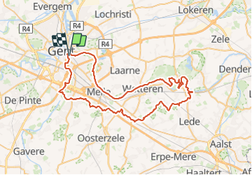
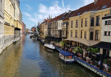
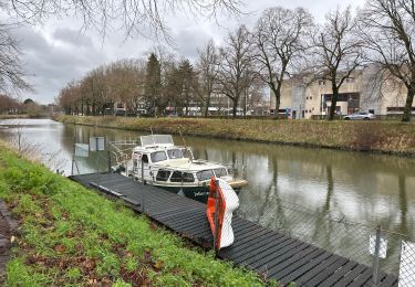
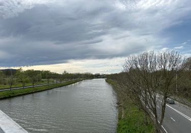
Randonnée Vélo électrique de 70 km à découvrir à Flandre, Flandre orientale, Gand. Cette randonnée est proposée par bometdehamer.
Description
Prachtige tocht van 70km langs de Schelde tot Wichelen en langs Serskamp, Westrem, Gontrode, Merelbeke terug naar Gent. Via KP 31,72,52,7,22,66,34,37,41,42,46,11,12,53,54,56,57,62,65,72,73,74,75,85,77,78,79,99,1,3,82,5,31
Localisation
Pays :
Belgique
Région :
Flandre
Département/Province :
Flandre orientale
Commune :
Gand
Localité :
Gand
Départ:(Dec)
Départ:(UTM)
552011 ; 5655367 (31U) N.
Commentaires
Randonnées à proximité
![Randonnée Vélo électrique Gand - Kastelentocht Sterretrappers 2 versie 3/7/2022 - Photo](https://media.geolcdn.com/t/375/260/2c827f43-8f51-42e6-8438-08eb0c46cfeb.jpg&format=jpg&maxdim=2)
![Vélo électrique Vélo électrique](https://static1.geolcdn.com/sitytour/trail-icons/205.png)
Kastelentocht Sterretrappers 2 versie 3/7/2022
Vélo électrique
Moyen
(1)
Gand,
Flandre,
Flandre orientale,
Belgique
![](/images/other/stat-length.png)
58 km | 62 km-effort
5h 52min
![](https://static1.geolcdn.com/siteimages/upload/files/16400158638029165_repeat_loop_refresh_sync_direction_icon.png)
Oui
![Vélo électrique Vélo électrique](https://static1.geolcdn.com/sitytour/trail-icons/205.png)
fietstocht 13-06-2021 sterretrappers
Vélo électrique
Très facile
(1)
Gand,
Flandre,
Flandre orientale,
Belgique
![](/images/other/stat-length.png)
33 km | 36 km-effort
Inconnu
![](https://static1.geolcdn.com/siteimages/upload/files/16400158638029165_repeat_loop_refresh_sync_direction_icon.png)
Oui
![Randonnée A pied Gand - Claeys-Boúúaert wandeling - Photo](https://media.geolcdn.com/t/375/260/921051f5-906e-47ac-b9c1-2a14046aee3f.jpeg&format=jpg&maxdim=2)
![A pied A pied](https://static1.geolcdn.com/sitytour/trail-icons/100.png)
Claeys-Boúúaert wandeling
A pied
Facile
Gand,
Flandre,
Flandre orientale,
Belgique
![](/images/other/stat-length.png)
9,3 km | 10 km-effort
2h 15min
![](https://static1.geolcdn.com/siteimages/upload/files/16400158638029165_repeat_loop_refresh_sync_direction_icon.png)
Oui
![Randonnée A pied Gand - Le Bourgoyen : Balade dans la vallée de la Leie gantoise - Photo](https://media.geolcdn.com/t/375/260/d0c2b3a9-5166-4f7a-9c9b-65fdd66fe07a.jpeg&format=jpg&maxdim=2)
![A pied A pied](https://static1.geolcdn.com/sitytour/trail-icons/100.png)
Le Bourgoyen : Balade dans la vallée de la Leie gantoise
A pied
Facile
Gand,
Flandre,
Flandre orientale,
Belgique
![](/images/other/stat-length.png)
5,1 km | 5,7 km-effort
1h 18min
![](https://static1.geolcdn.com/siteimages/upload/files/16400158638029165_repeat_loop_refresh_sync_direction_icon.png)
Oui
![Randonnée Marche Gand - Gand - Photo](https://media.geolcdn.com/t/375/260/becae5b4-1bd8-4ed9-a858-eb6535ae6c85.jpg&format=jpg&maxdim=2)
![Marche Marche](https://static1.geolcdn.com/sitytour/trail-icons/101.png)
Gand
Marche
Très facile
(1)
Gand,
Flandre,
Flandre orientale,
Belgique
![](/images/other/stat-length.png)
11,5 km | 12,5 km-effort
2h 40min
![](https://static1.geolcdn.com/siteimages/upload/files/16400158638029165_repeat_loop_refresh_sync_direction_icon.png)
Non
![Randonnée Marche Gand - Gent Stadswandeling Centrum - 7 km RT - Photo](https://media.geolcdn.com/t/375/260/ext.jpg?maxdim=2&url=https%3A%2F%2Fstatic1.geolcdn.com%2Fsiteimages%2Fupload%2Ffiles%2F1553511878bg_sport_marche.png)
![Marche Marche](https://static1.geolcdn.com/sitytour/trail-icons/101.png)
Gent Stadswandeling Centrum - 7 km RT
Marche
Très facile
(3)
Gand,
Flandre,
Flandre orientale,
Belgique
![](/images/other/stat-length.png)
6,7 km | 7,1 km-effort
Inconnu
![](https://static1.geolcdn.com/siteimages/upload/files/16400158638029165_repeat_loop_refresh_sync_direction_icon.png)
Oui
![Randonnée Marche Gand - Gent Centrum - Photo](https://media.geolcdn.com/t/375/260/ext.jpg?maxdim=2&url=https%3A%2F%2Fstatic1.geolcdn.com%2Fsiteimages%2Fupload%2Ffiles%2F1553511878bg_sport_marche.png)
![Marche Marche](https://static1.geolcdn.com/sitytour/trail-icons/101.png)
Gent Centrum
Marche
Moyen
(1)
Gand,
Flandre,
Flandre orientale,
Belgique
![](/images/other/stat-length.png)
3,1 km | 3,4 km-effort
45min
![](https://static1.geolcdn.com/siteimages/upload/files/16400158638029165_repeat_loop_refresh_sync_direction_icon.png)
Oui
![Randonnée Marche Gand - Gand 11,7 km - Photo](https://media.geolcdn.com/t/375/260/65adffdc-d35e-465c-a1fe-7fb701bc2e21.jpg&format=jpg&maxdim=2)
![Marche Marche](https://static1.geolcdn.com/sitytour/trail-icons/101.png)
Gand 11,7 km
Marche
Difficile
(1)
Gand,
Flandre,
Flandre orientale,
Belgique
![](/images/other/stat-length.png)
11,6 km | 13,2 km-effort
3h 0min
![](https://static1.geolcdn.com/siteimages/upload/files/16400158638029165_repeat_loop_refresh_sync_direction_icon.png)
Oui
![Randonnée Marche Gand - Gent expo Musée Gand centre 14 km - Photo](https://media.geolcdn.com/t/375/260/22ddf3b2-7a66-4155-8a19-5a85eb52811e.jpg&format=jpg&maxdim=2)
![Marche Marche](https://static1.geolcdn.com/sitytour/trail-icons/101.png)
Gent expo Musée Gand centre 14 km
Marche
Difficile
Gand,
Flandre,
Flandre orientale,
Belgique
![](/images/other/stat-length.png)
14,2 km | 15,8 km-effort
3h 35min
![](https://static1.geolcdn.com/siteimages/upload/files/16400158638029165_repeat_loop_refresh_sync_direction_icon.png)
Oui