![](/images/other/stat-length.png)
![Randonnée Marche Seyne - La Chau - Photo](https://media.geolcdn.com/t/1900/400/ext.pjpeg?maxdim=2&url=https%3A%2F%2Fstatic1.geolcdn.com%2Fsiteimages%2Fupload%2Ffiles%2F1553511878bg_sport_marche.png)
La Chau
Papige
Utilisateur
![Longueur](/images/other/stat-length.png)
Longueur
13,8 km
![Altitude max](https://static1.geolcdn.com/siteimages/upload/files/1508320355ic_sort_altitude_max_24dp.png)
Altitude max
2005 m
![Dénivelé positif](https://static1.geolcdn.com/siteimages/upload/files/1508320355ic_sort_den_pos_24dp.png)
Dénivelé positif
476 m
![Km-Effort](/images/other/stat-length.png)
Km-Effort
20 km
![Altitude min](https://static1.geolcdn.com/siteimages/upload/files/1508320355ic_sort_altitude_min_24dp.png)
Altitude min
1592 m
![Dénivelé négatif](https://static1.geolcdn.com/siteimages/upload/files/1508320355ic_sort_den_neg_24dp.png)
Dénivelé négatif
478 m
![Boucle](https://static1.geolcdn.com/siteimages/upload/files/16400158638029165_repeat_loop_refresh_sync_direction_icon.png)
Boucle
Oui
Date de création :
2023-08-03 10:06:24.0
Dernière modification :
2023-08-03 10:06:28.8
![Marche](https://static1.geolcdn.com/sitytour/trail-icons/101.png)
4h34
Difficulté : Moyen
![Scannez ce code QR pour ouvrir la randonnée dans l'application SityTrail](https://capi.geolives.com/qq0zvz2zws4bq2lad0pu/sitytour/trails/3757109/qr.png?size=200)
Application GPS de randonnée GRATUITE
À propos
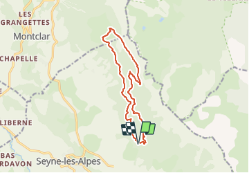
Randonnée Marche de 13,8 km à découvrir à Provence-Alpes-Côte d'Azur, Alpes-de-Haute-Provence, Seyne. Cette randonnée est proposée par Papige.
Description
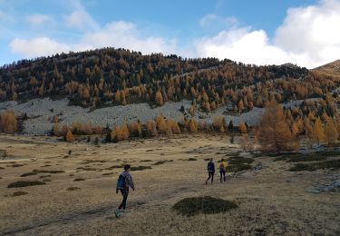
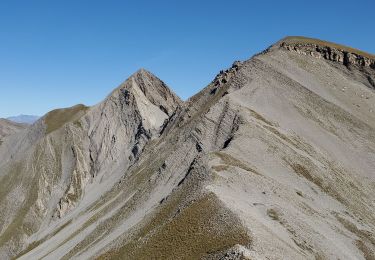
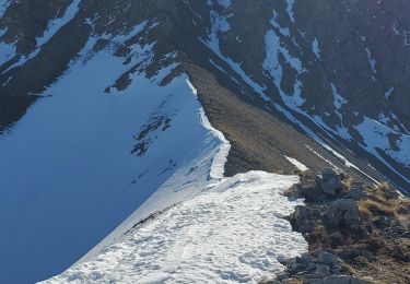
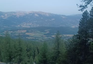
Départ du carrefour de Bellevue, sentier du GR, puis pistes jusqu’à la Chau. Retour par le sentier découverte puis pistes en passant par le clôt des Ayres.
Localisation
Pays :
France
Région :
Provence-Alpes-Côte d'Azur
Département/Province :
Alpes-de-Haute-Provence
Commune :
Seyne
Localité :
Unknown
Départ:(Dec)
Départ:(UTM)
292106 ; 4914991 (32T) N.
Commentaires
Randonnées à proximité
![Randonnée Marche Seyne - Dormillouse, lac noir et tourbières - Photo](https://media.geolcdn.com/t/375/260/ext.jpg?maxdim=2&url=https%3A%2F%2Fservices.sitytrail.com%2FGeolivesWS%2FDownloadMedia.ashx%3FTrailID%3D327459%26Media%3Df2c4c15e-e615-4934-adf1-ad96c650c8e6.JPG)
![Marche Marche](https://static1.geolcdn.com/sitytour/trail-icons/101.png)
Dormillouse, lac noir et tourbières
Marche
Moyen
(1)
Seyne,
Provence-Alpes-Côte d'Azur,
Alpes-de-Haute-Provence,
France
![](/images/other/stat-length.png)
12,7 km | 21 km-effort
4h 33min
![](https://static1.geolcdn.com/siteimages/upload/files/16400158638029165_repeat_loop_refresh_sync_direction_icon.png)
Oui
![Randonnée Marche Seyne - SEYNES LES ALPES . COL DE BERNARDES . PIC DE BERNARDES . PIC DE SAVERNES . COL BAS O N - Photo](https://media.geolcdn.com/t/375/260/b9753bd0-7cce-4d45-8b8c-6d083f8daf49.jpg&format=jpg&maxdim=2)
![Marche Marche](https://static1.geolcdn.com/sitytour/trail-icons/101.png)
SEYNES LES ALPES . COL DE BERNARDES . PIC DE BERNARDES . PIC DE SAVERNES . CO...
Marche
Difficile
Seyne,
Provence-Alpes-Côte d'Azur,
Alpes-de-Haute-Provence,
France
![](/images/other/stat-length.png)
10,4 km | 20 km-effort
3h 35min
![](https://static1.geolcdn.com/siteimages/upload/files/16400158638029165_repeat_loop_refresh_sync_direction_icon.png)
Oui
![Randonnée Marche Seyne - Dormillouse lac noir lac du milieu lac de la cabane - Photo](https://media.geolcdn.com/t/375/260/74e953cb-f434-450d-b6b9-3b41df759f06.jpg&format=jpg&maxdim=2)
![Marche Marche](https://static1.geolcdn.com/sitytour/trail-icons/101.png)
Dormillouse lac noir lac du milieu lac de la cabane
Marche
Facile
Seyne,
Provence-Alpes-Côte d'Azur,
Alpes-de-Haute-Provence,
France
![](/images/other/stat-length.png)
14,3 km | 25 km-effort
3h 26min
![](https://static1.geolcdn.com/siteimages/upload/files/16400158638029165_repeat_loop_refresh_sync_direction_icon.png)
Oui
![Randonnée Marche Seyne - SEYNES LES ALPES . Grand puy , montagne de la Blache , cabane du Mulet o l s - Photo](https://media.geolcdn.com/t/375/260/0a85776d-4fbe-44a9-8b16-bf4257f31cc2.jpg&format=jpg&maxdim=2)
![Marche Marche](https://static1.geolcdn.com/sitytour/trail-icons/101.png)
SEYNES LES ALPES . Grand puy , montagne de la Blache , cabane du Mulet o l s
Marche
Moyen
Seyne,
Provence-Alpes-Côte d'Azur,
Alpes-de-Haute-Provence,
France
![](/images/other/stat-length.png)
14,4 km | 23 km-effort
3h 57min
![](https://static1.geolcdn.com/siteimages/upload/files/16400158638029165_repeat_loop_refresh_sync_direction_icon.png)
Oui
![Randonnée Marche Seyne - Dormillouse en boucle par le lac du Milieu - Photo](https://media.geolcdn.com/t/375/260/00b187e0-1b72-43f3-8118-43ef927b2ae4.jpg&format=jpg&maxdim=2)
![Marche Marche](https://static1.geolcdn.com/sitytour/trail-icons/101.png)
Dormillouse en boucle par le lac du Milieu
Marche
Facile
Seyne,
Provence-Alpes-Côte d'Azur,
Alpes-de-Haute-Provence,
France
![](/images/other/stat-length.png)
13,1 km | 23 km-effort
4h 33min
![](https://static1.geolcdn.com/siteimages/upload/files/16400158638029165_repeat_loop_refresh_sync_direction_icon.png)
Oui
![Randonnée Marche Seyne - tour de tourtourel - Photo](https://media.geolcdn.com/t/375/260/ext.jpg?maxdim=2&url=https%3A%2F%2Fstatic1.geolcdn.com%2Fsiteimages%2Fupload%2Ffiles%2F1553511878bg_sport_marche.png)
![Marche Marche](https://static1.geolcdn.com/sitytour/trail-icons/101.png)
tour de tourtourel
Marche
Moyen
(2)
Seyne,
Provence-Alpes-Côte d'Azur,
Alpes-de-Haute-Provence,
France
![](/images/other/stat-length.png)
7,2 km | 13 km-effort
2h 37min
![](https://static1.geolcdn.com/siteimages/upload/files/16400158638029165_repeat_loop_refresh_sync_direction_icon.png)
Oui
![Randonnée Marche Seyne - dos de chameau 1165m 12kms - Photo](https://media.geolcdn.com/t/375/260/20594f73-6d6a-4dc1-92d9-8c17fbfc97a8.jpg&format=jpg&maxdim=2)
![Marche Marche](https://static1.geolcdn.com/sitytour/trail-icons/101.png)
dos de chameau 1165m 12kms
Marche
Moyen
Seyne,
Provence-Alpes-Côte d'Azur,
Alpes-de-Haute-Provence,
France
![](/images/other/stat-length.png)
10,8 km | 26 km-effort
8h 5min
![](https://static1.geolcdn.com/siteimages/upload/files/16400158638029165_repeat_loop_refresh_sync_direction_icon.png)
Oui
![Randonnée Marche Seyne - Seyne première bosse dos de chameau 9km 950m - Photo](https://media.geolcdn.com/t/375/260/5e0390cb-740a-4758-8977-417cce7cc0a2.jpg&format=jpg&maxdim=2)
![Marche Marche](https://static1.geolcdn.com/sitytour/trail-icons/101.png)
Seyne première bosse dos de chameau 9km 950m
Marche
Difficile
Seyne,
Provence-Alpes-Côte d'Azur,
Alpes-de-Haute-Provence,
France
![](/images/other/stat-length.png)
8,8 km | 21 km-effort
6h 40min
![](https://static1.geolcdn.com/siteimages/upload/files/16400158638029165_repeat_loop_refresh_sync_direction_icon.png)
Oui
![Randonnée Marche Seyne - SEYNES. COL BAS . LES 3 LACS . O L S - Photo](https://media.geolcdn.com/t/375/260/e5d2149b-e657-4daa-9fdc-ea2fd440ca92.jpg&format=jpg&maxdim=2)
![Marche Marche](https://static1.geolcdn.com/sitytour/trail-icons/101.png)
SEYNES. COL BAS . LES 3 LACS . O L S
Marche
Moyen
Seyne,
Provence-Alpes-Côte d'Azur,
Alpes-de-Haute-Provence,
France
![](/images/other/stat-length.png)
11,8 km | 17,6 km-effort
3h 24min
![](https://static1.geolcdn.com/siteimages/upload/files/16400158638029165_repeat_loop_refresh_sync_direction_icon.png)
Oui