![](/images/other/stat-length.png)
![Randonnée Vélo Saint-Martin-de-Castillon - La Véloroute - Voie Verte du Calavon - Photo](https://media.geolcdn.com/t/1900/400/ext.pjpeg?maxdim=2&url=https%3A%2F%2Fservices.sitytrail.com%2FGeolivesWS%2FDownloadMedia.ashx%3FTrailID%3D375432%26Media%3D492bf258-2a21-4a95-9687-f1dbf28d9a2a.jpg)
La Véloroute - Voie Verte du Calavon
Vélo Loisir Provence
Randonnées de Vélo Loisir Provence GUIDE+
![Longueur](/images/other/stat-length.png)
![Altitude max](https://static1.geolcdn.com/siteimages/upload/files/1508320355ic_sort_altitude_max_24dp.png)
![Dénivelé positif](https://static1.geolcdn.com/siteimages/upload/files/1508320355ic_sort_den_pos_24dp.png)
![Km-Effort](/images/other/stat-length.png)
![Altitude min](https://static1.geolcdn.com/siteimages/upload/files/1508320355ic_sort_altitude_min_24dp.png)
![Dénivelé négatif](https://static1.geolcdn.com/siteimages/upload/files/1508320355ic_sort_den_neg_24dp.png)
![Boucle](https://static1.geolcdn.com/siteimages/upload/files/16400158638029165_repeat_loop_refresh_sync_direction_icon.png)
![Balise](https://services.sitytrail.com/GeolivesWS/DownloadMedia.ashx?TrailID=375432&Media=balise.png)
![Vélo](https://static1.geolcdn.com/sitytour/trail-icons/200.png)
2h05
Difficulté : Facile
![Scannez ce code QR pour ouvrir la randonnée dans l'application SityTrail](https://capi.geolives.com/qq0zvz2zws4bq2lad0pu/sitytour/trails/375432/qr.png?size=200)
Application GPS de randonnée GRATUITE
À propos
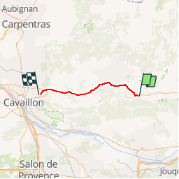
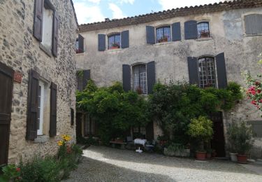
Randonnée Vélo de 37 km à découvrir à Provence-Alpes-Côte d'Azur, Vaucluse, Saint-Martin-de-Castillon. Cette randonnée est proposée par Vélo Loisir Provence.
Description
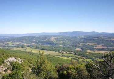
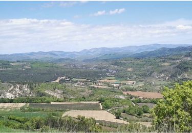
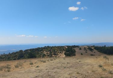
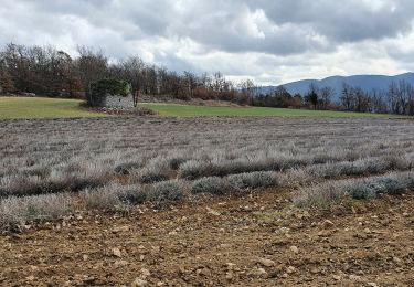
La balade familiale incontournable, sans voiture et sans dénivelé ! Cet itinéraire utilise, sur la plupart du parcours, l'emprise de l'ancienne voie ferrée Cavaillon-Apt-Volx. Elle emprunte une Voie verte sur une grande majorité, sauf sur 2 km au lieu dit 'Le Chêne' et pendant 500 m aux villages des Beaumettes et de Coustellet. La Véloroute commence au village de Robion, puis suit la vallée du Calavon, et s'achève au pied du Luberon, à la D 48 qui mène à Castellet. Le parcours est agréable, avec un pont romain, la traversée d'Apt en sécurité (viaducs et belles vues) et des paysages qui deviennent de plus en plus beaux : bords du Calavon, pentes du Luberon et ses villages perchés. Le circuit Autour du Luberon prend le relais, une fois arrivé au bout de cet itinéraire linéraire.
Localisation
Commentaires
Randonnées à proximité
![Randonnée Marche Auribeau - Le Mourre Nègre - Photo](https://media.geolcdn.com/t/375/260/ext.jpg?maxdim=2&url=https%3A%2F%2Fstatic1.geolcdn.com%2Fsiteimages%2Fupload%2Ffiles%2F1553511878bg_sport_marche.png)
![Marche Marche](https://static1.geolcdn.com/sitytour/trail-icons/101.png)
Marche
![](/images/other/stat-length.png)
![](https://static1.geolcdn.com/siteimages/upload/files/16400158638029165_repeat_loop_refresh_sync_direction_icon.png)
![Randonnée Marche Auribeau - Auribeau Mourre Négre retour Auribeau - Photo](https://media.geolcdn.com/t/375/260/a5950379-bfff-488c-9748-ecf51b9bfe23.jpg&format=jpg&maxdim=2)
![Marche Marche](https://static1.geolcdn.com/sitytour/trail-icons/101.png)
Marche
![](/images/other/stat-length.png)
![](https://static1.geolcdn.com/siteimages/upload/files/16400158638029165_repeat_loop_refresh_sync_direction_icon.png)
![Randonnée Marche Castellet-en-Luberon - Mourre du Grd Lubéron, crêtes et versant Nord - Photo](https://media.geolcdn.com/t/375/260/301a589c-0eae-4b76-b7e7-f2beafbfa250.jpg&format=jpg&maxdim=2)
![Marche Marche](https://static1.geolcdn.com/sitytour/trail-icons/101.png)
Marche
![](/images/other/stat-length.png)
![](https://static1.geolcdn.com/siteimages/upload/files/16400158638029165_repeat_loop_refresh_sync_direction_icon.png)
![Randonnée Marche Saint-Martin-de-Castillon - Saint Martin de Castillon ... Viens - Photo](https://media.geolcdn.com/t/375/260/f5954e86-11dc-4277-8586-d3c42a2e7a55.jpg&format=jpg&maxdim=2)
![Marche Marche](https://static1.geolcdn.com/sitytour/trail-icons/101.png)
Marche
![](/images/other/stat-length.png)
![](https://static1.geolcdn.com/siteimages/upload/files/16400158638029165_repeat_loop_refresh_sync_direction_icon.png)
![Randonnée Marche Auribeau - Auribeau. Mourre-Nègre - Photo](https://media.geolcdn.com/t/375/260/5a35ebf4-91df-4555-a784-dbaa73f02eb9.jpg&format=jpg&maxdim=2)
![Marche Marche](https://static1.geolcdn.com/sitytour/trail-icons/101.png)
Marche
![](/images/other/stat-length.png)
![](https://static1.geolcdn.com/siteimages/upload/files/16400158638029165_repeat_loop_refresh_sync_direction_icon.png)
![Randonnée Marche Auribeau - Moure Negre - Photo](https://media.geolcdn.com/t/375/260/becff8d0-1777-4ae0-99e1-058e990cfbe2.jpg&format=jpg&maxdim=2)
![Marche Marche](https://static1.geolcdn.com/sitytour/trail-icons/101.png)
Marche
![](/images/other/stat-length.png)
![](https://static1.geolcdn.com/siteimages/upload/files/16400158638029165_repeat_loop_refresh_sync_direction_icon.png)
![Randonnée Marche Castellet-en-Luberon - St Martin de Castillon - Caseneuve - Photo](https://media.geolcdn.com/t/375/260/e3e858ef-987c-42e0-9cfc-e9567aa06a01.jpg&format=jpg&maxdim=2)
![Marche Marche](https://static1.geolcdn.com/sitytour/trail-icons/101.png)
Marche
![](/images/other/stat-length.png)
![](https://static1.geolcdn.com/siteimages/upload/files/16400158638029165_repeat_loop_refresh_sync_direction_icon.png)
![V.T.T. V.T.T.](https://static1.geolcdn.com/sitytour/trail-icons/202.png)
V.T.T.
![](/images/other/stat-length.png)
![](https://static1.geolcdn.com/siteimages/upload/files/16400158638029165_repeat_loop_refresh_sync_direction_icon.png)
![Randonnée Marche Auribeau - auribeau - Photo](https://media.geolcdn.com/t/375/260/324db42c-4d31-4935-a471-7d40beb7a7a2.jpg&format=jpg&maxdim=2)
![Marche Marche](https://static1.geolcdn.com/sitytour/trail-icons/101.png)
Marche
![](/images/other/stat-length.png)
![](https://static1.geolcdn.com/siteimages/upload/files/16400158638029165_repeat_loop_refresh_sync_direction_icon.png)