![](/images/other/stat-length.png)
SAINT-MARTIN-D'ARBEROUE 500m.
DECHAMPD
Utilisateur
![Longueur](/images/other/stat-length.png)
Longueur
10,9 km
![Altitude max](https://static1.geolcdn.com/siteimages/upload/files/1508320355ic_sort_altitude_max_24dp.png)
Altitude max
412 m
![Dénivelé positif](https://static1.geolcdn.com/siteimages/upload/files/1508320355ic_sort_den_pos_24dp.png)
Dénivelé positif
492 m
![Km-Effort](/images/other/stat-length.png)
Km-Effort
17,4 km
![Altitude min](https://static1.geolcdn.com/siteimages/upload/files/1508320355ic_sort_altitude_min_24dp.png)
Altitude min
120 m
![Dénivelé négatif](https://static1.geolcdn.com/siteimages/upload/files/1508320355ic_sort_den_neg_24dp.png)
Dénivelé négatif
491 m
![Boucle](https://static1.geolcdn.com/siteimages/upload/files/16400158638029165_repeat_loop_refresh_sync_direction_icon.png)
Boucle
Oui
Date de création :
2019-01-14 17:34:48.261
Dernière modification :
2021-03-11 16:21:12.397
![Marche](https://static1.geolcdn.com/sitytour/trail-icons/101.png)
3h37
Difficulté : Moyen
![Scannez ce code QR pour ouvrir la randonnée dans l'application SityTrail](https://capi.geolives.com/qq0zvz2zws4bq2lad0pu/sitytour/trails/375310/qr.png?size=200)
Application GPS de randonnée GRATUITE
À propos
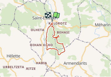
Randonnée Marche de 10,9 km à découvrir à Nouvelle-Aquitaine, Pyrénées-Atlantiques, Saint-Martin-d'Arberoue. Cette randonnée est proposée par DECHAMPD.
Description
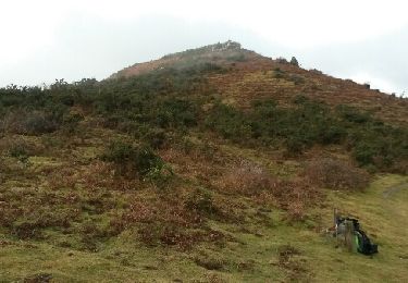
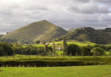
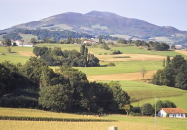
départ sortie St Estebe (garage) D14.Carricaburua sommet de l'Eltzarruze 421m, puis vallée jusqu'à Etchartéa, Chichabalé, col Herauzeko, descente vers réservoir, Uhaldégaraya, Ithurburukoborda,suivre chemin. effectué le 06/01/2015
Points d'intérêt
Localisation
Pays :
France
Région :
Nouvelle-Aquitaine
Département/Province :
Pyrénées-Atlantiques
Commune :
Saint-Martin-d'Arberoue
Localité :
Unknown
Départ:(Dec)
Départ:(UTM)
645853 ; 4799671 (30T) N.
Commentaires
Randonnées à proximité
![Randonnée Cheval Hélette - Hélette - St Martin d'Arbéroue - Photo](https://media.geolcdn.com/t/375/260/ext.jpg?maxdim=2&url=https%3A%2F%2Fservices.sitytrail.com%2FGeolivesWS%2FDownloadMedia.ashx%3FTrailID%3D129950%26Media%3D13508_4.jpg)
![Cheval Cheval](https://static1.geolcdn.com/sitytour/trail-icons/300.png)
Hélette - St Martin d'Arbéroue
Cheval
Difficile
Hélette,
Nouvelle-Aquitaine,
Pyrénées-Atlantiques,
France
![](/images/other/stat-length.png)
15,6 km | 22 km-effort
3h 0min
![](https://static1.geolcdn.com/siteimages/upload/files/16400158638029165_repeat_loop_refresh_sync_direction_icon.png)
Non
![Randonnée Marche Hélette - Hélette Soylandotchipi - Photo](https://media.geolcdn.com/t/375/260/ext.jpg?maxdim=2&url=https%3A%2F%2Fservices.sitytrail.com%2FGeolivesWS%2FDownloadMedia.ashx%3FTrailID%3D381338%26Media%3Dfix__20150128123706.jpg)
![Marche Marche](https://static1.geolcdn.com/sitytour/trail-icons/101.png)
Hélette Soylandotchipi
Marche
Moyen
Hélette,
Nouvelle-Aquitaine,
Pyrénées-Atlantiques,
France
![](/images/other/stat-length.png)
14 km | 22 km-effort
4h 28min
![](https://static1.geolcdn.com/siteimages/upload/files/16400158638029165_repeat_loop_refresh_sync_direction_icon.png)
Oui
![Randonnée Marche Saint-Martin-d'Arberoue - St ESTEBEN vallée de l'Arbéroue inv 500 - Photo](https://media.geolcdn.com/t/375/260/ext.jpg?maxdim=2&url=https%3A%2F%2Fservices.sitytrail.com%2FGeolivesWS%2FDownloadMedia.ashx%3FTrailID%3D374933%26Media%3D4adfb92d-a52c-46d8-b76a-c401946aacf8.JPG)
![Marche Marche](https://static1.geolcdn.com/sitytour/trail-icons/101.png)
St ESTEBEN vallée de l'Arbéroue inv 500
Marche
Moyen
Saint-Martin-d'Arberoue,
Nouvelle-Aquitaine,
Pyrénées-Atlantiques,
France
![](/images/other/stat-length.png)
10,9 km | 17,4 km-effort
3h 38min
![](https://static1.geolcdn.com/siteimages/upload/files/16400158638029165_repeat_loop_refresh_sync_direction_icon.png)
Oui
![Randonnée Marche Saint-Martin-d'Arberoue - AAA Belekarre - St Martin d'Arbéroue 400m. - Photo](https://media.geolcdn.com/t/375/260/ext.jpg?maxdim=2&url=https%3A%2F%2Fservices.sitytrail.com%2FGeolivesWS%2FDownloadMedia.ashx%3FTrailID%3D357711%26Media%3D4dcabf91-01f9-431c-b1b6-774797166aec.jpg)
![Marche Marche](https://static1.geolcdn.com/sitytour/trail-icons/101.png)
AAA Belekarre - St Martin d'Arbéroue 400m.
Marche
Moyen
Saint-Martin-d'Arberoue,
Nouvelle-Aquitaine,
Pyrénées-Atlantiques,
France
![](/images/other/stat-length.png)
8 km | 12,8 km-effort
2h 44min
![](https://static1.geolcdn.com/siteimages/upload/files/16400158638029165_repeat_loop_refresh_sync_direction_icon.png)
Oui
![Randonnée Marche Saint-Martin-d'Arberoue - Belekarre - St Martin d'Arbéroue 325m. - Photo](https://media.geolcdn.com/t/375/260/ext.jpg?maxdim=2&url=https%3A%2F%2Fservices.sitytrail.com%2FGeolivesWS%2FDownloadMedia.ashx%3FTrailID%3D357525%26Media%3D4dcabf91-01f9-431c-b1b6-774797166aec.jpg)
![Marche Marche](https://static1.geolcdn.com/sitytour/trail-icons/101.png)
Belekarre - St Martin d'Arbéroue 325m.
Marche
Moyen
Saint-Martin-d'Arberoue,
Nouvelle-Aquitaine,
Pyrénées-Atlantiques,
France
![](/images/other/stat-length.png)
9,5 km | 13,7 km-effort
2h 54min
![](https://static1.geolcdn.com/siteimages/upload/files/16400158638029165_repeat_loop_refresh_sync_direction_icon.png)
Oui
![Randonnée Cheval Saint-Martin-d'Arberoue - St Martin d'Arbéroue - Pessarou - Photo](https://media.geolcdn.com/t/375/260/ext.jpg?maxdim=2&url=https%3A%2F%2Fservices.sitytrail.com%2FGeolivesWS%2FDownloadMedia.ashx%3FTrailID%3D129951%26Media%3D13509_2.jpg)
![Cheval Cheval](https://static1.geolcdn.com/sitytour/trail-icons/300.png)
St Martin d'Arbéroue - Pessarou
Cheval
Difficile
Saint-Martin-d'Arberoue,
Nouvelle-Aquitaine,
Pyrénées-Atlantiques,
France
![](/images/other/stat-length.png)
18,7 km | 24 km-effort
3h 0min
![](https://static1.geolcdn.com/siteimages/upload/files/16400158638029165_repeat_loop_refresh_sync_direction_icon.png)
Non
![Randonnée Marche Saint-Martin-d'Arberoue - Belekarre - St Martin d'Arbéroue - Photo](https://media.geolcdn.com/t/375/260/ext.jpg?maxdim=2&url=https%3A%2F%2Fservices.sitytrail.com%2FGeolivesWS%2FDownloadMedia.ashx%3FTrailID%3D111954%26Media%3D9137_1.jpg)
![Marche Marche](https://static1.geolcdn.com/sitytour/trail-icons/101.png)
Belekarre - St Martin d'Arbéroue
Marche
Moyen
(1)
Saint-Martin-d'Arberoue,
Nouvelle-Aquitaine,
Pyrénées-Atlantiques,
France
![](/images/other/stat-length.png)
5,2 km | 7,6 km-effort
2h 15min
![](https://static1.geolcdn.com/siteimages/upload/files/16400158638029165_repeat_loop_refresh_sync_direction_icon.png)
Oui
![Randonnée Marche Hélette - pic de Garralda - Photo](https://media.geolcdn.com/t/375/260/ext.jpg?maxdim=2&url=https%3A%2F%2Fstatic1.geolcdn.com%2Fsiteimages%2Fupload%2Ffiles%2F1553511878bg_sport_marche.png)
![Marche Marche](https://static1.geolcdn.com/sitytour/trail-icons/101.png)
pic de Garralda
Marche
Très facile
Hélette,
Nouvelle-Aquitaine,
Pyrénées-Atlantiques,
France
![](/images/other/stat-length.png)
5 km | 7,4 km-effort
3h 19min
![](https://static1.geolcdn.com/siteimages/upload/files/16400158638029165_repeat_loop_refresh_sync_direction_icon.png)
Oui
![Randonnée Marche Saint-Martin-d'Arberoue - Eltzarrueko Itzulia (Tour de l'Eltzarruze) - Photo](https://media.geolcdn.com/t/375/260/ext.jpg?maxdim=2&url=https%3A%2F%2Fstatic1.geolcdn.com%2Fsiteimages%2Fupload%2Ffiles%2F1553511878bg_sport_marche.png)
![Marche Marche](https://static1.geolcdn.com/sitytour/trail-icons/101.png)
Eltzarrueko Itzulia (Tour de l'Eltzarruze)
Marche
Moyen
Saint-Martin-d'Arberoue,
Nouvelle-Aquitaine,
Pyrénées-Atlantiques,
France
![](/images/other/stat-length.png)
12,5 km | 18,1 km-effort
3h 53min
![](https://static1.geolcdn.com/siteimages/upload/files/16400158638029165_repeat_loop_refresh_sync_direction_icon.png)
Oui