Randonnée V.T.T. Mallnitz - Mallnotzhutte - Photo
 ajpbm
ajpbm

Utilisateur

© OpenStreetMap contributors
Longueur
Longueur
36 km
Altitude max
Altitude max
1827 m
Dénivelé positif
Dénivelé positif
945 m
Km-Effort
Km-Effort  
50 km
Altitude min
Altitude min
665 m
Dénivelé négatif
Dénivelé négatif
1424 m
Boucle
Boucle
Non
Date de création :
2023-07-26 11:32:48.607
Dernière modification :
2023-07-26 15:34:05.821

(0 Avis)

V.T.T.
V.T.T.
3h59
Difficulté : Moyen

Scannez ce code QR pour ouvrir la randonnée dans l'application SityTrail

Application GPS de randonnée GRATUITE

Logo SityTrail SityTrail

IGN / Instituts géographiques

Télécharger SityTrail sur l'App Store Télécharger SityTrail sur Google Play

Logo SityTrail SityTrail World

Le monde est à vous

Télécharger SityTrail sur l'App Store Télécharger SityTrail sur Google Play Télécharger SityTrail sur Huawei AppGallery

À propos

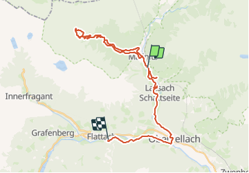
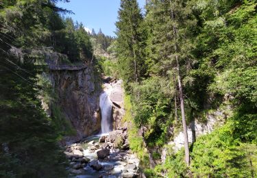
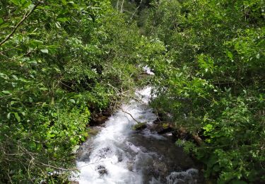
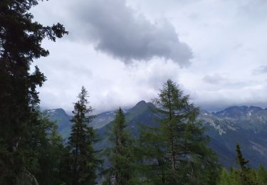
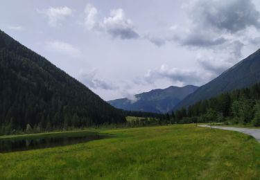
Randonnée V.T.T. de 36 km à découvrir à Carinthie, Bezirk Spittal an der Drau, Mallnitz. Cette randonnée est proposée par ajpbm.

Profil altimétrique

Localisation

Pays :
Autriche
Région :
Carinthie
Département/Province :
Bezirk Spittal an der Drau
Commune :
Mallnitz
Localité :
Unknown
Départ:(UTM)
361233 ; 5204673 (33T) N.

Randonnées à proximité

Randonnée A pied Mallnitz - Naturlehrweg Seebachtal - Stappitzer See - Photo
A pied
GUIDE+

A pied

Facile
Mallnitz, Carinthie, Bezirk Spittal an der Drau, Autriche
4,5 km | 5,6 km-effort
1h 17min
Non
Randonnée A pied Mallnitz - Kulturweg Römerstraßen (Niedere Tauern) - Photo
A pied
GUIDE+

A pied

Facile
Mallnitz, Carinthie, Bezirk Spittal an der Drau, Autriche
6,4 km | 14 km-effort
3h 10min
Non
Randonnée Marche Mallnitz - Ballade Auernig - Photo
Marche
edevuyst

Marche

Difficile
Mallnitz, Carinthie, Bezirk Spittal an der Drau, Autriche
5,3 km | 12,9 km-effort
3h 53min
Non
Randonnée Marche Mallnitz - Hagener Hutte - Photo
Marche
Arnaud Dejean

Marche

Difficile
Mallnitz, Carinthie, Bezirk Spittal an der Drau, Autriche
13,3 km | 25 km-effort
4h 45min
Oui
Randonnée Marche Obervellach - Groppensteinschlucht - Photo
Marche
Arnaud Dejean

Marche

Facile
Obervellach, Carinthie, Bezirk Spittal an der Drau, Autriche
4,6 km | 7,8 km-effort
1h 42min
Oui
Randonnée Marche Mallnitz - Dösener - Photo
Marche
Arnaud Dejean

Marche

Difficile
Mallnitz, Carinthie, Bezirk Spittal an der Drau, Autriche
15,6 km | 28 km-effort
4h 59min
Oui
Randonnée Marche Mallnitz - mallnitz - Photo
Marche
Arnaud Dejean

Marche

Moyen
Mallnitz, Carinthie, Bezirk Spittal an der Drau, Autriche
3,5 km | 11,7 km-effort
1h 33min
Oui
Randonnée Marche Mallnitz - Seebach Cascades - Photo
Marche
Arnaud Dejean

Marche

Très facile
Mallnitz, Carinthie, Bezirk Spittal an der Drau, Autriche
10,3 km | 12,3 km-effort
2h 19min
Oui
Randonnée Marche Mallnitz - Dösen tal - Photo
Marche
edevuyst

Marche

Facile
Mallnitz, Carinthie, Bezirk Spittal an der Drau, Autriche
2,7 km | 3,8 km-effort
43min
Non


Fermer
Mes abonnements