![](/images/other/stat-length.png)
![Randonnée Marche Vals-les-Bains - Vals-Coste d'haut-table d'orientation - Photo](https://media.geolcdn.com/t/1900/400/ext.pjpeg?maxdim=2&url=https%3A%2F%2Fstatic1.geolcdn.com%2Fsiteimages%2Fupload%2Ffiles%2F1553511878bg_sport_marche.png)
Vals-Coste d'haut-table d'orientation
coureursdecretes
Utilisateur
![Longueur](/images/other/stat-length.png)
Longueur
10,9 km
![Altitude max](https://static1.geolcdn.com/siteimages/upload/files/1508320355ic_sort_altitude_max_24dp.png)
Altitude max
472 m
![Dénivelé positif](https://static1.geolcdn.com/siteimages/upload/files/1508320355ic_sort_den_pos_24dp.png)
Dénivelé positif
392 m
![Km-Effort](/images/other/stat-length.png)
Km-Effort
16,1 km
![Altitude min](https://static1.geolcdn.com/siteimages/upload/files/1508320355ic_sort_altitude_min_24dp.png)
Altitude min
275 m
![Dénivelé négatif](https://static1.geolcdn.com/siteimages/upload/files/1508320355ic_sort_den_neg_24dp.png)
Dénivelé négatif
393 m
![Boucle](https://static1.geolcdn.com/siteimages/upload/files/16400158638029165_repeat_loop_refresh_sync_direction_icon.png)
Boucle
Oui
Date de création :
2023-07-24 07:00:47.93
Dernière modification :
2023-07-24 16:17:56.139
![Marche](https://static1.geolcdn.com/sitytour/trail-icons/101.png)
3h39
Difficulté : Difficile
![Scannez ce code QR pour ouvrir la randonnée dans l'application SityTrail](https://capi.geolives.com/qq0zvz2zws4bq2lad0pu/sitytour/trails/3745508/qr.png?size=200)
Application GPS de randonnée GRATUITE
À propos
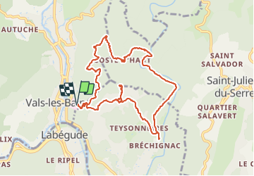
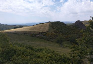
Randonnée Marche de 10,9 km à découvrir à Auvergne-Rhône-Alpes, Ardèche, Vals-les-Bains. Cette randonnée est proposée par coureursdecretes.
Description
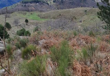
Pas de difficultés majeures. Pas mal en été car beaucoup de sentiers à couvert. Belle vue de la table d'orientation.
Localisation
Pays :
France
Région :
Auvergne-Rhône-Alpes
Département/Province :
Ardèche
Commune :
Vals-les-Bains
Localité :
Unknown
Départ:(Dec)
Départ:(UTM)
608671 ; 4945553 (31T) N.
Commentaires
Randonnées à proximité
![Randonnée Marche Lentillères - Lentillères-Les crêtes-Les hameaux - Photo](https://media.geolcdn.com/t/375/260/b26fd82a-80a8-4147-8d0f-0d41ac6326b3.jpg&format=jpg&maxdim=2)
![Marche Marche](https://static1.geolcdn.com/sitytour/trail-icons/101.png)
Lentillères-Les crêtes-Les hameaux
Marche
Très facile
(1)
Lentillères,
Auvergne-Rhône-Alpes,
Ardèche,
France
![](/images/other/stat-length.png)
12,2 km | 18,7 km-effort
3h 58min
![](https://static1.geolcdn.com/siteimages/upload/files/16400158638029165_repeat_loop_refresh_sync_direction_icon.png)
Oui
![Randonnée Marche Vals-les-Bains - 07 vals les bains 27.10.2022 - Photo](https://media.geolcdn.com/t/375/260/780fb152-cf3b-4bf0-9468-3f2a5cbe9d03.jpg&format=jpg&maxdim=2)
![Marche Marche](https://static1.geolcdn.com/sitytour/trail-icons/101.png)
07 vals les bains 27.10.2022
Marche
Facile
Vals-les-Bains,
Auvergne-Rhône-Alpes,
Ardèche,
France
![](/images/other/stat-length.png)
17,6 km | 29 km-effort
7h 24min
![](https://static1.geolcdn.com/siteimages/upload/files/16400158638029165_repeat_loop_refresh_sync_direction_icon.png)
Oui
![Randonnée Course à pied Saint-Michel-de-Boulogne - saint Michel de Boulogne - Photo](https://media.geolcdn.com/t/375/260/62a1acde-2372-46d5-896a-ffdc73b65bdd.jpg&format=jpg&maxdim=2)
![Course à pied Course à pied](https://static1.geolcdn.com/sitytour/trail-icons/103.png)
saint Michel de Boulogne
Course à pied
Moyen
Saint-Michel-de-Boulogne,
Auvergne-Rhône-Alpes,
Ardèche,
France
![](/images/other/stat-length.png)
12,3 km | 17 km-effort
1h 33min
![](https://static1.geolcdn.com/siteimages/upload/files/16400158638029165_repeat_loop_refresh_sync_direction_icon.png)
Non
![Randonnée Vélo de route Saint-Michel-de-Boulogne - Saint Joseph des bancs - Photo](https://media.geolcdn.com/t/375/260/350d6854-c630-4550-9cef-3634e2177ee4.jpg&format=jpg&maxdim=2)
![Vélo de route Vélo de route](https://static1.geolcdn.com/sitytour/trail-icons/201.png)
Saint Joseph des bancs
Vélo de route
Moyen
Saint-Michel-de-Boulogne,
Auvergne-Rhône-Alpes,
Ardèche,
France
![](/images/other/stat-length.png)
49 km | 64 km-effort
3h 24min
![](https://static1.geolcdn.com/siteimages/upload/files/16400158638029165_repeat_loop_refresh_sync_direction_icon.png)
Oui
![Randonnée Marche Vals-les-Bains - 07 vals les bains/ Sandron/ haut segur - Photo](https://media.geolcdn.com/t/375/260/216d479e-0463-4bcd-bc59-9c9ca3026231.jpg&format=jpg&maxdim=2)
![Marche Marche](https://static1.geolcdn.com/sitytour/trail-icons/101.png)
07 vals les bains/ Sandron/ haut segur
Marche
Moyen
Vals-les-Bains,
Auvergne-Rhône-Alpes,
Ardèche,
France
![](/images/other/stat-length.png)
18,8 km | 31 km-effort
7h 23min
![](https://static1.geolcdn.com/siteimages/upload/files/16400158638029165_repeat_loop_refresh_sync_direction_icon.png)
Oui
![Randonnée Marche Saint-Andéol-de-Vals - 07 st Andeol de vals - Photo](https://media.geolcdn.com/t/375/260/a317618f-c6db-4fe3-a756-43f4ecdf49ea.jpg&format=jpg&maxdim=2)
![Marche Marche](https://static1.geolcdn.com/sitytour/trail-icons/101.png)
07 st Andeol de vals
Marche
Facile
Saint-Andéol-de-Vals,
Auvergne-Rhône-Alpes,
Ardèche,
France
![](/images/other/stat-length.png)
15,3 km | 24 km-effort
6h 3min
![](https://static1.geolcdn.com/siteimages/upload/files/16400158638029165_repeat_loop_refresh_sync_direction_icon.png)
Oui
![Randonnée Marche Vals-les-Bains - Tesseaux - Photo](https://media.geolcdn.com/t/375/260/ext.jpg?maxdim=2&url=https%3A%2F%2Fstatic1.geolcdn.com%2Fsiteimages%2Fupload%2Ffiles%2F1553511878bg_sport_marche.png)
![Marche Marche](https://static1.geolcdn.com/sitytour/trail-icons/101.png)
Tesseaux
Marche
Facile
(1)
Vals-les-Bains,
Auvergne-Rhône-Alpes,
Ardèche,
France
![](/images/other/stat-length.png)
4 km | 5,7 km-effort
1h 13min
![](https://static1.geolcdn.com/siteimages/upload/files/16400158638029165_repeat_loop_refresh_sync_direction_icon.png)
Oui
![Randonnée Marche Lentillères - Crêtes de Lentilleres - Photo](https://media.geolcdn.com/t/375/260/2b107a6d-80b7-4b48-a6e0-d934a718f25e.jpg&format=jpg&maxdim=2)
![Marche Marche](https://static1.geolcdn.com/sitytour/trail-icons/101.png)
Crêtes de Lentilleres
Marche
Très facile
(1)
Lentillères,
Auvergne-Rhône-Alpes,
Ardèche,
France
![](/images/other/stat-length.png)
12,1 km | 18,9 km-effort
4h 52min
![](https://static1.geolcdn.com/siteimages/upload/files/16400158638029165_repeat_loop_refresh_sync_direction_icon.png)
Oui
![Randonnée Marche Prades - balade prades avec meyras - Photo](https://media.geolcdn.com/t/375/260/ext.jpg?maxdim=2&url=https%3A%2F%2Fstatic1.geolcdn.com%2Fsiteimages%2Fupload%2Ffiles%2F1553511878bg_sport_marche.png)
![Marche Marche](https://static1.geolcdn.com/sitytour/trail-icons/101.png)
balade prades avec meyras
Marche
Moyen
(1)
Prades,
Auvergne-Rhône-Alpes,
Ardèche,
France
![](/images/other/stat-length.png)
8,2 km | 11,1 km-effort
2h 14min
![](https://static1.geolcdn.com/siteimages/upload/files/16400158638029165_repeat_loop_refresh_sync_direction_icon.png)
Oui
un dénivelé court et un rythme régulier