![](/images/other/stat-length.png)
![Randonnée Marche Gorje - Gorges de Vintgard avec retour via Chapelle Sté Catherine - Photo](https://media.geolcdn.com/t/1900/400/ext.pjpeg?maxdim=2&url=https%3A%2F%2Fstatic1.geolcdn.com%2Fsiteimages%2Fupload%2Ffiles%2F1553511878bg_sport_marche.png)
Gorges de Vintgard avec retour via Chapelle Sté Catherine
JM Heine
Utilisateur
![Longueur](/images/other/stat-length.png)
Longueur
6,7 km
![Altitude max](https://static1.geolcdn.com/siteimages/upload/files/1508320355ic_sort_altitude_max_24dp.png)
Altitude max
650 m
![Dénivelé positif](https://static1.geolcdn.com/siteimages/upload/files/1508320355ic_sort_den_pos_24dp.png)
Dénivelé positif
225 m
![Km-Effort](/images/other/stat-length.png)
Km-Effort
9,7 km
![Altitude min](https://static1.geolcdn.com/siteimages/upload/files/1508320355ic_sort_altitude_min_24dp.png)
Altitude min
534 m
![Dénivelé négatif](https://static1.geolcdn.com/siteimages/upload/files/1508320355ic_sort_den_neg_24dp.png)
Dénivelé négatif
213 m
![Boucle](https://static1.geolcdn.com/siteimages/upload/files/16400158638029165_repeat_loop_refresh_sync_direction_icon.png)
Boucle
Non
Date de création :
2023-07-23 09:16:24.0
Dernière modification :
2023-07-23 12:11:59.13
![Marche](https://static1.geolcdn.com/sitytour/trail-icons/101.png)
2h53
Difficulté : Très facile
![Scannez ce code QR pour ouvrir la randonnée dans l'application SityTrail](https://capi.geolives.com/qq0zvz2zws4bq2lad0pu/sitytour/trails/3744341/qr.png?size=200)
Application GPS de randonnée GRATUITE
À propos
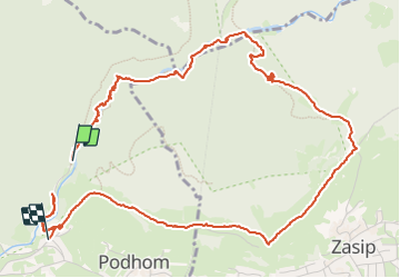
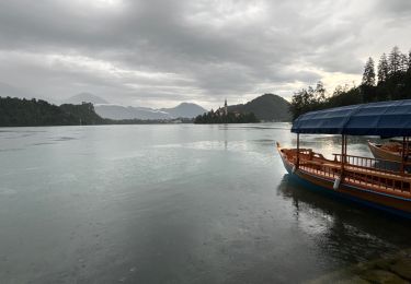
Randonnée Marche de 6,7 km à découvrir à Inconnu, Inconnu, Gorje. Cette randonnée est proposée par JM Heine.
Description
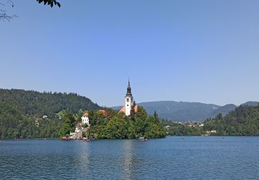
Incontournable à Bled !
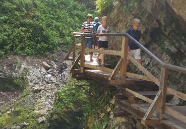
Voitures : se garer au P3 (7€/4h prix été 2023) d’où une navette gratuite vous emmène à l’entrée de ce magnifique site ! PPRENDRE LE TEMPS ET PROFITER !
Localisation
Pays :
Slovénie
Région :
Inconnu
Département/Province :
Inconnu
Commune :
Gorje
Localité :
Unknown
Départ:(Dec)
Départ:(UTM)
429724 ; 5138218 (33T) N.
Commentaires
Randonnées à proximité
![Randonnée A pied Bled - Wikiloc Bled Mala Osojnica (PVDB) - Photo](https://media.geolcdn.com/t/375/260/5472c15a-9830-4b7a-8188-652e48a7db96.jpg&format=jpg&maxdim=2)
![A pied A pied](https://static1.geolcdn.com/sitytour/trail-icons/100.png)
Wikiloc Bled Mala Osojnica (PVDB)
A pied
Difficile
Bled,
Inconnu,
Inconnu,
Slovénie
![](/images/other/stat-length.png)
3,7 km | 7,3 km-effort
2h 9min
![](https://static1.geolcdn.com/siteimages/upload/files/16400158638029165_repeat_loop_refresh_sync_direction_icon.png)
Oui
![Randonnée A pied Gorje - Wikiloc: Vintgar Sveta katerina (PVDB) - Photo](https://media.geolcdn.com/t/375/260/fad3346c-fc07-42b9-901d-ba3e1cd4ea00.jpg&format=jpg&maxdim=2)
![A pied A pied](https://static1.geolcdn.com/sitytour/trail-icons/100.png)
Wikiloc: Vintgar Sveta katerina (PVDB)
A pied
Facile
Gorje,
Inconnu,
Inconnu,
Slovénie
![](/images/other/stat-length.png)
5,7 km | 8,2 km-effort
1h 39min
![](https://static1.geolcdn.com/siteimages/upload/files/16400158638029165_repeat_loop_refresh_sync_direction_icon.png)
Oui
![Randonnée Marche Radovljica - 15-08-23 camping Sobec, lac de Bled, Mala Osojnica et retour - Photo](https://media.geolcdn.com/t/375/260/0c5a51d2-7444-4316-8e43-fb803da6fa14.jpg&format=jpg&maxdim=2)
![Marche Marche](https://static1.geolcdn.com/sitytour/trail-icons/101.png)
15-08-23 camping Sobec, lac de Bled, Mala Osojnica et retour
Marche
Difficile
Radovljica,
Inconnu,
Inconnu,
Slovénie
![](/images/other/stat-length.png)
19,1 km | 26 km-effort
6h 46min
![](https://static1.geolcdn.com/siteimages/upload/files/16400158638029165_repeat_loop_refresh_sync_direction_icon.png)
Oui
![Randonnée Marche Bled - Bled - Photo](https://media.geolcdn.com/t/375/260/8926e344-5357-44da-b547-de0b0b671a45.jpg&format=jpg&maxdim=2)
![Marche Marche](https://static1.geolcdn.com/sitytour/trail-icons/101.png)
![Randonnée Marche Gorje - Pokljuka - Photo](https://media.geolcdn.com/t/375/260/ext.jpg?maxdim=2&url=https%3A%2F%2Fstatic1.geolcdn.com%2Fsiteimages%2Fupload%2Ffiles%2F1553511878bg_sport_marche.png)
![Marche Marche](https://static1.geolcdn.com/sitytour/trail-icons/101.png)
![Randonnée Marche Bled - Gorges de vinegar - Photo](https://media.geolcdn.com/t/375/260/ext.jpg?maxdim=2&url=https%3A%2F%2Fstatic1.geolcdn.com%2Fsiteimages%2Fupload%2Ffiles%2F1553511878bg_sport_marche.png)
![Marche Marche](https://static1.geolcdn.com/sitytour/trail-icons/101.png)
Gorges de vinegar
Marche
Moyen
Bled,
Inconnu,
Inconnu,
Slovénie
![](/images/other/stat-length.png)
7,4 km | 10,8 km-effort
2h 20min
![](https://static1.geolcdn.com/siteimages/upload/files/16400158638029165_repeat_loop_refresh_sync_direction_icon.png)
Oui
![Randonnée Marche Bled - 2024-06-05 - Photo](https://media.geolcdn.com/t/375/260/ext.jpg?maxdim=2&url=https%3A%2F%2Fstatic1.geolcdn.com%2Fsiteimages%2Fupload%2Ffiles%2F1553511878bg_sport_marche.png)
![Marche Marche](https://static1.geolcdn.com/sitytour/trail-icons/101.png)
![Randonnée Marche Bled - retour gorges de Vintgar et forêt enchantée - Photo](https://media.geolcdn.com/t/375/260/ext.jpg?maxdim=2&url=https%3A%2F%2Fstatic1.geolcdn.com%2Fsiteimages%2Fupload%2Ffiles%2F1553511878bg_sport_marche.png)
![Marche Marche](https://static1.geolcdn.com/sitytour/trail-icons/101.png)
retour gorges de Vintgar et forêt enchantée
Marche
Moyen
Bled,
Inconnu,
Inconnu,
Slovénie
![](/images/other/stat-length.png)
5,9 km | 9 km-effort
2h 11min
![](https://static1.geolcdn.com/siteimages/upload/files/16400158638029165_repeat_loop_refresh_sync_direction_icon.png)
Non
![Randonnée sport Bled - routeyou-bled-rib-ev-laz-par-la-vallee - Photo](https://media.geolcdn.com/t/375/260/ext.jpg?maxdim=2&url=https%3A%2F%2Fsecurestorage.geolives.com%2Fsitytour%2Ftrail-bg%2Fdefault.jpg)
routeyou-bled-rib-ev-laz-par-la-vallee
sport
Très facile
Bled,
Inconnu,
Inconnu,
Slovénie
![](/images/other/stat-length.png)
28 km | 34 km-effort
Inconnu
![](https://static1.geolcdn.com/siteimages/upload/files/16400158638029165_repeat_loop_refresh_sync_direction_icon.png)
Non