eistobel SityTrail > Randonnées > Outdoor > Allemagne > Bavière > Landkreis Lindau > Grünenbach SityTrail > Randonnées > Outdoor > Allemagne > Bavière > Landkreis Lindau > Grünenbach eistobel jos.mergeay Utilisateur 3D © OpenStreetMap contributors Longueur 5,9 km Altitude max 758 m Dénivelé positif 146 m Km-Effort 7,8 km Altitude min 677 m Dénivelé négatif 144 m Boucle Non Date de création : 2023-07-04 13:00:39.956 Dernière modification : 2023-07-21 15:01:25.398 (0 Avis) Marche 2h12 Difficulté : Difficile Application GPS de randonnée GRATUITE SityTrail IGN / Instituts géographiques SityTrail World Le monde est à vous À propos Randonnée Marche de 5,9 km à découvrir à Bavière, Landkreis Lindau, Grünenbach. Cette randonnée est proposée par jos.mergeay. Légendes | Plus de détails (PDF) Profil altimétrique Légendes > 15% 15% - 10% 10% - 5% à plat 5% - 10% 10% - 15% 15% - 30% > 30% Photos Localisation Pays : Allemagne Région : Bavière Département/Province : Landkreis Lindau Commune : Grünenbach Localité : Unknown Départ:(Dec) 47.6401644 / 10.0235199 Départ:(UTM) 576879 ; 5276815 (32T) N. Commentaires Veuillez vous connecter pour laisser un commentaire ou une note Randonnées à proximité PRO Skulpturenweg Maierhöfen A pied Facile Maierhöfen, Bavière, Landkreis Lindau, Allemagne 
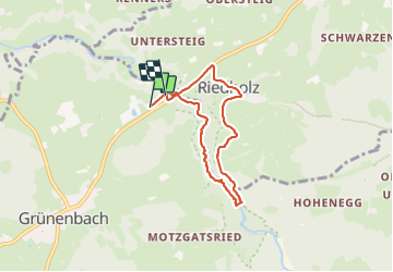
4,8 km | 6,4 km-effort 1h 27min Oui PRO Eistobel Rundweg Variante 2 A pied Facile Grünenbach, Bavière, Landkreis Lindau, Allemagne 3,2 km | 4,7 km-effort 1h 4min Non