![](/images/other/stat-length.png)
![Randonnée Marche Namur - LOYERS _Marche Fédérale _ NA _ 21/07/2023. - Photo](https://media.geolcdn.com/t/1900/400/bb4eaaee-fd86-4348-a2b4-b3c6b13ca002.jpg&format=pjpeg&maxdim=2)
LOYERS _Marche Fédérale _ NA _ 21/07/2023.
jeangulu
Utilisateur
![Longueur](/images/other/stat-length.png)
Longueur
21 km
![Altitude max](https://static1.geolcdn.com/siteimages/upload/files/1508320355ic_sort_altitude_max_24dp.png)
Altitude max
190 m
![Dénivelé positif](https://static1.geolcdn.com/siteimages/upload/files/1508320355ic_sort_den_pos_24dp.png)
Dénivelé positif
356 m
![Km-Effort](/images/other/stat-length.png)
Km-Effort
25 km
![Altitude min](https://static1.geolcdn.com/siteimages/upload/files/1508320355ic_sort_altitude_min_24dp.png)
Altitude min
69 m
![Dénivelé négatif](https://static1.geolcdn.com/siteimages/upload/files/1508320355ic_sort_den_neg_24dp.png)
Dénivelé négatif
356 m
![Boucle](https://static1.geolcdn.com/siteimages/upload/files/16400158638029165_repeat_loop_refresh_sync_direction_icon.png)
Boucle
Oui
Date de création :
2023-07-21 07:27:13.436
Dernière modification :
2023-07-21 12:30:41.336
![Marche](https://static1.geolcdn.com/sitytour/trail-icons/101.png)
5h02
Difficulté : Moyen
![Scannez ce code QR pour ouvrir la randonnée dans l'application SityTrail](https://capi.geolives.com/qq0zvz2zws4bq2lad0pu/sitytour/trails/3742185/qr.png?size=200)
Application GPS de randonnée GRATUITE
À propos
Randonnée Marche de 21 km à découvrir à Wallonie, Namur, Namur. Cette randonnée est proposée par jeangulu.
Description
Organisateur : NA 063 _ LES JOYEUX LURONS.
_3 ém Marche des LURONS.
Point de départ : Salle Jean XXII _ Rue de Maizeret 28 _ 5101 - LOYERS ( NAMUR )..
Carte IGN : 47/4
Localisation
Pays :
Belgique
Région :
Wallonie
Département/Province :
Namur
Commune :
Namur
Localité :
Unknown
Départ:(Dec)
Départ:(UTM)
638473 ; 5591943 (31U) N.
Commentaires
Randonnées à proximité
![Randonnée Marche Gesves - RB-Na-01_Faulx-les-Tombes_via-racc - Photo](https://media.geolcdn.com/t/375/260/ext.jpg?maxdim=2&url=https%3A%2F%2Fservices.sitytrail.com%2FGeolivesWS%2FDownloadMedia.ashx%3FTrailID%3D213609%26Media%3D506f23b2-0581-4f03-b006-9ca575596278.jpg)
![Marche Marche](https://static1.geolcdn.com/sitytour/trail-icons/101.png)
RB-Na-01_Faulx-les-Tombes_via-racc
Marche
Très difficile
(15)
Gesves,
Wallonie,
Namur,
Belgique
![](/images/other/stat-length.png)
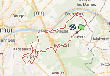
18,3 km | 25 km-effort
5h 34min
![](https://static1.geolcdn.com/siteimages/upload/files/16400158638029165_repeat_loop_refresh_sync_direction_icon.png)
Oui
![Randonnée Marche Gesves - RB-Na-01_Faulx-les-Tombes - Photo](https://media.geolcdn.com/t/375/260/ext.jpg?maxdim=2&url=https%3A%2F%2Fservices.sitytrail.com%2FGeolivesWS%2FDownloadMedia.ashx%3FTrailID%3D179626%26Media%3D506f23b2-0581-4f03-b006-9ca575596278.jpg)
![Marche Marche](https://static1.geolcdn.com/sitytour/trail-icons/101.png)
RB-Na-01_Faulx-les-Tombes
Marche
Très difficile
(15)
Gesves,
Wallonie,
Namur,
Belgique
![](/images/other/stat-length.png)
25 km | 33 km-effort
7h 26min
![](https://static1.geolcdn.com/siteimages/upload/files/16400158638029165_repeat_loop_refresh_sync_direction_icon.png)
Oui
![Randonnée Marche Gesves - GESVES -Mozet- N°06- Biodiversité - Photo](https://media.geolcdn.com/t/375/260/ext.jpg?maxdim=2&url=https%3A%2F%2Fservices.sitytrail.com%2FGeolivesWS%2FDownloadMedia.ashx%3FTrailID%3D121400%26Media%3D865b88e1-90ed-4454-a365-7e82ed8502df.JPG)
![Marche Marche](https://static1.geolcdn.com/sitytour/trail-icons/101.png)
GESVES -Mozet- N°06- Biodiversité
Marche
Facile
(10)
Gesves,
Wallonie,
Namur,
Belgique
![](/images/other/stat-length.png)
6,3 km | 7,8 km-effort
1h 41min
![](https://static1.geolcdn.com/siteimages/upload/files/16400158638029165_repeat_loop_refresh_sync_direction_icon.png)
Oui
![Randonnée Marche Andenne - La Vadrouille des Castors - Photo](https://media.geolcdn.com/t/375/260/ext.jpg?maxdim=2&url=https%3A%2F%2Fservices.sitytrail.com%2FGeolivesWS%2FDownloadMedia.ashx%3FTrailID%3D272035%26Media%3D1f2a432f-27e3-4b07-a115-5648fc3f71b1.jpg)
![Marche Marche](https://static1.geolcdn.com/sitytour/trail-icons/101.png)
La Vadrouille des Castors
Marche
Facile
(5)
Andenne,
Wallonie,
Namur,
Belgique
![](/images/other/stat-length.png)
3,6 km | 4,8 km-effort
1h 0min
![](https://static1.geolcdn.com/siteimages/upload/files/16400158638029165_repeat_loop_refresh_sync_direction_icon.png)
Oui
![Randonnée Marche Gesves - RF-Na-03-Goyet_Grande-boucle - Photo](https://media.geolcdn.com/t/375/260/ext.jpg?maxdim=2&url=https%3A%2F%2Fservices.sitytrail.com%2FGeolivesWS%2FDownloadMedia.ashx%3FTrailID%3D545745%26Media%3D72077e8d-e20a-4ee7-98f3-ad34263963e3.JPG)
![Marche Marche](https://static1.geolcdn.com/sitytour/trail-icons/101.png)
RF-Na-03-Goyet_Grande-boucle
Marche
Moyen
(5)
Gesves,
Wallonie,
Namur,
Belgique
![](/images/other/stat-length.png)
6,4 km | 8,9 km-effort
1h 54min
![](https://static1.geolcdn.com/siteimages/upload/files/16400158638029165_repeat_loop_refresh_sync_direction_icon.png)
Oui
![Randonnée Marche Namur - De Naninne vers Dave par les Fonds de Lustin et les Bois d'Acremont - Photo](https://media.geolcdn.com/t/375/260/ext.jpg?maxdim=2&url=https%3A%2F%2Fstatic1.geolcdn.com%2Fsiteimages%2Fupload%2Ffiles%2F1553511878bg_sport_marche.png)
![Marche Marche](https://static1.geolcdn.com/sitytour/trail-icons/101.png)
De Naninne vers Dave par les Fonds de Lustin et les Bois d'Acremont
Marche
Moyen
(5)
Namur,
Wallonie,
Namur,
Belgique
![](/images/other/stat-length.png)
19 km | 25 km-effort
5h 0min
![](https://static1.geolcdn.com/siteimages/upload/files/16400158638029165_repeat_loop_refresh_sync_direction_icon.png)
Oui
![Randonnée Marche Namur - Wartet - Marche-les-Dames_1499 - Photo](https://media.geolcdn.com/t/375/260/aa135fd6-2757-4c70-b0e7-24fa2425e5b7.jpg&format=jpg&maxdim=2)
![Marche Marche](https://static1.geolcdn.com/sitytour/trail-icons/101.png)
Wartet - Marche-les-Dames_1499
Marche
Difficile
(2)
Namur,
Wallonie,
Namur,
Belgique
![](/images/other/stat-length.png)
14,2 km | 19,5 km-effort
4h 25min
![](https://static1.geolcdn.com/siteimages/upload/files/16400158638029165_repeat_loop_refresh_sync_direction_icon.png)
Oui
![Randonnée Marche Namur - De Boninne aux Rochers de Marche-les-Dames - Photo](https://media.geolcdn.com/t/375/260/ext.jpg?maxdim=2&url=https%3A%2F%2Fservices.sitytrail.com%2FGeolivesWS%2FDownloadMedia.ashx%3FTrailID%3D1000620%26Media%3D20180707135425.jpg)
![Marche Marche](https://static1.geolcdn.com/sitytour/trail-icons/101.png)
De Boninne aux Rochers de Marche-les-Dames
Marche
Facile
(1)
Namur,
Wallonie,
Namur,
Belgique
![](/images/other/stat-length.png)
10,8 km | 14,6 km-effort
3h 5min
![](https://static1.geolcdn.com/siteimages/upload/files/16400158638029165_repeat_loop_refresh_sync_direction_icon.png)
Oui
![Randonnée Marche Andenne - Promenade Vezin - Photo](https://media.geolcdn.com/t/375/260/ext.jpg?maxdim=2&url=https%3A%2F%2Fservices.sitytrail.com%2FGeolivesWS%2FDownloadMedia.ashx%3FTrailID%3D272051%26Media%3D7b3740db-ce8a-4aa7-b1b1-8534b8413501.jpg)
![Marche Marche](https://static1.geolcdn.com/sitytour/trail-icons/101.png)
Promenade Vezin
Marche
Facile
(1)
Andenne,
Wallonie,
Namur,
Belgique
![](/images/other/stat-length.png)
6,1 km | 7,8 km-effort
1h 30min
![](https://static1.geolcdn.com/siteimages/upload/files/16400158638029165_repeat_loop_refresh_sync_direction_icon.png)
Non