![](/images/other/stat-length.png)
![Randonnée Marche Paris - DP75-36 De Porte-Dorée à Porte de Montreuil - Photo](https://media.geolcdn.com/t/1900/400/e41926ac-cecb-4a14-9088-307cd53b3b5e.jpg&format=pjpeg&maxdim=2)
DP75-36 De Porte-Dorée à Porte de Montreuil
clalaur
Utilisateur
![Longueur](/images/other/stat-length.png)
Longueur
4,3 km
![Altitude max](https://static1.geolcdn.com/siteimages/upload/files/1508320355ic_sort_altitude_max_24dp.png)
Altitude max
65 m
![Dénivelé positif](https://static1.geolcdn.com/siteimages/upload/files/1508320355ic_sort_den_pos_24dp.png)
Dénivelé positif
55 m
![Km-Effort](/images/other/stat-length.png)
Km-Effort
4,9 km
![Altitude min](https://static1.geolcdn.com/siteimages/upload/files/1508320355ic_sort_altitude_min_24dp.png)
Altitude min
39 m
![Dénivelé négatif](https://static1.geolcdn.com/siteimages/upload/files/1508320355ic_sort_den_neg_24dp.png)
Dénivelé négatif
39 m
![Boucle](https://static1.geolcdn.com/siteimages/upload/files/16400158638029165_repeat_loop_refresh_sync_direction_icon.png)
Boucle
Non
Date de création :
2023-07-20 16:11:18.727
Dernière modification :
2024-06-22 16:48:17.136
![Marche](https://static1.geolcdn.com/sitytour/trail-icons/101.png)
1h07
Difficulté : Facile
![Scannez ce code QR pour ouvrir la randonnée dans l'application SityTrail](https://capi.geolives.com/qq0zvz2zws4bq2lad0pu/sitytour/trails/3741338/qr.png?size=200)
Application GPS de randonnée GRATUITE
À propos
Randonnée Marche de 4,3 km à découvrir à Île-de-France, Paris, Paris. Cette randonnée est proposée par clalaur.
Description
Balade faite le vendredi 14 juin 2024.
Points forts : Chez Courteline, l'ancien emplacement d'une guillotine, Le triomphe de la République de Dalou, la rue d'Avon.
Localisation
Pays :
France
Région :
Île-de-France
Département/Province :
Paris
Commune :
Paris
Localité :
Paris 12e Arrondissement
Départ:(Dec)
Départ:(UTM)
456445 ; 5409314 (31U) N.
Commentaires
Randonnées à proximité
![Randonnée Marche Paris - Rando à thème : Georges Brassens - Parcours complet - Photo](https://media.geolcdn.com/t/375/260/dd7b2106-cdfc-45d2-b882-21cd74d02774.jpg&format=jpg&maxdim=2)
![Marche Marche](https://static1.geolcdn.com/sitytour/trail-icons/101.png)
Rando à thème : Georges Brassens - Parcours complet
Marche
Difficile
(1)
Paris,
Île-de-France,
Paris,
France
![](/images/other/stat-length.png)
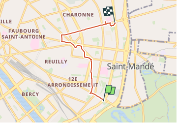
34 km | 39 km-effort
6h 49min
![](https://static1.geolcdn.com/siteimages/upload/files/16400158638029165_repeat_loop_refresh_sync_direction_icon.png)
Non
![Randonnée Marche Paris - Balade Paris Mars - Street art 13 ème / Tours Novel / Mouffetard---> Montorgueil - Photo](https://media.geolcdn.com/t/375/260/f8997d8c-ff6a-4865-a3fa-0c8ffc9300f3.jpg&format=jpg&maxdim=2)
![Marche Marche](https://static1.geolcdn.com/sitytour/trail-icons/101.png)
Balade Paris Mars - Street art 13 ème / Tours Novel / Mouffetard---> Montorgueil
Marche
Très facile
(1)
Paris,
Île-de-France,
Paris,
France
![](/images/other/stat-length.png)
18,4 km | 22 km-effort
6h 21min
![](https://static1.geolcdn.com/siteimages/upload/files/16400158638029165_repeat_loop_refresh_sync_direction_icon.png)
Non
![Randonnée Marche Paris - Balade parisienne le 28 février - Photo](https://media.geolcdn.com/t/375/260/68aea2de-42ab-49c3-94e6-4fbf1fbdd020.jpg&format=jpg&maxdim=2)
![Marche Marche](https://static1.geolcdn.com/sitytour/trail-icons/101.png)
Balade parisienne le 28 février
Marche
Très facile
(1)
Paris,
Île-de-France,
Paris,
France
![](/images/other/stat-length.png)
23 km | 27 km-effort
5h 39min
![](https://static1.geolcdn.com/siteimages/upload/files/16400158638029165_repeat_loop_refresh_sync_direction_icon.png)
Non
![Randonnée Marche Paris - PAH-02 - Photo](https://media.geolcdn.com/t/375/260/ee3b1f27-bb87-433f-86a1-54f44c35876e.jpg&format=jpg&maxdim=2)
![Marche Marche](https://static1.geolcdn.com/sitytour/trail-icons/101.png)
![Randonnée Marche Paris - DP75-16 De Chevaleret à Tolbiac - Photo](https://media.geolcdn.com/t/375/260/8a47c3b6-24b3-49fa-a2b6-5293a39f948c.jpg&format=jpg&maxdim=2)
![Marche Marche](https://static1.geolcdn.com/sitytour/trail-icons/101.png)
DP75-16 De Chevaleret à Tolbiac
Marche
Facile
(1)
Paris,
Île-de-France,
Paris,
France
![](/images/other/stat-length.png)
4,3 km | 5,1 km-effort
1h 8min
![](https://static1.geolcdn.com/siteimages/upload/files/16400158638029165_repeat_loop_refresh_sync_direction_icon.png)
Non
![Randonnée Marche Paris - DP75-15 Du square Saint-Médard à Chevaleret - Photo](https://media.geolcdn.com/t/375/260/78e272bf-5c47-4ff2-b6dd-62e8326c2885.jpg&format=jpg&maxdim=2)
![Marche Marche](https://static1.geolcdn.com/sitytour/trail-icons/101.png)
DP75-15 Du square Saint-Médard à Chevaleret
Marche
Facile
(1)
Paris,
Île-de-France,
Paris,
France
![](/images/other/stat-length.png)
3,3 km | 4 km-effort
54min
![](https://static1.geolcdn.com/siteimages/upload/files/16400158638029165_repeat_loop_refresh_sync_direction_icon.png)
Non
![Randonnée Marche Paris - DP75-09 De l'Hôtel de Ville à Invalides - Photo](https://media.geolcdn.com/t/375/260/865635ba-b03a-40ab-adac-58ed4742b4c6.jpg&format=jpg&maxdim=2)
![Marche Marche](https://static1.geolcdn.com/sitytour/trail-icons/101.png)
DP75-09 De l'Hôtel de Ville à Invalides
Marche
Facile
(1)
Paris,
Île-de-France,
Paris,
France
![](/images/other/stat-length.png)
4,4 km | 5,3 km-effort
1h 12min
![](https://static1.geolcdn.com/siteimages/upload/files/16400158638029165_repeat_loop_refresh_sync_direction_icon.png)
Non
![Randonnée Marche Paris - DP75-07 De Maraîchers au carrefour Daumesnil - Hecto-Malot - Photo](https://media.geolcdn.com/t/375/260/f01e2afd-b4ca-46d4-a57e-1d08cf143cbf.jpg&format=jpg&maxdim=2)
![Marche Marche](https://static1.geolcdn.com/sitytour/trail-icons/101.png)
DP75-07 De Maraîchers au carrefour Daumesnil - Hecto-Malot
Marche
Facile
(1)
Paris,
Île-de-France,
Paris,
France
![](/images/other/stat-length.png)
4,8 km | 5,4 km-effort
1h 13min
![](https://static1.geolcdn.com/siteimages/upload/files/16400158638029165_repeat_loop_refresh_sync_direction_icon.png)
Non
![Randonnée Marche Paris - DP75-05 De Goncourt à Porte de Bagnolet - Photo](https://media.geolcdn.com/t/375/260/552f8292-8390-4b20-8ba7-076e18f66d66.jpg&format=jpg&maxdim=2)
![Marche Marche](https://static1.geolcdn.com/sitytour/trail-icons/101.png)
DP75-05 De Goncourt à Porte de Bagnolet
Marche
Facile
(1)
Paris,
Île-de-France,
Paris,
France
![](/images/other/stat-length.png)
4,2 km | 5 km-effort
1h 8min
![](https://static1.geolcdn.com/siteimages/upload/files/16400158638029165_repeat_loop_refresh_sync_direction_icon.png)
Non