Randonnée  Metzeral - Suplon - Photo
 Vero Sup
Vero Sup

Utilisateur

© OpenStreetMap contributors
Longueur
Longueur
9,5 km
Altitude max
Altitude max
1348 m
Dénivelé positif
Dénivelé positif
419 m
Km-Effort
Km-Effort  
15 km
Altitude min
Altitude min
1185 m
Dénivelé négatif
Dénivelé négatif
397 m
Boucle
Boucle
Oui
Date de création :
2023-07-18 07:37:08.0
Dernière modification :
2023-07-18 10:18:43.74

(0 Avis)


Scannez ce code QR pour ouvrir la randonnée dans l'application SityTrail

Application GPS de randonnée GRATUITE

Logo SityTrail SityTrail

IGN / Instituts géographiques

Télécharger SityTrail sur l'App Store Télécharger SityTrail sur Google Play

Logo SityTrail SityTrail World

Le monde est à vous

Télécharger SityTrail sur l'App Store Télécharger SityTrail sur Google Play Télécharger SityTrail sur Huawei AppGallery

À propos

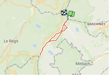
Randonnée de 9,5 km à découvrir à Grand Est, Haut-Rhin, Metzeral. Cette randonnée est proposée par Vero Sup.

Description

Hohneck et alentours

Profil altimétrique

Localisation

Pays :
France
Région :
Grand Est
Département/Province :
Haut-Rhin
Commune :
Metzeral
Localité :
Unknown
Départ:(Dec)
Départ:(UTM)
351934 ; 5322303 (32U) N.

Randonnées à proximité

Randonnée Marche La Bresse - 2023-04-16 Marche Abri Lac de Blanchemer vers Lac de Lispach - Photo
Marche
GUIDE
holtzv

Marche

Très difficile
(1)
La Bresse, Grand Est, Vosges, France
23 km | 36 km-effort
8h 4min
Non
Randonnée Marche La Bresse - Lac de Lispach et sentier Dielaine  - Photo
Marche
zazie

Marche

Moyen
(1)
La Bresse, Grand Est, Vosges, France
9,7 km | 14,9 km-effort
2h 30min
Oui
Randonnée Marche Stosswihr - Tour du belvedere avec le passage sur les crêtes  - Photo
Marche
ocepee

Marche

Très facile
(2)
Stosswihr, Grand Est, Haut-Rhin, France
8,5 km | 0 m-effort
2h 28min
Oui
Randonnée Marche La Bresse - Kastelberg des pierres, des lacs, des panoramas magnifiques  - Photo
Marche
Alfredy

Marche

Difficile
(1)
La Bresse, Grand Est, Vosges, France
15,1 km | 26 km-effort
6h 11min
Oui
Randonnée Marche La Bresse - Les 5 lacs autour du Hohneck - Photo
Marche
tiene

Marche

Très difficile
(1)
La Bresse, Grand Est, Vosges, France
21 km | 36 km-effort
7h 21min
Oui
Randonnée Marche Le Valtin - Les Hirschsteine - Photo
Marche
VacheKiri67

Marche

Difficile
(1)
Le Valtin, Grand Est, Vosges, France
16,1 km | 25 km-effort
6h 28min
Oui
Randonnée Marche La Bresse - Du Hohneck au Kastelberg par les Spietzkoepfe et le Sentier des Névées - Photo
Marche
tracegps

Marche

Très difficile
(3)
La Bresse, Grand Est, Vosges, France
7,6 km | 13,7 km-effort
3h 30min
Oui
Randonnée Marche La Bresse - Rainkopf - Mittlach - Hohneck - Photo
Marche
tracegps

Marche

Difficile
(1)
La Bresse, Grand Est, Vosges, France
22 km | 41 km-effort
8h 0min
Oui
Randonnée Marche Xonrupt-Longemer - 23-08-17 Lac Longemer - Lispach - Photo
Marche
annefrance70

Marche

Moyen
(1)
Xonrupt-Longemer, Grand Est, Vosges, France
7 km | 12,1 km-effort
2h 13min
Oui


Fermer
Mes abonnements