![](/images/other/stat-length.png)
![Randonnée Marche Vandœuvre-lès-Nancy - Vandoeuvre (Plateau de Ludres) 15 090m +359m - Photo](https://media.geolcdn.com/t/1900/400/ext.pjpeg?maxdim=2&url=https%3A%2F%2Fstatic1.geolcdn.com%2Fsiteimages%2Fupload%2Ffiles%2F1553511878bg_sport_marche.png)
Vandoeuvre (Plateau de Ludres) 15 090m +359m
DanielROLLET
Utilisateur
![Longueur](/images/other/stat-length.png)
Longueur
15 km
![Altitude max](https://static1.geolcdn.com/siteimages/upload/files/1508320355ic_sort_altitude_max_24dp.png)
Altitude max
398 m
![Dénivelé positif](https://static1.geolcdn.com/siteimages/upload/files/1508320355ic_sort_den_pos_24dp.png)
Dénivelé positif
359 m
![Km-Effort](/images/other/stat-length.png)
Km-Effort
19,8 km
![Altitude min](https://static1.geolcdn.com/siteimages/upload/files/1508320355ic_sort_altitude_min_24dp.png)
Altitude min
277 m
![Dénivelé négatif](https://static1.geolcdn.com/siteimages/upload/files/1508320355ic_sort_den_neg_24dp.png)
Dénivelé négatif
359 m
![Boucle](https://static1.geolcdn.com/siteimages/upload/files/16400158638029165_repeat_loop_refresh_sync_direction_icon.png)
Boucle
Oui
Date de création :
2023-07-16 06:50:52.39
Dernière modification :
2023-07-16 14:00:21.635
![Marche](https://static1.geolcdn.com/sitytour/trail-icons/101.png)
4h20
Difficulté : Facile
![Scannez ce code QR pour ouvrir la randonnée dans l'application SityTrail](https://capi.geolives.com/qq0zvz2zws4bq2lad0pu/sitytour/trails/3735770/qr.png?size=200)
Application GPS de randonnée GRATUITE
À propos
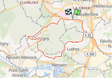
Randonnée Marche de 15 km à découvrir à Grand Est, Meurthe-et-Moselle, Vandœuvre-lès-Nancy. Cette randonnée est proposée par DanielROLLET.
Description
2023 07 16 - 8h50 à 13h10 - Beau temps
Attention : passerelle à la cote 335. Il faut passer au-dessus
Localisation
Pays :
France
Région :
Grand Est
Département/Province :
Meurthe-et-Moselle
Commune :
Vandœuvre-lès-Nancy
Localité :
Unknown
Départ:(Dec)
Départ:(UTM)
290841 ; 5391704 (32U) N.
Commentaires
Randonnées à proximité
![Randonnée A pied Fléville-devant-Nancy - Fléville-devant-Nancy et son château - Photo](https://media.geolcdn.com/t/375/260/ee7686de-cd52-43ca-b6f5-ed4c3a349bb0.jpeg&format=jpg&maxdim=2)
![A pied A pied](https://static1.geolcdn.com/sitytour/trail-icons/100.png)
Fléville-devant-Nancy et son château
A pied
Facile
Fléville-devant-Nancy,
Grand Est,
Meurthe-et-Moselle,
France
![](/images/other/stat-length.png)
7,9 km | 9,4 km-effort
2h 8min
![](https://static1.geolcdn.com/siteimages/upload/files/16400158638029165_repeat_loop_refresh_sync_direction_icon.png)
Oui
![Randonnée Vélo électrique Fléville-devant-Nancy - tour dd moselle - Photo](https://media.geolcdn.com/t/375/260/ext.jpg?maxdim=2&url=https%3A%2F%2Fstatic1.geolcdn.com%2Fsiteimages%2Fupload%2Ffiles%2F1524743154velo.jpg)
![Vélo électrique Vélo électrique](https://static1.geolcdn.com/sitytour/trail-icons/205.png)
tour dd moselle
Vélo électrique
Très facile
(1)
Fléville-devant-Nancy,
Grand Est,
Meurthe-et-Moselle,
France
![](/images/other/stat-length.png)
45 km | 55 km-effort
3h 0min
![](https://static1.geolcdn.com/siteimages/upload/files/16400158638029165_repeat_loop_refresh_sync_direction_icon.png)
Oui
![Randonnée sport Ludres - Ludres - Photo](https://media.geolcdn.com/t/375/260/4a41c09b-4979-47d6-9e86-ddd52f153625.jpg&format=jpg&maxdim=2)
Ludres
sport
Très facile
Ludres,
Grand Est,
Meurthe-et-Moselle,
France
![](/images/other/stat-length.png)
11,6 km | 14,9 km-effort
Inconnu
![](https://static1.geolcdn.com/siteimages/upload/files/16400158638029165_repeat_loop_refresh_sync_direction_icon.png)
Oui
![Randonnée Marche Ludres - SityTrail - Marche gourmande LM 11km - Photo](https://media.geolcdn.com/t/375/260/ext.jpg?maxdim=2&url=https%3A%2F%2Fstatic1.geolcdn.com%2Fsiteimages%2Fupload%2Ffiles%2F1553511878bg_sport_marche.png)
![Marche Marche](https://static1.geolcdn.com/sitytour/trail-icons/101.png)
SityTrail - Marche gourmande LM 11km
Marche
Difficile
(2)
Ludres,
Grand Est,
Meurthe-et-Moselle,
France
![](/images/other/stat-length.png)
10,4 km | 12,1 km-effort
2h 45min
![](https://static1.geolcdn.com/siteimages/upload/files/16400158638029165_repeat_loop_refresh_sync_direction_icon.png)
Oui
![Randonnée Marche Vandœuvre-lès-Nancy - Randonnée USEP 2023 - Photo](https://media.geolcdn.com/t/375/260/ext.jpg?maxdim=2&url=https%3A%2F%2Fstatic1.geolcdn.com%2Fsiteimages%2Fupload%2Ffiles%2F1553511878bg_sport_marche.png)
![Marche Marche](https://static1.geolcdn.com/sitytour/trail-icons/101.png)
Randonnée USEP 2023
Marche
Difficile
(1)
Vandœuvre-lès-Nancy,
Grand Est,
Meurthe-et-Moselle,
France
![](/images/other/stat-length.png)
11,7 km | 15,2 km-effort
3h 27min
![](https://static1.geolcdn.com/siteimages/upload/files/16400158638029165_repeat_loop_refresh_sync_direction_icon.png)
Non
![Randonnée Marche Ludres - marche nuit - Photo](https://media.geolcdn.com/t/375/260/2c15af7e-0536-4068-be2b-216477912337.jpg&format=jpg&maxdim=2)
![Marche Marche](https://static1.geolcdn.com/sitytour/trail-icons/101.png)
marche nuit
Marche
Moyen
Ludres,
Grand Est,
Meurthe-et-Moselle,
France
![](/images/other/stat-length.png)
8,7 km | 10,1 km-effort
2h 11min
![](https://static1.geolcdn.com/siteimages/upload/files/16400158638029165_repeat_loop_refresh_sync_direction_icon.png)
Oui
![Randonnée Marche Villers-lès-Nancy - RANDO DUO AVEC ALEXIS - Photo](https://media.geolcdn.com/t/375/260/ext.jpg?maxdim=2&url=https%3A%2F%2Fstatic1.geolcdn.com%2Fsiteimages%2Fupload%2Ffiles%2F1553511878bg_sport_marche.png)
![Marche Marche](https://static1.geolcdn.com/sitytour/trail-icons/101.png)
RANDO DUO AVEC ALEXIS
Marche
Difficile
(1)
Villers-lès-Nancy,
Grand Est,
Meurthe-et-Moselle,
France
![](/images/other/stat-length.png)
38 km | 45 km-effort
10h 19min
![](https://static1.geolcdn.com/siteimages/upload/files/16400158638029165_repeat_loop_refresh_sync_direction_icon.png)
Non
![Randonnée A pied Villers-lès-Nancy - Promenade d'Hardeval - Photo](https://media.geolcdn.com/t/375/260/43cb5da8-59dd-45f8-ae11-ca17f70000c7.jpeg&format=jpg&maxdim=2)
![A pied A pied](https://static1.geolcdn.com/sitytour/trail-icons/100.png)
Promenade d'Hardeval
A pied
Facile
Villers-lès-Nancy,
Grand Est,
Meurthe-et-Moselle,
France
![](/images/other/stat-length.png)
3,2 km | 4,3 km-effort
58min
![](https://static1.geolcdn.com/siteimages/upload/files/16400158638029165_repeat_loop_refresh_sync_direction_icon.png)
Oui
![Randonnée Marche nordique Ludres - Randonnée Ludres la mine la maison Patrick et Nini - Photo](https://media.geolcdn.com/t/375/260/2aa95365-fabd-4569-b6c7-48b029e99a55.jpg&format=jpg&maxdim=2)
![Marche nordique Marche nordique](https://static1.geolcdn.com/sitytour/trail-icons/102.png)
Randonnée Ludres la mine la maison Patrick et Nini
Marche nordique
Facile
Ludres,
Grand Est,
Meurthe-et-Moselle,
France
![](/images/other/stat-length.png)
6,7 km | 8,4 km-effort
1h 48min
![](https://static1.geolcdn.com/siteimages/upload/files/16400158638029165_repeat_loop_refresh_sync_direction_icon.png)
Non