![](/images/other/stat-length.png)
![Randonnée Autre activité Candé - Angers-Candé - Photo](https://media.geolcdn.com/t/1900/400/ext.pjpeg?maxdim=2&url=https%3A%2F%2Fstatic1.geolcdn.com%2Fsiteimages%2Fupload%2Ffiles%2F1545311037marcheuse_200dpi.jpg)
Angers-Candé
st141230
Utilisateur
![Longueur](/images/other/stat-length.png)
Longueur
43 km
![Altitude max](https://static1.geolcdn.com/siteimages/upload/files/1508320355ic_sort_altitude_max_24dp.png)
Altitude max
86 m
![Dénivelé positif](https://static1.geolcdn.com/siteimages/upload/files/1508320355ic_sort_den_pos_24dp.png)
Dénivelé positif
269 m
![Km-Effort](/images/other/stat-length.png)
Km-Effort
46 km
![Altitude min](https://static1.geolcdn.com/siteimages/upload/files/1508320355ic_sort_altitude_min_24dp.png)
Altitude min
9 m
![Dénivelé négatif](https://static1.geolcdn.com/siteimages/upload/files/1508320355ic_sort_den_neg_24dp.png)
Dénivelé négatif
271 m
![Boucle](https://static1.geolcdn.com/siteimages/upload/files/16400158638029165_repeat_loop_refresh_sync_direction_icon.png)
Boucle
Non
Date de création :
2014-12-30 00:00:00.0
Dernière modification :
2014-12-30 00:00:00.0
![Autre activité](https://static1.geolcdn.com/sitytour/trail-icons/900.png)
--
Difficulté : Inconnu
![Scannez ce code QR pour ouvrir la randonnée dans l'application SityTrail](https://capi.geolives.com/qq0zvz2zws4bq2lad0pu/sitytour/trails/373428/qr.png?size=200)
Application GPS de randonnée GRATUITE
À propos
Randonnée Autre activité de 43 km à découvrir à Pays de la Loire, Maine-et-Loire, Candé. Cette randonnée est proposée par st141230.
Description
Tracé de l'ancienne ligne de chemin de fer à voie métrique du Petit Anjou (OV)
Points d'intérêt
Localisation
Pays :
France
Région :
Pays de la Loire
Département/Province :
Maine-et-Loire
Commune :
Candé
Localité :
Unknown
Départ:(Dec)
Départ:(UTM)
647567 ; 5269611 (30T) N.
Commentaires
Randonnées à proximité
![Randonnée Autre activité Angrie - Candé et la chocolaterie - Photo](https://media.geolcdn.com/t/375/260/ext.jpg?maxdim=2&url=https%3A%2F%2Fservices.sitytrail.com%2FGeolivesWS%2FDownloadMedia.ashx%3FTrailID%3D889545%26Media%3D20180118152435.jpg)
![Autre activité Autre activité](https://static1.geolcdn.com/sitytour/trail-icons/900.png)
Candé et la chocolaterie
Autre activité
Très facile
(1)
Angrie,
Pays de la Loire,
Maine-et-Loire,
France
![](/images/other/stat-length.png)
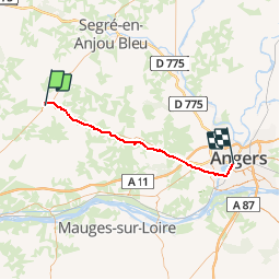
7,4 km | 8,3 km-effort
1h 33min
![](https://static1.geolcdn.com/siteimages/upload/files/16400158638029165_repeat_loop_refresh_sync_direction_icon.png)
Oui
![Randonnée Randonnée équestre Vallons-de-l'Erdre - étape 4 - Photo](https://media.geolcdn.com/t/375/260/ext.jpg?maxdim=2&url=https%3A%2F%2Fstatic1.geolcdn.com%2Fsiteimages%2Fupload%2Ffiles%2F1524743154cheval.jpg)
![Randonnée équestre Randonnée équestre](https://static1.geolcdn.com/sitytour/trail-icons/301.png)
étape 4
Randonnée équestre
Moyen
Vallons-de-l'Erdre,
Pays de la Loire,
Loire-Atlantique,
France
![](/images/other/stat-length.png)
25 km | 27 km-effort
4h 41min
![](https://static1.geolcdn.com/siteimages/upload/files/16400158638029165_repeat_loop_refresh_sync_direction_icon.png)
Non
![Randonnée Randonnée équestre Candé - etape 4 vritz La Poueze - Photo](https://media.geolcdn.com/t/375/260/ext.jpg?maxdim=2&url=https%3A%2F%2Fstatic1.geolcdn.com%2Fsiteimages%2Fupload%2Ffiles%2F1524743154cheval.jpg)
![Randonnée équestre Randonnée équestre](https://static1.geolcdn.com/sitytour/trail-icons/301.png)
etape 4 vritz La Poueze
Randonnée équestre
Facile
Candé,
Pays de la Loire,
Maine-et-Loire,
France
![](/images/other/stat-length.png)
25 km | 27 km-effort
1h 25min
![](https://static1.geolcdn.com/siteimages/upload/files/16400158638029165_repeat_loop_refresh_sync_direction_icon.png)
Non
![Randonnée Marche Candé - Candé freigne - Photo](https://media.geolcdn.com/t/375/260/ext.jpg?maxdim=2&url=https%3A%2F%2Fstatic1.geolcdn.com%2Fsiteimages%2Fupload%2Ffiles%2F1553511878bg_sport_marche.png)
![Marche Marche](https://static1.geolcdn.com/sitytour/trail-icons/101.png)
Candé freigne
Marche
Difficile
Candé,
Pays de la Loire,
Maine-et-Loire,
France
![](/images/other/stat-length.png)
12,5 km | 14 km-effort
5h 36min
![](https://static1.geolcdn.com/siteimages/upload/files/16400158638029165_repeat_loop_refresh_sync_direction_icon.png)
Oui
![Randonnée Randonnée équestre Candé - equirando vive éve -Candé - Photo](https://media.geolcdn.com/t/375/260/ext.jpg?maxdim=2&url=https%3A%2F%2Fstatic1.geolcdn.com%2Fsiteimages%2Fupload%2Ffiles%2F1524743154cheval.jpg)
![Randonnée équestre Randonnée équestre](https://static1.geolcdn.com/sitytour/trail-icons/301.png)
equirando vive éve -Candé
Randonnée équestre
Facile
Candé,
Pays de la Loire,
Maine-et-Loire,
France
![](/images/other/stat-length.png)
66 km | 72 km-effort
1h 33min
![](https://static1.geolcdn.com/siteimages/upload/files/16400158638029165_repeat_loop_refresh_sync_direction_icon.png)
Non
![Randonnée Marche Angrie - Angries - Photo](https://media.geolcdn.com/t/375/260/ext.jpg?maxdim=2&url=https%3A%2F%2Fstatic1.geolcdn.com%2Fsiteimages%2Fupload%2Ffiles%2F1553511878bg_sport_marche.png)
![Marche Marche](https://static1.geolcdn.com/sitytour/trail-icons/101.png)
Angries
Marche
Difficile
Angrie,
Pays de la Loire,
Maine-et-Loire,
France
![](/images/other/stat-length.png)
13,5 km | 14,9 km-effort
3h 18min
![](https://static1.geolcdn.com/siteimages/upload/files/16400158638029165_repeat_loop_refresh_sync_direction_icon.png)
Oui
![Randonnée Marche Angrie - Angrie - Photo](https://media.geolcdn.com/t/375/260/ext.jpg?maxdim=2&url=https%3A%2F%2Fstatic1.geolcdn.com%2Fsiteimages%2Fupload%2Ffiles%2F1553511878bg_sport_marche.png)
![Marche Marche](https://static1.geolcdn.com/sitytour/trail-icons/101.png)
Angrie
Marche
Facile
Angrie,
Pays de la Loire,
Maine-et-Loire,
France
![](/images/other/stat-length.png)
12,4 km | 13,5 km-effort
3h 0min
![](https://static1.geolcdn.com/siteimages/upload/files/16400158638029165_repeat_loop_refresh_sync_direction_icon.png)
Oui
![Randonnée Marche Angrie - Candé - Photo](https://media.geolcdn.com/t/375/260/ext.jpg?maxdim=2&url=https%3A%2F%2Fstatic1.geolcdn.com%2Fsiteimages%2Fupload%2Ffiles%2F1553511878bg_sport_marche.png)
![Marche Marche](https://static1.geolcdn.com/sitytour/trail-icons/101.png)
Candé
Marche
Facile
Angrie,
Pays de la Loire,
Maine-et-Loire,
France
![](/images/other/stat-length.png)
14 km | 15,6 km-effort
3h 25min
![](https://static1.geolcdn.com/siteimages/upload/files/16400158638029165_repeat_loop_refresh_sync_direction_icon.png)
Non