![](/images/other/stat-length.png)
![Randonnée Marche Les Avanchers-Valmorel - La pointe du Mottet - Photo](https://media.geolcdn.com/t/1900/400/2e37b825-b94f-4423-a1b3-473ac5aecc4a.jpeg&format=pjpeg&maxdim=2)
La pointe du Mottet
dautriche
Utilisateur
![Longueur](/images/other/stat-length.png)
Longueur
10,9 km
![Altitude max](https://static1.geolcdn.com/siteimages/upload/files/1508320355ic_sort_altitude_max_24dp.png)
Altitude max
2563 m
![Dénivelé positif](https://static1.geolcdn.com/siteimages/upload/files/1508320355ic_sort_den_pos_24dp.png)
Dénivelé positif
774 m
![Km-Effort](/images/other/stat-length.png)
Km-Effort
21 km
![Altitude min](https://static1.geolcdn.com/siteimages/upload/files/1508320355ic_sort_altitude_min_24dp.png)
Altitude min
1837 m
![Dénivelé négatif](https://static1.geolcdn.com/siteimages/upload/files/1508320355ic_sort_den_neg_24dp.png)
Dénivelé négatif
775 m
![Boucle](https://static1.geolcdn.com/siteimages/upload/files/16400158638029165_repeat_loop_refresh_sync_direction_icon.png)
Boucle
Oui
Date de création :
2023-07-14 07:21:06.0
Dernière modification :
2023-08-02 10:06:37.839
![Marche](https://static1.geolcdn.com/sitytour/trail-icons/101.png)
4h59
Difficulté : Moyen
![Scannez ce code QR pour ouvrir la randonnée dans l'application SityTrail](https://capi.geolives.com/qq0zvz2zws4bq2lad0pu/sitytour/trails/3733679/qr.png?size=200)
Application GPS de randonnée GRATUITE
À propos
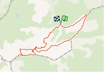
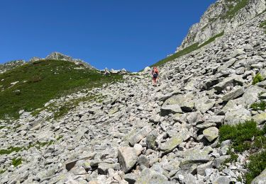
Randonnée Marche de 10,9 km à découvrir à Auvergne-Rhône-Alpes, Savoie, Les Avanchers-Valmorel. Cette randonnée est proposée par dautriche.
Description
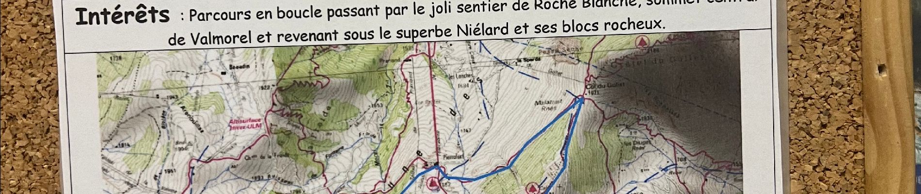
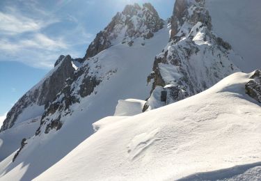
Parcours en boucle par le joli sentier de la Roche Blanche, sommet central de Valmorel et revenant sous le superbe Niélard et ses blocs rocheux.
Localisation
Pays :
France
Région :
Auvergne-Rhône-Alpes
Département/Province :
Savoie
Commune :
Les Avanchers-Valmorel
Localité :
Unknown
Départ:(Dec)
Départ:(UTM)
299853 ; 5035307 (32T) N.
Commentaires
Randonnées à proximité
![Randonnée Marche Les Belleville - Tour de Creve Tete - Photo](https://media.geolcdn.com/t/375/260/775f7fbd-61fe-4dac-aa88-5ad251aeb72f.jpg&format=jpg&maxdim=2)
![Marche Marche](https://static1.geolcdn.com/sitytour/trail-icons/101.png)
Tour de Creve Tete
Marche
Moyen
(1)
Les Belleville,
Auvergne-Rhône-Alpes,
Savoie,
France
![](/images/other/stat-length.png)
18,1 km | 34 km-effort
4h 49min
![](https://static1.geolcdn.com/siteimages/upload/files/16400158638029165_repeat_loop_refresh_sync_direction_icon.png)
Oui
![Randonnée Ski de randonnée La Léchère - grand pic - Photo](https://media.geolcdn.com/t/375/260/9cfac439-c6a9-45dc-854a-66e0fdb870fb.jpg&format=jpg&maxdim=2)
![Ski de randonnée Ski de randonnée](https://static1.geolcdn.com/sitytour/trail-icons/503.png)
grand pic
Ski de randonnée
Très facile
(1)
La Léchère,
Auvergne-Rhône-Alpes,
Savoie,
France
![](/images/other/stat-length.png)
13,8 km | 33 km-effort
3h 34min
![](https://static1.geolcdn.com/siteimages/upload/files/16400158638029165_repeat_loop_refresh_sync_direction_icon.png)
Oui
![Randonnée Ski de randonnée La Léchère - Aiguille de la Balme - Photo](https://media.geolcdn.com/t/375/260/a3d2e41a-1caa-427e-9d80-b714bd5aac52.jpg&format=jpg&maxdim=2)
![Ski de randonnée Ski de randonnée](https://static1.geolcdn.com/sitytour/trail-icons/503.png)
Aiguille de la Balme
Ski de randonnée
Moyen
La Léchère,
Auvergne-Rhône-Alpes,
Savoie,
France
![](/images/other/stat-length.png)
11,6 km | 28 km-effort
4h 19min
![](https://static1.geolcdn.com/siteimages/upload/files/16400158638029165_repeat_loop_refresh_sync_direction_icon.png)
Oui
![Randonnée Ski de randonnée La Léchère - Roche noire - Photo](https://media.geolcdn.com/t/375/260/9b9401f9-2d0c-481a-8b4d-bcf0642761c5.jpg&format=jpg&maxdim=2)
![Ski de randonnée Ski de randonnée](https://static1.geolcdn.com/sitytour/trail-icons/503.png)
Roche noire
Ski de randonnée
Moyen
La Léchère,
Auvergne-Rhône-Alpes,
Savoie,
France
![](/images/other/stat-length.png)
11 km | 26 km-effort
6h 53min
![](https://static1.geolcdn.com/siteimages/upload/files/16400158638029165_repeat_loop_refresh_sync_direction_icon.png)
Oui
![Randonnée Ski de randonnée La Léchère - les portes de Montmélian - Photo](https://media.geolcdn.com/t/375/260/88246016-bae4-428f-a0ba-d11da7754eea.jpg&format=jpg&maxdim=2)
![Ski de randonnée Ski de randonnée](https://static1.geolcdn.com/sitytour/trail-icons/503.png)
les portes de Montmélian
Ski de randonnée
Facile
La Léchère,
Auvergne-Rhône-Alpes,
Savoie,
France
![](/images/other/stat-length.png)
11,6 km | 26 km-effort
5h 41min
![](https://static1.geolcdn.com/siteimages/upload/files/16400158638029165_repeat_loop_refresh_sync_direction_icon.png)
Oui
![Randonnée Ski de randonnée La Léchère - vers le col des aiguillons et de la Valette - Photo](https://media.geolcdn.com/t/375/260/ba9d4d98-b7db-480d-a232-a3d87d71da3b.jpg&format=jpg&maxdim=2)
![Ski de randonnée Ski de randonnée](https://static1.geolcdn.com/sitytour/trail-icons/503.png)
vers le col des aiguillons et de la Valette
Ski de randonnée
Facile
La Léchère,
Auvergne-Rhône-Alpes,
Savoie,
France
![](/images/other/stat-length.png)
15,1 km | 33 km-effort
4h 49min
![](https://static1.geolcdn.com/siteimages/upload/files/16400158638029165_repeat_loop_refresh_sync_direction_icon.png)
Oui
![Randonnée Marche La Léchère - Les portes de Montmélian - Valmorel - Photo](https://media.geolcdn.com/t/375/260/fdbdf5c4-563d-4405-9050-500e2b712495.jpg&format=jpg&maxdim=2)
![Marche Marche](https://static1.geolcdn.com/sitytour/trail-icons/101.png)
Les portes de Montmélian - Valmorel
Marche
Très difficile
La Léchère,
Auvergne-Rhône-Alpes,
Savoie,
France
![](/images/other/stat-length.png)
9,7 km | 19,9 km-effort
4h 31min
![](https://static1.geolcdn.com/siteimages/upload/files/16400158638029165_repeat_loop_refresh_sync_direction_icon.png)
Oui
![Randonnée Marche Les Avanchers-Valmorel - Crêve Tête - Valmorel - Photo](https://media.geolcdn.com/t/375/260/cbe009b4-6e5b-483e-98ec-980758aaad6a.jpeg&format=jpg&maxdim=2)
![Marche Marche](https://static1.geolcdn.com/sitytour/trail-icons/101.png)
Crêve Tête - Valmorel
Marche
Facile
Les Avanchers-Valmorel,
Auvergne-Rhône-Alpes,
Savoie,
France
![](/images/other/stat-length.png)
11,6 km | 20 km-effort
4h 34min
![](https://static1.geolcdn.com/siteimages/upload/files/16400158638029165_repeat_loop_refresh_sync_direction_icon.png)
Non
![Randonnée Raquettes à neige La Léchère - Lac Arpettaz et crête du Grand Plan - Photo](https://media.geolcdn.com/t/375/260/ca1df7db-cce6-4a39-a70e-62bb781e896f.jpg&format=jpg&maxdim=2)
![Raquettes à neige Raquettes à neige](https://static1.geolcdn.com/sitytour/trail-icons/504.png)
Lac Arpettaz et crête du Grand Plan
Raquettes à neige
Difficile
La Léchère,
Auvergne-Rhône-Alpes,
Savoie,
France
![](/images/other/stat-length.png)
12 km | 22 km-effort
6h 46min
![](https://static1.geolcdn.com/siteimages/upload/files/16400158638029165_repeat_loop_refresh_sync_direction_icon.png)
Oui