![](/images/other/stat-length.png)
![Randonnée Marche Nommern - Circuit_auto-pedestre_Nommern_I - Photo](https://media.geolcdn.com/t/1900/400/ext.pjpeg?maxdim=2&url=https%3A%2F%2Fstatic1.geolcdn.com%2Fsiteimages%2Fupload%2Ffiles%2F1553511878bg_sport_marche.png)
Circuit_auto-pedestre_Nommern_I
mumu.larandonneuse
Utilisateur GUIDE
![Longueur](/images/other/stat-length.png)
Longueur
5,3 km
![Altitude max](https://static1.geolcdn.com/siteimages/upload/files/1508320355ic_sort_altitude_max_24dp.png)
Altitude max
397 m
![Dénivelé positif](https://static1.geolcdn.com/siteimages/upload/files/1508320355ic_sort_den_pos_24dp.png)
Dénivelé positif
192 m
![Km-Effort](/images/other/stat-length.png)
Km-Effort
7,9 km
![Altitude min](https://static1.geolcdn.com/siteimages/upload/files/1508320355ic_sort_altitude_min_24dp.png)
Altitude min
284 m
![Dénivelé négatif](https://static1.geolcdn.com/siteimages/upload/files/1508320355ic_sort_den_neg_24dp.png)
Dénivelé négatif
192 m
![Boucle](https://static1.geolcdn.com/siteimages/upload/files/16400158638029165_repeat_loop_refresh_sync_direction_icon.png)
Boucle
Oui
Date de création :
2023-07-03 14:45:58.901
Dernière modification :
2023-07-03 14:47:10.766
![Marche](https://static1.geolcdn.com/sitytour/trail-icons/101.png)
1h47
Difficulté : Moyen
![Scannez ce code QR pour ouvrir la randonnée dans l'application SityTrail](https://capi.geolives.com/qq0zvz2zws4bq2lad0pu/sitytour/trails/3721361/qr.png?size=200)
Application GPS de randonnée GRATUITE
À propos
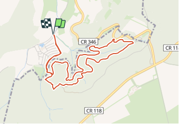
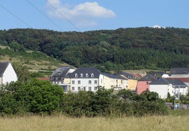
Randonnée Marche de 5,3 km à découvrir à Inconnu, Canton Mersch, Nommern. Cette randonnée est proposée par mumu.larandonneuse.
Description
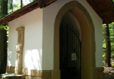
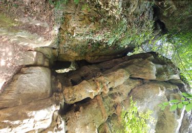
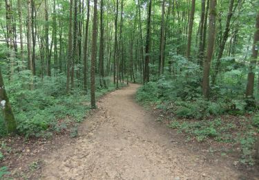
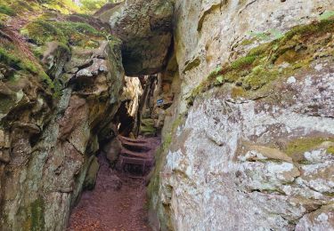
Cette petite promenade – qui contient de nombreux passages étroits et quelques marches – part à la découverte des formations rocheuses aventurières de Noumerléen avant de revenir à son point de départ.
ℹ️ visitmullerthal.lu
Localisation
Pays :
Luxembourg
Région :
Inconnu
Département/Province :
Canton Mersch
Commune :
Nommern
Localité :
Unknown
Départ:(Dec)
Départ:(UTM)
296138 ; 5518695 (32U) N.
Commentaires
Randonnées à proximité
![Randonnée Marche Larochette - MÜLLERTHAL (Larochette -superbe parcours ds les formations rocheuses) - Photo](https://media.geolcdn.com/t/375/260/ext.jpg?maxdim=2&url=https%3A%2F%2Fservices.sitytrail.com%2FGeolivesWS%2FDownloadMedia.ashx%3FTrailID%3D1016505%26Media%3Dfix__20180805123617.jpg)
![Marche Marche](https://static1.geolcdn.com/sitytour/trail-icons/101.png)
MÜLLERTHAL (Larochette -superbe parcours ds les formations rocheuses)
Marche
Facile
(1)
Larochette,
Inconnu,
Canton Mersch,
Luxembourg
![](/images/other/stat-length.png)
12,5 km | 16,5 km-effort
3h 31min
![](https://static1.geolcdn.com/siteimages/upload/files/16400158638029165_repeat_loop_refresh_sync_direction_icon.png)
Oui
![Randonnée Marche Vallée de l'Ernz - Medernach M4 - Müllerthal - Photo](https://media.geolcdn.com/t/375/260/dacd976c-3f88-4154-bdf1-ea23c611f16b.jpg&format=jpg&maxdim=2)
![Marche Marche](https://static1.geolcdn.com/sitytour/trail-icons/101.png)
Medernach M4 - Müllerthal
Marche
Moyen
(1)
Vallée de l'Ernz,
Inconnu,
Canton Diekirch,
Luxembourg
![](/images/other/stat-length.png)
13,7 km | 19,5 km-effort
4h 25min
![](https://static1.geolcdn.com/siteimages/upload/files/16400158638029165_repeat_loop_refresh_sync_direction_icon.png)
Oui
![Randonnée A pied Larochette - Rundwanderweg L4 - Photo](https://media.geolcdn.com/t/375/260/a5c036e0-acb1-47c1-a235-4038b32fbbbb.jpeg&format=jpg&maxdim=2)
![A pied A pied](https://static1.geolcdn.com/sitytour/trail-icons/100.png)
Rundwanderweg L4
A pied
Facile
Larochette,
Inconnu,
Canton Mersch,
Luxembourg
![](/images/other/stat-length.png)
10,9 km | 14,7 km-effort
3h 19min
![](https://static1.geolcdn.com/siteimages/upload/files/16400158638029165_repeat_loop_refresh_sync_direction_icon.png)
Oui
![Randonnée A pied Larochette - Rundwanderweg L2 - Photo](https://media.geolcdn.com/t/375/260/cc5d345f-0895-4078-bfe8-94230a378280.jpeg&format=jpg&maxdim=2)
![A pied A pied](https://static1.geolcdn.com/sitytour/trail-icons/100.png)
Rundwanderweg L2
A pied
Facile
(1)
Larochette,
Inconnu,
Canton Mersch,
Luxembourg
![](/images/other/stat-length.png)
8,1 km | 10,3 km-effort
2h 21min
![](https://static1.geolcdn.com/siteimages/upload/files/16400158638029165_repeat_loop_refresh_sync_direction_icon.png)
Non
![Randonnée Marche Larochette - Mullerthal Larochette L4 Hexenlee-Kauzelee-Drachenlee-Eylelee-Rammelee (PVDB) - Photo](https://media.geolcdn.com/t/375/260/5b20b19f-e10c-4d1c-af32-863a81eacd4c.jpg&format=jpg&maxdim=2)
![Marche Marche](https://static1.geolcdn.com/sitytour/trail-icons/101.png)
Mullerthal Larochette L4 Hexenlee-Kauzelee-Drachenlee-Eylelee-Rammelee (PVDB)
Marche
Difficile
Larochette,
Inconnu,
Canton Mersch,
Luxembourg
![](/images/other/stat-length.png)
12,6 km | 16,6 km-effort
3h 46min
![](https://static1.geolcdn.com/siteimages/upload/files/16400158638029165_repeat_loop_refresh_sync_direction_icon.png)
Oui
![Randonnée A pied Vallée de l'Ernz - E6 - Ermsdorf - Photo](https://media.geolcdn.com/t/375/260/eb0a04dc-66ff-44f2-83ac-5aa5e7c8563b.jpeg&format=jpg&maxdim=2)
![A pied A pied](https://static1.geolcdn.com/sitytour/trail-icons/100.png)
E6 - Ermsdorf
A pied
Facile
Vallée de l'Ernz,
Inconnu,
Canton Diekirch,
Luxembourg
![](/images/other/stat-length.png)
7,5 km | 11,2 km-effort
2h 32min
![](https://static1.geolcdn.com/siteimages/upload/files/16400158638029165_repeat_loop_refresh_sync_direction_icon.png)
Oui
![Randonnée A pied Vallée de l'Ernz - M5 - Medernach - Photo](https://media.geolcdn.com/t/375/260/6cc8ed90-52b8-4a87-9228-0b634ccd3cda.jpeg&format=jpg&maxdim=2)
![A pied A pied](https://static1.geolcdn.com/sitytour/trail-icons/100.png)
M5 - Medernach
A pied
Facile
Vallée de l'Ernz,
Inconnu,
Canton Diekirch,
Luxembourg
![](/images/other/stat-length.png)
8 km | 10,7 km-effort
2h 25min
![](https://static1.geolcdn.com/siteimages/upload/files/16400158638029165_repeat_loop_refresh_sync_direction_icon.png)
Oui
![Randonnée A pied Larochette - M4 - Medernach - Photo](https://media.geolcdn.com/t/375/260/2f12458a-4803-41cc-96f8-786d421f32c5.jpeg&format=jpg&maxdim=2)
![A pied A pied](https://static1.geolcdn.com/sitytour/trail-icons/100.png)
M4 - Medernach
A pied
Facile
(1)
Larochette,
Inconnu,
Canton Mersch,
Luxembourg
![](/images/other/stat-length.png)
7,6 km | 10 km-effort
2h 16min
![](https://static1.geolcdn.com/siteimages/upload/files/16400158638029165_repeat_loop_refresh_sync_direction_icon.png)
Oui
![Randonnée A pied Larochette - L5 - Larochette - Photo](https://media.geolcdn.com/t/375/260/2f12458a-4803-41cc-96f8-786d421f32c5.jpeg&format=jpg&maxdim=2)
![A pied A pied](https://static1.geolcdn.com/sitytour/trail-icons/100.png)
L5 - Larochette
A pied
Facile
(1)
Larochette,
Inconnu,
Canton Mersch,
Luxembourg
![](/images/other/stat-length.png)
6,6 km | 9 km-effort
2h 2min
![](https://static1.geolcdn.com/siteimages/upload/files/16400158638029165_repeat_loop_refresh_sync_direction_icon.png)
Oui