Randonnée  Schönau (Pfalz) - Oscar Vosges j2 1 - Photo
 irftz
irftz

Utilisateur

© OpenStreetMap contributors
Longueur
Longueur
7 km
Altitude max
Altitude max
553 m
Dénivelé positif
Dénivelé positif
232 m
Km-Effort
Km-Effort  
10,7 km
Altitude min
Altitude min
206 m
Dénivelé négatif
Dénivelé négatif
400 m
Boucle
Boucle
Non
Date de création :
2023-07-02 08:10:15.0
Dernière modification :
2023-07-03 07:49:31.601

(0 Avis)


Scannez ce code QR pour ouvrir la randonnée dans l'application SityTrail

Application GPS de randonnée GRATUITE

Logo SityTrail SityTrail

IGN / Instituts géographiques

Télécharger SityTrail sur l'App Store Télécharger SityTrail sur Google Play

Logo SityTrail SityTrail World

Le monde est à vous

Télécharger SityTrail sur l'App Store Télécharger SityTrail sur Google Play Télécharger SityTrail sur Huawei AppGallery

À propos

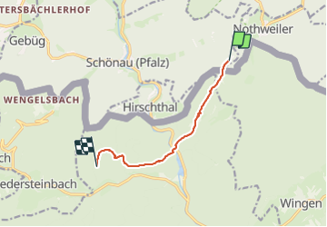
Randonnée de 7 km à découvrir à Rhénanie-Palatinat, Südwestpfalz, Schönau (Pfalz). Cette randonnée est proposée par irftz.
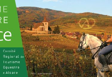
Profil altimétrique

Localisation

Pays :
Allemagne
Région :
Rhénanie-Palatinat
Département/Province :
Südwestpfalz
Commune :
Schönau (Pfalz)
Localité :
Unknown
Départ:(Dec)
Départ:(UTM)
411334 ; 5434947 (32U) N.

Randonnées à proximité

Randonnée Randonnée équestre Wingen - Boucle Loewenstein Hohenbourg Fleckenstein - Photo
Randonnée équestre
GUIDE+

Randonnée équestre

Moyen
(1)
Wingen, Grand Est, Bas-Rhin, France
18,4 km | 26 km-effort
3h 8min
Oui
Randonnée Marche Lembach - Fleckenstein, circuit des 5 châteaux. - Photo
Marche
mitch1915

Marche

Difficile
(1)
Lembach, Grand Est, Bas-Rhin, France
15,6 km | 25 km-effort
5h 6min
Oui
Randonnée A pied Lembach - Anneau jaune - Photo
A pied
GUIDE+

A pied

Facile
Lembach, Grand Est, Bas-Rhin, France
6,4 km | 9,3 km-effort
2h 6min
Oui
Randonnée A pied Wingen - Croix rouge - Photo
A pied
GUIDE+

A pied

Facile
Wingen, Grand Est, Bas-Rhin, France
5,4 km | 7,4 km-effort
1h 41min
Non
Randonnée A pied Wingen - Anneau rouge - Photo
A pied
GUIDE+

A pied

Facile
Wingen, Grand Est, Bas-Rhin, France
6,4 km | 9 km-effort
2h 2min
Oui
Randonnée A pied Lembach - Croix rouge - Photo
A pied
GUIDE+

A pied

Facile
Lembach, Grand Est, Bas-Rhin, France
4 km | 5,5 km-effort
1h 15min
Oui
Randonnée A pied Wingen - Triangle rouge - Photo
A pied
GUIDE+

A pied

Facile
Wingen, Grand Est, Bas-Rhin, France
7,5 km | 10,8 km-effort
2h 27min
Non
Randonnée A pied Lembach - Anneau bleu - Photo
A pied
GUIDE+

A pied

Facile
Lembach, Grand Est, Bas-Rhin, France
3,7 km | 5,4 km-effort
1h 14min
Oui
Randonnée A pied Niedersteinbach - Anneau bleu - Photo
A pied
GUIDE+

A pied

Facile
Niedersteinbach, Grand Est, Bas-Rhin, France
3,9 km | 6,8 km-effort
1h 32min
Oui


Fermer
Mes abonnements